Idaho State Highway 1
State Highway 1 (SH-1) is a state highway in Boundary County, in the U.S. state of Idaho. It extends 11.185 miles (18.00 km) from U.S. Route 95 (US-95) east of Copeland, north to British Columbia Highway 21 (BC 21) in Porthill. The route serves as a connector between Bonners Ferry, via US-95 south, Porthill, and Creston, BC. The highway is one of two border crossings from Idaho into British Columbia. The other crossing is at the US-95/BC 95 in Eastport.[3] The highway is also known for being the only state highway in Boundary County, the two other highways are US-95 and US-2. The highway is also part of the International Selkirk Loop, the only international scenic byway in North America.[4][5]
| ||||
|---|---|---|---|---|
| North and South Highway Copeland – Porthill Branch Copeland – Porthill Road | ||||
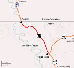 ID 1 highlighted in red. | ||||
| Route information | ||||
| Maintained by ITD | ||||
| Length | 11.185 mi[1] (18.001 km) | |||
| Existed | c. 1926[2]–present | |||
| Tourist routes | Part of the International Selkirk Loop | |||
| Major junctions | ||||
| South end | ||||
| North end | ||||
| Location | ||||
| Counties | Boundary | |||
| Highway system | ||||
| ||||

Route description
SH-1 runs 11.92 miles (19.18 km) from U.S. Route 95 (US-95) east of Copeland, north to BC 21 in Porthill. The route links Bonners Ferry, via US-95 south, Porthill, and Creston, BC.[6] The road is the only state highway in Boundary County, the two other highways are US-95 and US-2. The highway starts at an intersection with US-95 east of Copeland.[7][8]
History
SH-1 was originally created in the 1920s as part of Sampson Trail B, which ran from Boise north to Lewiston, Coeur d'Alene, before entering British Columbia at Porthill.[2] Later in the mid-1930s, Idaho adopted a new numbered highway system with SH-1 as one of the first highways.[9][10] The International Selkirk Loop, which uses SH-1, was formed in 1999.[11] The loop became an Idaho Scenic byway on January 21, 2004 as the Wild Horse Trail.[5]
Major intersections
The entire route is in Boundary County.
| Location | mi[1] | km | Destinations | Notes | |
|---|---|---|---|---|---|
| Copeland | 0.000 | 0.000 | Southern terminus | ||
| Porthill | 11.130 | 17.912 | U.S. Customs Building | ||
| 11.185 | 18.001 | Northern terminus; Continues into British Columbia as BC 21 | |||
| 1.000 mi = 1.609 km; 1.000 km = 0.621 mi | |||||
References
- Staff (January 29, 2008). "Milepost Log: State Highway 1". Idaho Transportation Department. Archived from the original on December 12, 2012. Retrieved October 4, 2008.
- Auto Road Atlas (Map) (1926 ed.). Rand McNally and Company. 1926. § A2.
- Idaho Transportation Department (May 22, 2007). "Bonners Ferry Port of Entry". Archived from the original on October 23, 2008. Retrieved October 4, 2008.
- United States Department of Transportation. "America's Scenic Byways: International Selkirk Loop". Retrieved October 4, 2008.
- Kootenai National Wildlife Refuge (January 24, 2004). "International Selkirk Loop Receives Idaho State Scenic Byway Status". Bonners Ferry, Idaho: Kootenai National Wildlife Refuge.
- The Road Atlas (Map). Rand McNally. 2008. p. 31. § A2. ISBN 0-528-93961-0.
- State Highway 1 Overview Map (Map). Cartography by NATVEQ. Google Maps. 2008. Retrieved September 25, 2008.
- Idaho Official State Highway Map (Map) (2009 ed.). Cartography by State of Idaho. Idaho Transportation Department. 2009.
- Western States road map (Map) (1935 ed.). Cartography by H.M. Gousha Company. Standard Oil Company. 1935.
- Road map: Idaho, Montana, Wyoming (Map) (1937 ed.). Cartography by Rand McNally and Company. Texaco. 1937. Retrieved October 4, 2008.
- SlekrikLoop.org. "A Brief History of the Loop". Retrieved October 4, 2008.
External links
![]() Media related to Idaho State Highway 1 at Wikimedia Commons
Media related to Idaho State Highway 1 at Wikimedia Commons