Idaho State Highway 200
State Highway 200 (SH-200) is an east–west state highway in northern Idaho, United States. It travels along the north side of Lake Pend Oreille and the Clark Fork River between the Sandpoint area and the Montana border, where it continues as Montana Highway 200. The highway is also a national scenic byway that is named the Pend Oreille Scenic Byway.[3] This state highway is part of a continuous chain of similarly numbered state highways that stretch from Minnesota to Idaho.
| ||||
|---|---|---|---|---|
| Pend Oreille National Scenic Byway | ||||
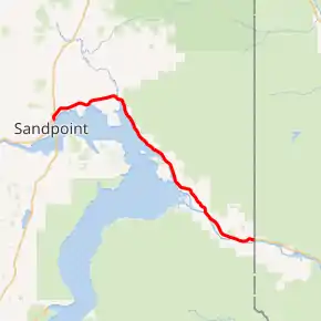
SH-200 highlighted in red | ||||
| Route information | ||||
| Maintained by ITD | ||||
| Length | 33.348 mi[1] (53.668 km) | |||
| Existed | c. 1968[2]–present | |||
| Tourist routes | ||||
| Major junctions | ||||
| West end | ||||
| East end | ||||
| Location | ||||
| Counties | Bonner | |||
| Highway system | ||||
| ||||

Route description
Idaho SH-200 starts at a junction with U.S. Highway 95 in Ponderay, a small community north of Sandpoint. The highway heads eastward along the north shores of lake Pend Oreille at the very feet of the Cabinet Mountains with several turnouts and scenic overlooks. After the town of Clark Fork it then enters the Clark Fork River Valley following the Clark Fork River and ends at the Montana border just before Heron, MT where it becomes Montana Highway 200.
The road passes through the towns of Ponderay, Kootenai, Hope, East Hope, and Clark Fork.
ID-200 is the westernmost portion of a chain of Highway 200s which extends east through Montana, North Dakota, and Minnesota. At only 33 miles (53 km) in length, Idaho's Highway 200 is the shortest in the chain while Montana's Highway 200 is the longest. There is another highway called SR 20 in Washington that would complete the chain of Hwy 200s, but ID-200 is no longer directly connected to WA-20.
History
From 1941 to 1967, the route had been signed as U.S. Route 10A.[4] After that highway's decommissioning, Idaho State Highway 200 was created to replace it. By 2007, the portion of Highway 200 west of the US 2/95 intersection had been terminated. Mileposts still display it's pre-2007 length.
Major intersections
The entire route is in Bonner County.
| Location | mi[1] | km | Destinations | Notes | |
|---|---|---|---|---|---|
| Ponderay | 29.740 | 47.862 | |||
| Hope | 44.610 | 71.793 | |||
| East Hope | 46.160 | 74.287 | |||
| | 63.118 | 101.579 | Continuation into Montana | ||
| 1.000 mi = 1.609 km; 1.000 km = 0.621 mi | |||||
Business route
| |
|---|---|
| Location | Hope, Idaho |
| Length | 1.58 mi (2.54 km) |
State Highway 200 Business (SH-200 BUS) is a business route of Highway 200 that runs through Hope, Idaho.
References
- Idaho Transportation Department (January 29, 2008). "Milepost Log". Archived from the original on December 13, 2012. Retrieved 2008-04-28.
- Geological Survey (U.S.); Gerlach, Arch C. (1970). The national atlas of the United States of America (Map). United States: Geological Survey (U.S.). p. 35. Retrieved October 29, 2020.CS1 maint: multiple names: authors list (link)
- http://www.fhwa.dot.gov/byways/byways/2044/maps
- Idaho Department of Highways; Rand McNally & Co. (1967). Official Highway Map of Idaho (Map). c. 1:1,425,600. Boise: Idaho Department of Highways. Retrieved October 28, 2020 – via Flickr.
External links
| Wikimedia Commons has media related to Idaho State Highway 200. |
- Pend Oreille Scenic Byway
- National Scenic Byways Program, Pend Oreille Scenic Byway
- "Pend Oreille - Idaho Scenic Byway". Archived from the original on 2008-05-17.
