Illinois Route 14
Illinois Route 14 (IL 14) is a major east–west highway in southern Illinois. It runs from U.S. Route 51 south of Du Quoin to the New Harmony Toll Bridge over the Wabash River to State Road 66 at the Indiana state line. This is a distance of 76.24 miles (122.70 km).[1]
| |||||||
|---|---|---|---|---|---|---|---|
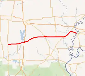
IL 14 highlighted in red | |||||||
| Route information | |||||||
| Maintained by IDOT | |||||||
| Length | 76.24 mi[1] (122.70 km) | ||||||
| Existed | November 5, 1918[2]–present | ||||||
| Major junctions | |||||||
| West end | |||||||
| East end | |||||||
| Location | |||||||
| Counties | Perry, Franklin, Hamilton, White | ||||||
| Highway system | |||||||
| |||||||


Route description
Illinois 14 runs mostly east–west from Du Quoin to New Harmony, Indiana via State Road 66.

The eastern terminus of Illinois 14 is the New Harmony Toll Bridge to New Harmony, Indiana, which bridges the states of Illinois and Indiana. The bridge is a four-span truss bridge built in 1931.[3] It was originally built as a toll bridge, but has been closed to automobile traffic since May 21, 2012.
History
Illinois Route 14 followed the present-day routing of Illinois 14, from Du Quoin to Carmi. In 1937 it was extended east to its current terminus across from New Harmony, Indiana, replacing Illinois Route 139 in the process.
From 1947 to 1974, U.S. Route 460 replaced Illinois 14 between McLeansboro and the Indiana state line; after 1974, the extended routing of 1937 was restored.[2]
Major intersections
| County | Location | mi[4] | km | Destinations | Notes |
|---|---|---|---|---|---|
| Perry | | 0.0 | 0.0 | Western terminus | |
| Franklin | Mulkeytown | 6.7 | 10.8 | ||
| Christopher | 10.0 | 16.1 | |||
| West City | 16.6 | 26.7 | I-57 exit 71 | ||
| Benton | 17.4 | 28.0 | West end of IL 37 overlap | ||
| 18.3 | 29.5 | East end of IL 37 overlap | |||
| Hamilton | McLeansboro | 41.0 | 66.0 | ||
| White | | 52.0 | 83.7 | ||
| Carmi | 61.4 | 98.8 | West end of IL 1 overlap | ||
| Crossville | 69.0 | 111.0 | East end of IL 1 overlap | ||
| Wabash River | 76.24 | 122.70 | New Harmony Toll Bridge | ||
| Continuation into Indiana | |||||
1.000 mi = 1.609 km; 1.000 km = 0.621 mi
| |||||
References
- Illinois Technology Transfer Center (2007). "T2 GIS Data". Retrieved November 8, 2007.
- Carlson, Rich. Illinois Highways Page: Routes 1 thru 20. Last updated March 15, 2006. Retrieved April 2, 2006.
- Baughn, James, et al. Historic Bridges of the Midwest: New Harmony Bridge, White County, Illinois. Retrieved April 2, 2006.
- Google Maps,