McLeansboro, Illinois
McLeansboro (/məkˈleɪnzbəroʊ/) is a city in Hamilton County, Illinois, United States. The population was 2,883 at the 2010 census. The estimated population as of 2018 was 2,773.[3] It is the county seat of Hamilton County.[4]
McLeansboro, Illinois | |
|---|---|
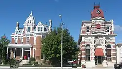 Street view of the Aaron G. Cloud House and the Cloud State Bank, located at 164 and 108 S. Washington Street in McLeansboro | |
| Etymology: Mclean | |
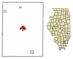 Location of McLeansboro in Hamilton County, Illinois. | |
.svg.png.webp) Location of Illinois in the United States | |
| Coordinates: 38°5′35″N 88°32′10″W | |
| Country | United States |
| State | Illinois |
| County | Hamilton |
| City | McLeansboro |
| Government | |
| • Mayor | Dick Deitz |
| Area | |
| • Total | 2.95 sq mi (7.63 km2) |
| • Land | 2.82 sq mi (7.30 km2) |
| • Water | 0.13 sq mi (0.34 km2) |
| Population (2010) | |
| • Total | 2,883 |
| • Estimate (2019)[2] | 2,746 |
| • Density | 974.80/sq mi (376.31/km2) |
| Time zone | UTC-6 (CST) |
| • Summer (DST) | UTC-5 (CDT) |
| ZIP Code(s) | 62859 |
| Area code(s) | 618 |
| FIPS code | 17-45824 |
| Wikimedia Commons | McLeansboro, Illinois |
| Website | mcleansboro |
McLeansboro is part of the Mount Vernon, Illinois micropolitan area.
Geography
McLeansboro is located at 38°5′35″N 88°32′10″W (38.093115, -88.536213).[5]
According to the 2010 census, McLeansboro has a total area of 2.741 square miles (7.10 km2), of which 2.61 square miles (6.76 km2) (or 95.22%) is land and 0.131 square miles (0.34 km2) (or 4.78%) is water.[6]
History
The city was named for Dr. William McLean, an early settler.[7]
Demographics
| Historical population | |||
|---|---|---|---|
| Census | Pop. | %± | |
| 1850 | 221 | — | |
| 1860 | 446 | 101.8% | |
| 1870 | 683 | 53.1% | |
| 1880 | 1,341 | 96.3% | |
| 1890 | 1,355 | 1.0% | |
| 1900 | 1,758 | 29.7% | |
| 1910 | 1,796 | 2.2% | |
| 1920 | 1,927 | 7.3% | |
| 1930 | 2,162 | 12.2% | |
| 1940 | 2,528 | 16.9% | |
| 1950 | 3,008 | 19.0% | |
| 1960 | 2,951 | −1.9% | |
| 1970 | 2,630 | −10.9% | |
| 1980 | 2,960 | 12.5% | |
| 1990 | 2,677 | −9.6% | |
| 2000 | 2,945 | 10.0% | |
| 2010 | 2,883 | −2.1% | |
| 2019 (est.) | 2,746 | [2] | −4.8% |
| U.S. Decennial Census[8] | |||
As of the census[9] of 2000, there were 2,945 people, 1,265 households, and 747 families residing in the city. The population density was 1,286.3 people per square mile (496.5/km2). There were 1,444 housing units at an average density of 630.7/sq mi (243.5/km2). The racial makeup of the city was 98.10% White, 0.78% African American, 0.03% Native American, 0.20% Asian, 0.03% Pacific Islander, 0.17% from other races, and 0.68% from two or more races. Hispanic or Latino of any race were 0.37% of the population.
There were 1,265 households, out of which 26.0% had children under the age of 18 living with them, 44.6% were married couples living together, 11.1% had a female householder with no husband present, and 40.9% were non-families. 38.4% of all households were made up of individuals, and 23.9% had someone living alone who was 65 years of age or older. The average household size was 2.19 and the average family size was 2.91.
In the city, the population was spread out, with 22.8% under the age of 18, 8.3% from 18 to 24, 22.7% from 25 to 44, 20.6% from 45 to 64, and 25.7% who were 65 years of age or older. The median age was 42 years. For every 100 females there were 81.3 males. For every 100 females age 18 and over, there were 74.4 males.
The median income for a household in the city was $22,183, and the median income for a family was $35,296. Males had a median income of $35,114 versus $18,125 for females. The per capita income for the city was $15,354. About 11.9% of families and 19.7% of the population were below the poverty line, including 34.7% of those under age 18 and 8.6% of those age 65 or over. As of 2015, the median household income was reported at $36,717 and the median family income at $54,430. 18.9% of the population were living below the poverty line.[10][11]
Notable people
- Elwood Barker, businessman, farmer, and Illinois state legislator
- Ray Blades, baseball player.
- Paul W. Broyles, businessman and Illinois state legislator
- Jim Burns, former U. S. Attorney, Inspector General for the Illinois Secretary of State from 2000 until 2020
- Christen Drew, news reporter
- Carl Mauck, former center for the Houston Oilers and National Football League
- Jerry Sloan, Basketball Hall of Famer, player and head coach for the Chicago Bulls and head coach of the Utah Jazz
- H. Allen Smith, author
- John H. Stelle, lieutenant governor 1937–40, 29th Governor of Illinois 1940-41
- Henry C. Warmoth, 23rd Governor of Louisiana
- Rodney K. Miller, television host for Small Town Big Deal
References
- "2019 U.S. Gazetteer Files". United States Census Bureau. Retrieved July 14, 2020.
- "Population and Housing Unit Estimates". United States Census Bureau. May 24, 2020. Retrieved May 27, 2020.
- "Population and Housing Unit Estimates". Retrieved December 2, 2019.
- "Find a County". National Association of Counties. Archived from the original on May 31, 2011. Retrieved 2011-06-07.
- "US Gazetteer files: 2010, 2000, and 1990". United States Census Bureau. 2011-02-12. Retrieved 2011-04-23.
- "G001 - Geographic Identifiers - 2010 Census Summary File 1". United States Census Bureau. Archived from the original on 2020-02-13. Retrieved 2015-12-27.
- Gannett, Henry (1905). The Origin of Certain Place Names in the United States. U.S. Government Printing Office. p. 194.
- "Census of Population and Housing". Census.gov. Retrieved June 4, 2015.
- "U.S. Census website". United States Census Bureau. Retrieved 2008-01-31.
- "McLeansboro, Illinois". Retrieved July 24, 2017.
- "McLeansboro, Illinois (IL) income map, earnings map, and wages data". Retrieved July 24, 2017.
Further reading
- History of Southern Illinois, George Washington Smith, 1912.
External links
- McLeansboro.com
- Hamilton County Historical Society
- Hamilton County Foxes Football
- McLeansboro FGB Church
- Hamilton County Chamber of Commerce
Municipalities and communities of Hamilton County, Illinois, United States | ||
|---|---|---|
| Cities | Map of Illinois highlighting Hamilton County | |
| Town | ||
| Villages | ||
| Townships | ||
| Unincorporated communities | ||
| Footnotes | ‡This populated place also has portions in an adjacent county or counties | |
| ||
| Authority control |
|---|