Illinois Route 7
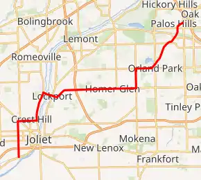
Illinois Route 7 (IL 7) is a northeast–southwest state road in northeastern Illinois. Currently, Illinois 7 runs from U.S. Route 6 at Rockdale north through Joliet, and Crest Hill into Lockport, and then east to Orland Park before terminating at Illinois Route 43 in Worth. Illinois 7 runs for about 28.06 miles (45.16 km).[1]
| ||||
|---|---|---|---|---|
| Larkin Avenue 159th Street Southwest Highway | ||||
IL 7 highlighted in red | ||||
| Route information | ||||
| Maintained by IDOT | ||||
| Length | 28.06 mi[1] (45.16 km) | |||
| Existed | November 5, 1918[2]–present | |||
| Major junctions | ||||
| South[3] end | ||||
| North end | ||||
| Location | ||||
| Counties | Will, Cook | |||
| Highway system | ||||
| ||||

Route description
Illinois 7 follows large portions of the Southwest Highway, one of the original routes from Chicago to Joliet.
Illinois 7 runs along many major streets and overlaps several other routes. It joins with Illinois Route 53 in Crest Hill, Rt.30 (Plainfield Road in Crest Hill and with U.S. 6 at 159th Street between Lockport and Orland Park. Between Rockdale and Worth, Illinois 7 runs along old U.S. Route 66, 159th Street, 143rd Street, Wolf Road, Southwest Highway, and Larkin Avenue, among many others.
History
SBI Route 7 originally ran from East Moline to Chicago, mostly on current U.S. 6 and Illinois 7. When U.S. 6 was designated, Illinois 7 was dropped west of what is now Orland Park. In 1967, it was dropped in the city limits of Chicago (terminating in Oak Lawn, and also extended to Illinois Route 53 in Lockport. Two years later, it was extended to Rockdale. In 1970, the eastern end was cut back to its current terminus.[2]
Major intersections
| County | Location | mi[1][4] | km | Destinations | Notes |
|---|---|---|---|---|---|
| Will | Rockdale | 0.0 | 0.0 | Southern terminus | |
| Joliet | 1.0 | 1.6 | I-80 Exit 130 | ||
| 1.8 | 2.9 | ||||
| 4.0 | 6.4 | ||||
| Crest Hill | 5.7 | 9.2 | Southwest end of IL 53/Historic US 66 overlap | ||
| Romeoville | 8.7 | 14.0 | Northeast end of IL 53/Historic US 66 overlap | ||
| Lockport | 9.7 | 15.6 | |||
| 12.4 | 20.0 | I-355 Exit 4 | |||
| Cook | Orland Park | 18.6 | 29.9 | ||
| 22.7 | 36.5 | Access via 135th and 143th Streets | |||
| Palos Park | 25.3 | 40.7 | 123rd Street, McCarthy Road | Interchange | |
| 26.2 | 42.2 | ||||
| Worth | 28.2 | 45.4 | Northern terminus | ||
| Southwest Highway | Continuation beyond IL 43 | ||||
1.000 mi = 1.609 km; 1.000 km = 0.621 mi
| |||||
External links
References
- Illinois Technology Transfer Center (2007). "T2 GIS Data". Retrieved November 8, 2007.
- Carlson, Rick. Illinois State Highways Page: Routes 1 thru 20. Last updated March 15, 2006. Retrieved March 24, 2006.
- Burmaster, Bill. Roads of the Mid-South and West - Illinois State Route 7. Retrieved March 24, 2006.
- Google Maps estimate