Illinois Route 72
Illinois Route 72 is an east–west state road in northern Illinois. It runs from the intersection with Illinois Route 73 north of Lanark east to Illinois Route 43 (Harlem Avenue) in Chicago. This is a distance of 110.71 miles (178.2 km).[1]
| ||||
|---|---|---|---|---|
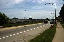
| Higgins Road Touhy Avenue | ||||
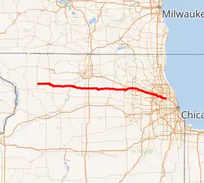
IL 72 highlighted in red | ||||
| Route information | ||||
| Maintained by IDOT and CDOT | ||||
| Length | 110.71 mi[1] (178.17 km) | |||
| Existed | 1924[2]–present | |||
| Major junctions | ||||
| West end | ||||
| East end | ||||
| Location | ||||
| Counties | Carroll, Ogle, DeKalb, Kane, Cook | |||
| Highway system | ||||
| ||||

Route description
Illinois 72 is called Higgins Road for most of its length in the Chicago area, and has been redirected in parts of the area to accommodate for new features. Near Rosemont, the road has been shifted to make way for O'Hare International Airport — further east, parts of the road have been moved to make room for the Northwest Tollway (Interstate 90). The road serves as a major six-lane thoroughfare for several western suburbs, including Schaumburg, Elk Grove Village, and Hoffman Estates.
Illinois 72 runs concurrently for one block with Illinois Route 83 in Elk Grove Township, and Illinois Route 47 and U.S. Highway 20 by Starks, an unincorporated village approximately 60 miles (97 km) from Chicago. The latter is a Wrong-way concurrency, where one can be driving both west on Illinois 72 and east on U.S. 20 at the same time. West from Chicago, Illinois 72 largely parallels Interstate 90 until Starks, crossing over and under the highway six times without an intersection. On a larger scale, it is the main east–west artery to Chicago between Interstate 90 and Illinois Route 64.
It serves the towns and cities of, from west to east, Lanark, Shannon, Forreston, Leaf River, Byron, Stillman Valley, Kirkland, Kingston, Genoa, Hampshire, Gilberts, Sleepy Hollow, West Dundee, East Dundee, South Barrington, Hoffman Estates, Schaumburg, Elk Grove Village, Des Plaines, Rosemont, and Chicago. Higgins Road/Higgins Avenue continues east-southeast from Harlem Avenue in Chicago to Milwaukee Avenue near Lawrence Avenue.
Route 72 is one of seven state roads to enter the city of Chicago. It was once part of the Galena-Chicago Stagecoach Trail.
History
SBI Route 72 originally ran from Lanark to Starks. It was extended east in 1937 and 1938 to East Dundee, and then to Chicago. In 1968, the designation of IL 72 was truncated back to IL 43 (Harlem Avenue), lopping off 10.5 miles (16.9 km).[3] In 1982, it was shortened again, this time to Illinois Route 73.[2]
The crash site of American Airlines Flight 191 is located along the road as Touhy Avenue, just north of the road and north of O'Hare International Airport near a trailer park.
Major intersections
| County | Location | mi[4] | km | Destinations | Notes |
|---|---|---|---|---|---|
| Carroll | Lanark | 0.00 | 0.00 | Western terminus of IL 72 | |
| Ogle | Forreston | 10.0 | 16.1 | West end of IL 26 concurrency | |
| 13.9 | 22.4 | East end of IL 26 concurrency | |||
| Byron | 29.6 | 47.6 | West end of IL 2 concurrency | ||
| 30.9 | 49.7 | East end of IL 2 concurrency | |||
| Davis Junction | 40.8 | 65.7 | |||
| Monroe Center | 43.5 | 70.0 | Exit 111 (I-39) | ||
| DeKalb | Genoa | 61.7 | 99.3 | West end of IL 23 concurrency | |
| 63.6 | 102.4 | East end of IL 23 concurrency | |||
| Pingree Grove | 73.7 | 118.6 | West end of US 20 / IL 47 concurrency | ||
| Starks | 74.2 | 119.4 | East end of US 20 / IL 47 concurrency | ||
| Kane | West Dundee | 83.2 | 133.9 | ||
| East Dundee | 84.1 | 135.3 | Western terminus of IL 68 | ||
| 84.8 | 136.5 | ||||
| Cook | Sutton | 88.6 | 142.6 | ||
| Hoffman Estates–Schaumburg village line | 93.8 | 151.0 | |||
| Schaumburg | 97.2 | 156.4 | Exit 1 (I-290) | ||
| Elk Grove Village | 101.2 | 162.9 | West end of IL 83 concurrency | ||
| 101.2 | 162.9 | East end of IL 83 concurrency | |||
| Des Plaines | Future Interchange | ||||
| 105.2 | 169.3 | Exit 76 (I-90); no access to I-90 west or from I-90 east | |||
| 106.0 | 170.6 | ||||
| 106.6 | 171.6 | Access only | |||
| Chicago | 108.7 | 174.9 | Northern terminus of IL 171 | ||
| 109.4 | 176.1 | Exit 80 (I-90) | |||
| 110.5 | 177.8 | Exi 81A (I-90) | |||
| 110.71 | 178.17 | Eastern terminus of IL 72 | |||
1.000 mi = 1.609 km; 1.000 km = 0.621 mi
| |||||
See also
References
- Illinois Technology Transfer Center (2007). "T2 GIS Data". Retrieved 2007-11-08.
- Carlson, Rick. Illinois State Highways Page: Routes 61 thru 80. Last updated March 15, 2006. Retrieved March 24, 2006.
- "Irving Park Road Gets Route Change". The Chicago Tribune. March 28, 1968. p. N3.
- Google (February 22, 2017). "Overview Map of IL 72" (Map). Google Maps. Google. Retrieved February 22, 2017.
External links
| Wikimedia Commons has media related to Illinois Route 72. |