Indian River (Mullett Lake)
Indian River in the Lower Peninsula of Michigan is a 3.9-mile-long (6.3 km)[3] waterway in Cheboygan County that flows from Burt Lake at 45°24′37″N 84°37′19″W to Mullett Lake at 45°27′05″N 84°34′39″W.[2] The unincorporated community of Indian River is named after the river.
| Indian River | |
|---|---|
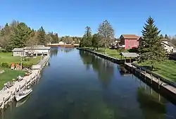 The Indian River viewed from the North Central State Trail in the community of Indian River | |
| Location | |
| Country | United States |
| Physical characteristics | |
| Source | |
| • location | Burt Lake, Cheboygan County, Michigan |
| • elevation | 594 ft (181 m)[1] |
| Mouth | |
• location | Mullett Lake, Cheboygan County, Michigan |
• elevation | 594 ft (181 m)[2] |
The river is part of the great Inland Waterway of Michigan, by which one can boat from Crooked Lake several miles east of Petoskey on the Little Traverse Bay of Lake Michigan across the northern tip of the lower peninsula's "mitten" to Cheboygan on Lake Huron.
References
- U.S. Geological Survey Geographic Names Information System: Burt Lake
- U.S. Geological Survey Geographic Names Information System: Indian River
- U.S. Geological Survey. National Hydrography Dataset high-resolution flowline data. The National Map Archived 2012-04-05 at WebCite, accessed November 21, 2011
This article is issued from Wikipedia. The text is licensed under Creative Commons - Attribution - Sharealike. Additional terms may apply for the media files.