Indiana State Road 163
State Road 163 in the U.S. State of Indiana is a short 9-mile (14 km) route in Vermillion and Parke counties. Though it is an odd-numbered route, it is an east–west route.
| ||||
|---|---|---|---|---|
 | ||||
| Route information | ||||
| Maintained by INDOT | ||||
| Length | 8.886 mi[1] (14.301 km) | |||
| Existed | 1931[2]–present | |||
| Major junctions | ||||
| West end | IL border west of Blanford | |||
| East end | ||||
| Location | ||||
| Counties | Parke, Vermillion | |||
| Highway system | ||||
| ||||

Route description
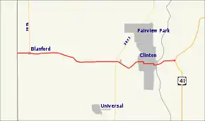
State Road 163 travels from the Illinois border in the town of Blanford and proceeds east through Centenary. It then crosses State Road 63 and proceeds into Clinton where it follows several streets on its way through the middle of town: Western Avenue, 9th street, Elm Street, Main Street, and Walnut Street. It then crosses the Wabash River at the east edge of town and joins U.S. Route 41 about a mile east of the river.
Major intersections
| County | Location | mi[1] | km | Destinations | Notes |
|---|---|---|---|---|---|
| Vermillion | Clinton Township | 0.00 | 0.00 | Edgar CR 1300 N (Clinton Road) Edgar CR 2523 E | West end of SR 163 at Illinois border |
| Blanford | 0.635 | 1.022 | Southern terminus of SR 71 | ||
| Clinton | 5.367 | 8.637 | |||
| Parke | Florida Township | 8.886 | 14.301 | East end of SR 163 | |
| 1.000 mi = 1.609 km; 1.000 km = 0.621 mi | |||||
References
- Indiana Department of Transportation (July 2016). Reference Post Book (PDF). Indianapolis: Indiana Department of Transportation. Retrieved February 3, 2017.
- "Maintenance on 391". The Franklin Eveing Star. September 25, 1931. p. 3. Retrieved October 20, 2016 – via Newspapers.com.

External links
This article is issued from Wikipedia. The text is licensed under Creative Commons - Attribution - Sharealike. Additional terms may apply for the media files.
