Indiana State Road 168
State Road 168 is a 17-mile-long (27 km) east–west two-lane highway that exists entirely within Gibson County in the far southwestern portion of the state, spanning Barton, Montgomery, and Union townships.
| ||||
|---|---|---|---|---|
 | ||||
| Route information | ||||
| Maintained by INDOT | ||||
| Length | 17.179 mi[1] (27.647 km) | |||
| Major junctions | ||||
| West end | ||||
| East end | ||||
| Location | ||||
| Counties | Gibson | |||
| Highway system | ||||
| ||||

Route description
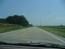
Indiana 168 seen from a Toyota's dash in 2007, near Gibson Southern High School and Owensville, Indiana. Fort Branch, Indiana can be seen in the distance.
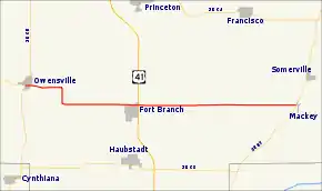
State Road 168 runs from State Road 65 in Owensville, through the north side of Fort Branch, to State Road 57 in Mackey. Its route runs about 3 miles (4.8 km) north of, and parallel to, its parent highway, State Road 68.
State Road 168 intersects with U.S. Route 41 and Interstate 69; the latter opened on November 15, 2012.
Major intersections
The entire route is in Gibson County.
| Location | mi[1] | km | Destinations | Notes | |
|---|---|---|---|---|---|
| Owensville | 0.000 | 0.000 | Western terminus of SR 168 | ||
| Fort Branch | 7.672 | 12.347 | |||
| Barton Township | 14.886– 15.082 | 23.957– 24.272 | |||
| Mackey | 17.179 | 27.647 | Eastern terminus of SR 168 | ||
| 1.000 mi = 1.609 km; 1.000 km = 0.621 mi | |||||
References
- Indiana Department of Transportation (July 2015). Reference Post Book (PDF). Indianapolis: Indiana Department of Transportation. Retrieved October 26, 2015.
External links
This article is issued from Wikipedia. The text is licensed under Creative Commons - Attribution - Sharealike. Additional terms may apply for the media files.