Indiana State Road 350
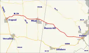
State Road 350 (SR 350) is a state road in the south–eastern section of the state of Indiana. Running for about 23 miles (37 km) in a general east–west direction, connecting Osgood, Milan, and Aurora. SR 350 was originally introduced in the 1931 routed between Milan and Aurora. The road was extended west to the Osgood in 1932. In 1950s the SR 350 had a couple of minor realignments and a segment was paved. The rest of the route was paved in the early 1960s.
| ||||
|---|---|---|---|---|
 | ||||
| Route information | ||||
| Maintained by INDOT | ||||
| Length | 23.416 mi[1] (37.684 km) | |||
| Existed | 1931[2]–present | |||
| Major junctions | ||||
| West end | ||||
| East end | ||||
| Location | ||||
| Counties | Dearborn, Ripley | |||
| Highway system | ||||
| ||||
Route description
SR 350 starts in Osgood at the corner of Buckeye Street and Beech Street. Buckeye Street runs northwest–southeast carrying U.S. Route 421, and Beech Street runs northeasterly from here carrying SR 350. The highway passes through residential neighborhoods, before leaving Osgood. After leaving Osgood the road turns more east–west passing through rural Ripley County. The highway enters the community of Delaware and has an intersection with SR 129. After SR 129 the road becomes southeast–northwest and heads towards Pierceville. In Pierceville the road parallels a CSX Transportation rail track, passing a few residential properties.[3][4][5]
East of Pierceville SR 350 turns towards the east leaves the rail track and passes through rural Ripley County for a short distance before entering the town of Milan. The highway passes through the northern part of Milan and an intersection with SR 101. After Milan the road turns towards the southeast and passes north of Moores Hill, before passing through rural Dearborn County. While in rural Dearborn County the road passes near Sparta, Mount Sinai, and just north of Wilmington. East of Wilmington SR 350 passes South Dearborn High School, before entering Aurora. In Aurora the roadway crosses over the south fork of the Hogan Creek. The SR 350 designation ends at an intersection with US 50 crossing northeast–southwest and SR 56 continuing towards the southeast.[3][4]
History
SR 350 had its beginning in 1931 when it was designated, by Indiana State Highway Commission, from Milan to Aurora.[2] By September 1932 SR 350 was extended west to an intersection with SR 29 (now US 421), in Osgood.[6][7] The road was moved to its modern routing between Sparta and north of Milan between 1956 and 1957.[8][9] Between 1957 and 1959 the road was rerouted around Mount Sinai onto the modern routing. At the same time the road was paved between the eastern in of the reroute and Wilmington was paved.[9][10] The rest of SR 350 was paved between 1960 and 1961.[11][12] Since the road was paved, SR 350 has not undergone any major changes.[4]
Major intersections
| County | Location | mi[1] | km | Destinations | Notes |
|---|---|---|---|---|---|
| Ripley | Osgood | 0.000 | 0.000 | Western terminus of SR 350 | |
| Delaware | 5.159 | 8.303 | |||
| Milan | 9.448 | 15.205 | |||
| Dearborn | Aurora | 23.416 | 37.684 | Eastern terminus of SR 350; Eastern terminus of SR 56 | |
| 1.000 mi = 1.609 km; 1.000 km = 0.621 mi | |||||
References
- Indiana Department of Transportation (July 2015). Reference Post Book (PDF). Indianapolis: Indiana Department of Transportation. Retrieved October 3, 2016.
- "Maintenance on 391". The Franklin Evening Star. September 25, 1931. p. 3. Retrieved October 20, 2016 – via Newspapers.com.

- Google (November 20, 2016). "overview map of SR 350" (Map). Google Maps. Google. Retrieved November 20, 2016.
- Indiana Department of Transportation (2016). Indiana Roadway Map 2016 (PDF) (Map). 1:550,000. Indianapolis: Indiana Department of Transportation. OCLC 925532510. Retrieved November 20, 2016.
- Indiana Department of Transportation (January 30, 2014). State of Indiana 2014 Rail System Map (PDF) (Map). Scale not given. Indianapolis: Indiana Department of Transportation. Retrieved November 20, 2016.
- Indiana State Highway Commission (January 1, 1932). State Highway System of Indiana (Map). 1:660,000. Indianapolis: Indiana State Highway Commission. OCLC 53092152. Retrieved November 11, 2016 – via Indiana State Library and Historical Bureau.
- Indiana State Highway Commission (September 30, 1932). State Highway System of Indiana (PDF) (Map). Indianapolis: Indiana State Highway Commission. Retrieved November 11, 2016 – via Indiana University Bloomington Libraries.
- Indiana State Highway Department (1956). State Highway System of Indiana (Map). 1:660,000. Indiana State Highway Department. OCLC 64383090. Retrieved November 11, 2016 – via Indiana State Library and Historical Bureau.
- Indiana State Highway Department (1957). State Highway System of Indiana (Map). Indiana State Highway Department. OCLC 78547924. Retrieved November 11, 2016 – via Indiana State Library and Historical Bureau.
- Indiana State Highway Department (1959). State Highway System of Indiana (Map). 1:680,000. Indiana State Highway Department. OCLC 64590481. Retrieved November 11, 2016 – via Indiana State Library and Historical Bureau.
- Indiana State Highway Department (1960). State Highway System of Indiana (Map). 1:700,000. Indiana State Highway Department. OCLC 489761071. Retrieved November 11, 2016 – via Indiana State Library and Historical Bureau.
- Indiana State Highway Commission (1961). State Highway System of Indiana (Map). 1:680,000. Indiana State Highway Commission. OCLC 55533640. Retrieved November 11, 2016 – via Indiana State Library and Historical Bureau.
