Ingalls, Kansas
Ingalls is a city in Gray County, Kansas, United States. As of the 2010 census, the city population was 306.[6]
Ingalls, Kansas | |
|---|---|
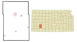 Location within Gray County and Kansas | |
 KDOT map of Gray County (legend) | |
| Coordinates: 37°49′48″N 100°27′14″W | |
| Country | United States |
| State | Kansas |
| County | Gray |
| Founded | 1880s |
| Incorporated | 1929 |
| Named for | John Ingalls |
| Area | |
| • Total | 0.25 sq mi (0.66 km2) |
| • Land | 0.25 sq mi (0.66 km2) |
| • Water | 0.00 sq mi (0.00 km2) |
| Elevation | 2,671 ft (814 m) |
| Population | |
| • Total | 306 |
| • Estimate (2019)[3] | 289 |
| • Density | 1,137.80/sq mi (439.58/km2) |
| Time zone | UTC-6 (CST) |
| • Summer (DST) | UTC-5 (CDT) |
| ZIP code | 67853 |
| Area code | 620 |
| FIPS code | 20-34225 [4] |
| GNIS ID | 0471650 [5] |
History
The first post office was established in May 1887 with the name Soule until May 1888.[7] The community was renamed for Kansas senator John James Ingalls.[8]
Ingalls was a candidate for county seat in the late 1880s, and once held the county offices.[9]
Geography
Ingalls is located at 37°49′48″N 100°27′14″W (37.829932, -100.453844).[10] According to the United States Census Bureau, the city has a total area of 0.26 square miles (0.67 km2), all of it land.[11]
Demographics
| Historical population | |||
|---|---|---|---|
| Census | Pop. | %± | |
| 1930 | 273 | — | |
| 1940 | 187 | −31.5% | |
| 1950 | 173 | −7.5% | |
| 1960 | 174 | 0.6% | |
| 1970 | 235 | 35.1% | |
| 1980 | 274 | 16.6% | |
| 1990 | 301 | 9.9% | |
| 2000 | 328 | 9.0% | |
| 2010 | 306 | −6.7% | |
| 2019 (est.) | 289 | [3] | −5.6% |
| U.S. Decennial Census | |||
2010 census
As of the census[2] of 2010, there were 306 people, 113 households, and 87 families residing in the city. The population density was 1,176.9 inhabitants per square mile (454.4/km2). There were 121 housing units at an average density of 465.4 per square mile (179.7/km2). The racial makeup of the city was 87.3% White, 0.3% African American, 0.3% Asian, 11.4% from other races, and 0.7% from two or more races. Hispanic or Latino of any race were 22.5% of the population.
There were 113 households, of which 41.6% had children under the age of 18 living with them, 62.8% were married couples living together, 7.1% had a female householder with no husband present, 7.1% had a male householder with no wife present, and 23.0% were non-families. 19.5% of all households were made up of individuals, and 5.3% had someone living alone who was 65 years of age or older. The average household size was 2.71 and the average family size was 3.10.
The median age in the city was 32.3 years. 27.1% of residents were under the age of 18; 12.2% were between the ages of 18 and 24; 29% were from 25 to 44; 22.6% were from 45 to 64; and 9.2% were 65 years of age or older. The gender makeup of the city was 50.3% male and 49.7% female.
2000 census
As of the census[4] of 2000, there were 328 people, 111 households, and 83 families residing in the city. The population density was 1,297.4 people per square mile (506.6/km2). There were 116 housing units at an average density of 458.8 per square mile (179.2/km2). The racial makeup of the city was 87.50% White, 0.30% Native American, 10.37% from other races, and 1.83% from two or more races. Hispanic or Latino of any race were 15.55% of the population.
There were 111 households, out of which 47.7% had children under the age of 18 living with them, 69.4% were married couples living together, 3.6% had a female householder with no husband present, and 25.2% were non-families. 22.5% of all households were made up of individuals, and 6.3% had someone living alone who was 65 years of age or older. The average household size was 2.95 and the average family size was 3.52.
In the city, the population was spread out, with 35.1% under the age of 18, 6.7% from 18 to 24, 33.5% from 25 to 44, 15.9% from 45 to 64, and 8.8% who were 65 years of age or older. The median age was 31 years. For every 100 females, there were 111.6 males. For every 100 females age 18 and over, there were 106.8 males.
The median income for a household in the city was $35,357, and the median income for a family was $38,036. Males had a median income of $36,563 versus $26,875 for females. The per capita income for the city was $14,898. About 14.6% of families and 15.5% of the population were below the poverty line, including 19.8% of those under age 18 and 27.8% of those age 65 or over.
References
- "2019 U.S. Gazetteer Files". United States Census Bureau. Retrieved July 24, 2020.
- "U.S. Census website". United States Census Bureau. Retrieved 2012-07-06.
- "Population and Housing Unit Estimates". United States Census Bureau. May 24, 2020. Retrieved May 27, 2020.
- "U.S. Census website". United States Census Bureau. Retrieved 2008-01-31.
- "US Board on Geographic Names". United States Geological Survey. 2007-10-25. Retrieved 2008-01-31.
- "2010 City Population and Housing Occupancy Status". U.S. Census Bureau. Retrieved March 6, 2011.
- "Kansas Post Offices, 1828-1961 (archived)". Kansas Historical Society. Archived from the original on 9 October 2013. Retrieved 10 June 2014.
- "Profile for Ingalls, Kansas". ePodunk. Retrieved 10 June 2014.
- Blackmar, Frank Wilson (1912). Kansas: A Cyclopedia of State History, Embracing Events, Institutions, Industries, Counties, Cities, Towns, Prominent Persons, Etc. Standard Publishing Company. pp. 937.
- "US Gazetteer files: 2010, 2000, and 1990". United States Census Bureau. 2011-02-12. Retrieved 2011-04-23.
- "US Gazetteer files 2010". United States Census Bureau. Archived from the original on 2012-01-25. Retrieved 2012-07-06.
- "Ingalls USD 477". USD 477. Retrieved 7 January 2017.
Further reading
External links
- City
- Schools
- USD 477, local school district
- Maps
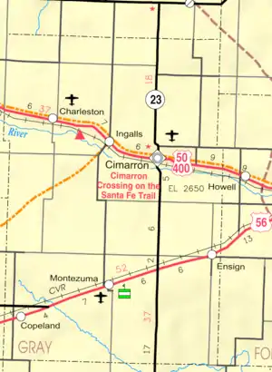
- Ingalls City Map, KDOT
Municipalities and communities of Gray County, Kansas, United States | ||
|---|---|---|
| Cities | 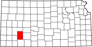 Map of Kansas highlighting Gray County | |
| Unincorporated communities | ||
| Townships | ||
| ||
