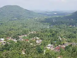
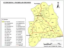
Ingiriya
Ingiriya (Sinhala: ඉංගිරිය; Tamil: இங்கிரிய) is a city in Kalutara District of Western Province, Sri Lanka, near the border with Sabaragamuwa Province. The city is the meeting point of the Rathnapura–Panadura, Ingiriya–Padukka and Ingiriya–Bulathsinhala roads.
Ingiriya
ඉංගිරිය இங்கிரிய | |
|---|---|
 Ingiriya | |
 Ingiriya Location Map | |
 Ingiriya Ingiriya Location Map | |
| Coordinates: 6°44′38″N 80°10′20″E | |
| Country | Sri Lanka |
| Province | Western Province |
| District | Kalutara District |
| Government | |
| • Electoral Division | Horana Polling Division |
| • Local Government | Horana Pradeshiya Sabha |
| • Divisional Secretariat | Ingiriya Divisional Secretariat |
| Elevation | 137 m (449 ft) |
| Population (2017) | |
| • Total | 56,074 |
| • Density | 252.66/km2 (654.4/sq mi) |
| Time zone | UTC+05:30 (SLT) |
| Postal Code | |
| Telephone code | 0094-3422 XXXXX |
| Website | www |
The city has an ethnic makeup of 89.7% Sinhalese and 10.1% Tamils, with less than 1% from other ethnicity. The 2001 census recorded a population of 45,726, rising to 56,074 in 2017.[1]
Location
Ingiriya can be accessed via the A8 (Rathnapura–Panadura) highway (33 km from Panadura, 35.8 km from Rathnapura), by the Padukka–Ingiriya Road (16.80 km from Padukka, 18.20 km from Meepe) or by the Egaloya–Ingiriya Road (11 km from Egaloya). Ingiriya is one of the borders of Kalutara District and Western Province. Ella, the next town after Ingiriya towards Rathnapura, belongs to Ratnapura District, Sabaragamuwa Province, and Padukka, the next town after Ingiriya towards the Padukka side, belongs to Colombo District.
Geography
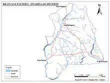
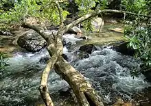
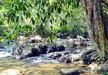
Ingiriya is 24 km (15 mi) from the coast and extends a further 8.8 km (5.5 mi) inland. It is mountainous, especially near the eastern border. The highest point is Madakada Giranchi Mountain, 355 m (1,165 ft) high. Eduragala Mountain is also over 210 m (690 ft) high. The eastern part contains scattered mountains over 150 m (490 ft) high. There are some similarly high mountains in the western part. Overall, 60% of the area is flat plains. The Kalu River flows along the southern border of Ingiriya and many streams flow into the Kalu River. The largest, Nambapana Stream, is in the east. Another river, the Mawak Oya, starts in the north and flows along the west side before connecting to the Kalu River in the south.
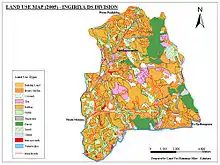
| Land Use | Area (km2) | Percentage % |
|---|---|---|
| Home garden | 2293 | 25% |
| Tea plantation | 582.81 | 06% |
| Rubber plantation | 3067.49 | 33% |
| Coconut plantation | 348.97 | 04% |
| Paddy plantation | 1132.32 | 12% |
| Other plantations | 278.78 | 03% |
| Forest | 801.64 | 09% |
| Scrub | 157.38 | 02% |
| Water bodies | 123.88 | 01% |
| Other land | 416.84 | 5% |
| Total | 9204 | 100% |
Climate
Ingiriya falls within the Low Country Wet Zone and has a medium climate, with 3,500 mm (140 in) to 4,500 mm (180 in) of annual rainfall, coming from both east–west monsoons (mid-November to January) and southwest monsoons (mid-May to mid-September).
| Month | Rainfall in mm | Days with rain | Average temperature in °C |
|---|---|---|---|
| January | 96 | 03 | 27.2 |
| February | 487 | 11 | 27.8 |
| March | 275 | 10 | 28.3 |
| April | 465 | 19 | 28.3 |
| May | 152 | 10 | 27.9 |
| June | 323 | 23 | 27.3 |
| July | 158 | 07 | 27.1 |
| August | 386 | 18 | 27.1 |
| September | 381 | 16 | 27.0 |
| October | 914 | 19 | 27.1 |
| November | 470 | 10 | 27.1 |
| December | 482 | 15 | 27.1 |
| Annual | 4589 | 161 | 27.5 |
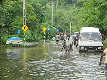
Flooding
Ingiriya is prone to flooding. The Kalu River overflows into the areas of Nambapana, Eastern and Western Urugala, Western Ingiriya town, Wagawatta, Kekulaliya, Western Poruwadanda and Dombagaskanda.[4]
Agriculture
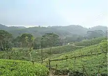
Ingiriya belongs to the Low Country Wet Agricultural Zone, so the land and climate is very suitable for cultivation. Tea, rubber, coconut and rice are the main cash crops. As of 2009 there are 5039 acres of rubber plantation, 1569 acres of tea plantation, 1500 acres of coconut plantation and 22 acres of rice paddies.
Administration
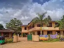
Ingiriya city, which is administered by the Horana Pradeshiya Sabha (Divisional Council), is a part of the Horana Polling Division. Notable government institutions in Ingiriya include:
- Ingiriya Divisional Secretariat
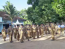
- Ingiriya Police Station
- Ingiriya District Hospital
- Ingiriya Medical Officer of Health
- Ingiriya Post Office
- Ingiriya Co-operative Services
- District Office of Ayurvedic Community Medical Health and Ayurvedic Central Dispensary
- Ceylon Electricity Board Ingiriya
- Horana Pradeshiya Sabha Ingiriya Sub Office
- Veterinary Office Ingiriya
The Ingiriya Divisional Secretariat office is the main administration institute managing Ingiriya City. Ingiriya was formerly a part of the Horana Divisional Secretariat. On August 14, 2000, 31 Grama Niladhari divisions were divided and assigned to Ingiriya Divisional Secretariat. This change occurred due to the large size of Horana division and the growth of the population.
Government health services and preventive medicine in Ingiriya are supplied by the Ingiriya Medical Officer of Health office and by Ingiriya District Hospital. Ingiriya Police Station, which was started in 1948, plays the major role in security. The main post office is an A grade Post Office. Other post offices are situated in surrounding areas. There is a fuel station run by Ingiriya Co-Operative Office and two private fuel stations at Handapangoda and Eduragala.
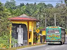
Transportation
Ingiriya is located along the Panadura and Rathnapura A8 Road. There are two bus stands in Ingiriya. All the buses that travel along A8 road park at the new bus stand. All other buses park at the old bus stand along Ingiriya–Padukka Road.
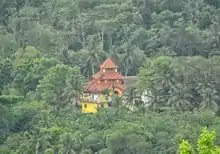
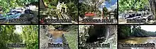
Landmarks
Nachchimale
Nachchimale (නාච්චිමලේ) is the most famous area of Ingiriya. It is reached by traveling about 1 mile (1.6 km) towards Padukka from Ingiriya. The Nachchimale port is a part of Nambapana Lake. Waterfalls and stone holes filled with clear water are a common scene. Thousands of foreigners and local visitors come to visit Nachchimale to bathe and have fun. However, this can lead to litter being strewn about. This has been a major problem to the environment and the residents.
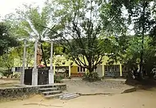
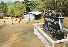
Madakada Aranya Senasanaya
Madakada Aranya Senasanaya is a monastery located about 1 mile (1.6 km) towards Padukka from Ingiriya. The history of this monastery goes back to 1940, when there were over 100 meditative monks living there. The new monastery was built by Rev. Ranwala Saddhatissa Thero in 1948. In ancient times, this area was a forest with caves. After the arrival of Saddahtissa Thero for his meditations, it became a forest monastery.
Madakada Aranya is one of the premier Vipassana meditation centers in the country. It has branches in places such as Navinna and Salgala. Presently, there are about sixteen resident monks and seven resident laymen practicing Vipassana meditation at any given time. The local community, which is primarily Buddhist, looks after the day-to-day needs of the devotees.
There are about 12–15 meditation caves here. The main cave has many Buddha statues and paintings and is decorated with flowers. The monastery is situated in a Natural Forest Reservation. A stream called Nachchimale flows through one boundary of the monastery. There are many local plants, birds, rare butterfly species, and wild animals in this environment.
Parei Thota
Parevi Thota (පරෙවිතොට) or Parethota (පරේතොට) is a scenic area along the Nambapana Stream that attracts many visitors. Small ports and waterfalls are located in the small stream situated near Parethota area. It is threatened by littering.
Bodhinagala Aranya Senasanaya
Bodhinagala Aranya Senasanaya is about 3 miles (4.8 km) from Ingiriya town. The Dombagaskanda Forest Reservation, where this place is situated, was named in 1955. The Kalu River flows through the southeast of this area, and the slope area is rich in herbal plants and southern wet zone plants. There are about 20 to 25 monks meditating in the caves in this Aranya Senasana. They come out from the caves only when they eat and then go back to the caves in the forest.
Bodhinagala Bird Sanctuary
This is a secondary lowland rainforest patch in the area of Ingiriya with a famous aranya senasanaya. The forest reserve consists of two mountains that are surrounded by villages. Inside the forest there are paved routes created for the Buddhist monks.
Hora Forest Reservation
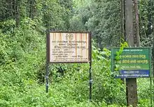
The Hora Forest Reservation is in the Kirigala area. It is said to have the largest number of hora trees in South Asia. It also has many rare plants.
Kura Uda Waterfall
Kura Uda Waterfall is situated in the middle stretch of the small stream starting from Giranchi Mountain in the Forest Reservation. The Government Forest Reservation in which this waterfall is situated is rich in rare wet zone plants and herbal plants. Many birds and animals native to this area live here.
Urugala Holombuwa
Before the British established a road system, goods were transported to coastal areas from Sabaragamuwa by river. Kalu River was a major river for this transportation. Urugala Holombuwa was used as an anchoring point for vessels and ferries transporting goods. This holombuwa is the biggest whirlpool at the place where Nambapana Stream connects with Kalu River. it has more space and consists of a huge rock pile. Because of this, boatsmen used this as a resting place.
History
As the boundary ("Ima") of the Sabaragamuwa Mountain Ranges ends at Ingiriya, it is said in the folklore that the name "Ingriya" was originally "Imagira".
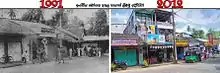
People have lived in this area for a long time, as shown in historical writings. A Portuguese income report written in 1599 shows that they collected revenue from nearby places like Munagama, Wagawatta, and Kekuladola. The present Rathnapura–Panadura road, which runs through Poruwadanda, has evidence of having been used for more than 186 years. A British doctor named John Dave travelled to Adams Peak in 1817 from Panadura via Horana, Rathnapura and Palabaddala. He described the beauty of the Ingiriya area as he travelled along this road. The main city was born in the beginning of plantation colonization by the British rulers. The Urugala and Nambapana areas of Ingiriya have a history which relates to the kings who ruled near Kalu River.
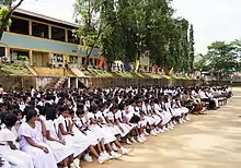
Schools
Ingiriya contains 22 schools controlled by the provincial council.
| School | Medium | G.N Division | Active Grade |
|---|---|---|---|
| Ingiriya Gamini Madya Maha Vidyalaya | Sinhala/English | 620C,Ingiriya North | 1 AB |
| Ingiriya Sri Sumanajothi Primary School | Sinhala | 620C,Ingiriya North | 3 |
| Urugala Sri Darmaloka Maha Vidyalaya | Sinhala | 619,Urugala East | 2 |
| Nambapana Kanishta Vidyalaya | Sinhala | 619A,Nambapana | 2 |
| Raigamwaththa Parakkramabahu Primary School | Sinhala | 620B,Raigamwatta | 3 |
| Kakulaliya Primary School | Sinhala | 618B,Kekulaliya | 3 |
| Handapangoda Maha Vidyalaya | Sinhala | 623B,Handapangoda West | 1 C |
| Sagara Palansuriya Maha Vidyalaya | Sinhala | 622,Handapangoda South | 1 C |
| Isipathana Kanishta Vidyalaya | Sinhala | 625,Arakawila | 2 |
| Maputugala Maha Vidyalaya | Sinhala | 621A,Rathmalgoda | 1 C |
| Menerigama Primary School | Sinhala | 625A,Menerigama | 3 |
| Batugampala Primary School | Sinhala | 624,Batugampala | 3 |
| Kalupahana Kanishta Vidyalaya | Sinhala | 618,Wagawatta | 2 |
| Manana Sri Ghanarathana Primary School | Sinhala | 620F,Dombagaskanda | 2 |
| Pelpitigoda Primary School | Sinhala | 622,Pelpitigoda | 3 |
| Kandanapitiya Primary School | Sinhala | 626,Kandanapitiya | 3 |
| Kurana Primary School | Sinhala | 627,Kurana South | 3 |
| Dharmaloka Primary School | Sinhala | 623B,Handapangoda West | 3 |
| Eduragala Tamil Primary School | Tamil | 620E,Eduragala | 3 |
| Raigamwaththa Tamil School | Tamil | 620B,Raigamwaththa | 2 |
| Raigamwaththa Saraswathi Tamil School | Tamil | 620G,Raigamwaththa | 3 |
| Perth Tamil School | Tamil | 618,Wagawatta | 3 |
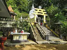
Religious Places
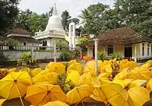
There are many places of worship in and around the city. Buddhist places of worship are most common, since Buddhists constitute the great majority in the area. There are some Hindu kovils serving the Tamil minority living in the plantation estates. There is also a Christian church in Ingiriya. The Population Reports show 89.4% Buddhist, 8.7% Hindu, 1.7% Christian and less than 1% other Religions in the Area.
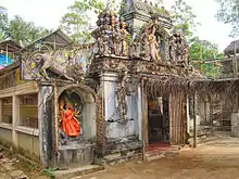
Temples
| Name | Address |
|---|---|
| Sri Devarakkitharamaya Temple | Wagawatta, Poruwadanda |
| Sri Sandagiri Temple | Arakawila, Handapangoda |
| Sri Wickramasinharamaya Temple | Maputugala, Poruwadanda |
| Sri Wijaya Bodhiraja Temple | Imagira, Ingiriya |
| Sri Thapodhanarama Temple | Pingodella, Urugala, Ingiriya |
| Sri Poorwarama Temple | Dombagaskanda, Ingiriya |
| Soliraja Temple | Ganethenna, Poruwadanda |
| Thilakaramaya Temple | Poruwadanda |
| Sri Sanghikaramaya Temple | Rathmalgoda, Poruwadanda |
| Ganeviharaya Temple | Handapangoda |
| Sri Sudharshanaramaya Temple | Manana, Poruwadanda |
| Sri Piyadassanaramaya Temple | Kurana, Kotigala, Handapangoda |
| Sri Sudharmaramaya Temple | Kekuladola, Batugampola |
| Sri Madurasama Temple | Nimalagama, Poruwadanda |
| Sri Gangathilaka Temple | Puhuwala |
| Sri Jayasooriya Temple | St.Peter's Colony, Ingiriya |
| Sri Nandarathanaramaya Temple | Pelpitigoda, Poruwadanda |
| Deepaloka Temple | Ingiriya |
| Sri Poorwaramaya Temple | Kandanapitiya, Bope, Padukka |
| Siri Nikethanaramaya Temple | Kekulaliya, Poruwadanda |
| Sri Wijayasunandaramaya Temple | Panangala Watta, Poruwadanda |
| Sri Sambodhi Temple | Arunagama, Poruwadanda |
| Sri Ruwanbodhi Temple | Boralugoda, Poruwadanda |
| Sri Sudhampaya Temple | Bodhirajagama, Ingiriya |
| Sri Isipathanaramaya Temple | Madakada, Bope, Padukka |
| Madakada Aranya Senasanaya | Madakada, Ingiriya |
| Bodhinagala Aranya Senasanaya | Dombagaskanda, Ingiriya |
| Nagalena Wiwekaramaya Temple | 20 Acres, Ingiriya |
| Sri Jinarathanaramaya Temple | Arakawila, Handapangoda |
| Sri Shailatalaramaya Temple | Wagawatta, Poruwadanda |
| Kemanandaramaya | Batugampola |
| Sri Sambodhi Aranya Senasanaya | Madakada |
| Sri Subodhi Meheni Aramaya | Kurana |
Kovil
| Name | Address |
|---|---|
| Sri Muththumari Amman Kovil | Wagawatta, Poruwadanda |
| Sri Kurunchi Mahamari Amman Kovil | Raigamwatta, Ingiriya |
| Ingiriya Sri Paththini Kovil | Ingiriya |
| Raigamwatta Sri Paththini Kovil | Raigamwatta, Ingiriya |
Notes
- Census and Statistics Report 2017
- Ingiriya Divisional Secretariat
- 2012 Annual Rainfall Report
- 2010 Ingiriya News Bulletin
- 2012 Horana Educational Zone Office
- Ingiriya Divisional Secretariat
References
- "Ingiriya Articles" (Article). Ingiriyacity.lk.
- "Ingiriya News Bulletin" (News). Ingiriyacity.lk.
- "Ingiriya Schools" (Article). Ingiriya Divisional Secretariat.
External links
| Wikimedia Commons has media related to Ingiriya. |