Inn of the Good Samaritan
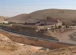
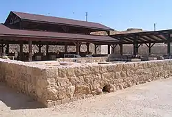
Khan al-Hatruri (Arabic: خان الحترورة), known in Western terms as the Inn of the Good Samaritan, is a ruined former caravanserai located at the road between Jerusalem and Jericho, 298 meters above sea level.[1] It now houses a museum of ancient mosaics and other archaeological findings from the Palestinian territories, the West Bank and the Gaza Strip.


It is sometimes confused with the nearby Khan al-Ahmar ("Red Caravaserai"), as the Good Samaritan Inn was sometimes also called by this name.[2]
Christian tradition
According to the Christian tradition, the site may have been the location of the event of the "Parable of the Good Samaritan" in the Gospel of Luke (Lk 10:25–37, specifically Lk 10:33). The association is made already by Jerome in 385 and continued through the centuries,[3] the British Mandate authorities adopting the name Good Samaritan Inn for the site.[2] There are few inns located between Jerusalem and Jericho, and Khan al-Hatruri is a plausible fit for the location of the story. After 1967 Israel developed the ruins as a tourist site officially called the "Good Samaritan Inn".[1] However, the identification as the "inn of the good Samaritan" is neither of Byzantine, nor of Crusader date, when pilgrims saw in the blood-coloured rocks rather the symbolic proof that this was the place where the traveller in the parable was beaten by the robbers.[4]
History
Israelites
The Iron Age Israelites called this area Maale Adumim, "Red Ascent" (Josh. 15:7, 18:17), due to the red rocks seen here, and it was part of their road between Jerusalem and Jericho.[4][3]
Late Roman and Byzantine periods
Eusebius, writing before 324 CE, mentions the Late Roman fort of Maledomni, whose traces have disappeared under the Templar castle of Maldoim.[4] The fort was already standing by 331, and around 400 it was garrisoned by Cohors I Salutaris, a Roman auxiliary unit commissioned with protecting the travellers.[3] Under the protection of the fortified place, a caravanserai was established.[4] In 385, St Jerome accompanied his benefactress, the Roman patrician Paula, on her pilgrimage to Jericho, and at this site recalled the parable of the merciful Samaritan, seemingly hinting at the existence there of a church and road station.[3] He introduces the interpretation that the name Adummim, derived from the Semitic root for blood and the colour red, stems from the blood shed there by the victims of road robbers, an idea later picked up by medieval authors.[3]
In the Early Byzantine period there seems to have been a fortress at the site (4th-5th century), replaced in the 6th century by a square-shaped inn, erected around a central courtyard, providing Christian pilgrims with rooms, water from a central cistern, and a large church for worship.[5]
Crusader period
The Templar castle of Maldoim (also Maledoim, Adumim, Castrum Dumi, Turris Rubea, Rubea Cisterna, Rouge Cisterne)[6] preserves the Israelite Hebrew name, Maale Adumim.[4] The castle is mentioned by Theoderic in 1172.[3] Its ruins stand at the hilltop dominating the khan, although now it is separated from it by the modern highway).[4] The protection offered by the castle had as a result the establishment of an inn, a remote precursor of the buildings we are seeing today.[4]
Ayyubid and Mamluk periods
After the Battle of Hattin in 1187, the castle, already deserted by the Knights Templar, was occupied by Saladin's troops.[3] A French author, writing around 1230, identifies the khan as the inn where "the Samaritan carried the man".[3] Later medieval authors start making a distinction between the khan and the castle.[3]
Felix Fabri wrote, after his 1483–84 pilgrimage to the Holy Land, about the ruined inn of which only the dangerously weathered four walls were still standing around a small well, a rare and important landmark along the steep ascent in an arid landscape.[7][8][3]
Ottoman period
In 1767 Giovanni Mariti, a man of culture but not so much of faith,[9] writes of the ruin on the hill that it "is called Castle of the Samaritan, after the nearby khan...".[3]
The Palestine Exploration Fund studied the site in 1873[3] and reported on the ruins of the inn:
"Khan Hathrurah — A Saracen hostel, standing on high ground, and just north of the present Jericho road. A few piers and some of the walls are still standing. On the opposite side of the road are two or three small caves, in one of which is a stone with an Arabic inscription. Cisterns, well-built and supported on arches, exist beneath the Khan, and contain water. North-east of this, on the highest part of the hill, are the remains of a strong fortress, which commands the road here, ascending through a narrow pass between walls of rock on the east. On the west also there is a winding ascent to the neighborhood of the Khan. The rock, especially on the west, is of a ruddy color like burnt brick, whence the title, Tal'at ed Damm, 'Ascent of Blood ', is applied to the whole hill, and sometimes to the castle on the summit".[10]
The Good Samaritan Museum of Mosaics
In 2010, a Museum of Mosaics was opened at the site. It was initiated by Yitzhak Magen, the Staff Officer for Archaeology at the Israeli Civil Administration for the West Bank. Magen discovered that the site had been rebuilt in several historical periods, and in every phase the site had apparently functioned as an inn for travellers. In the Byzantine period a church was also built at the site, suggesting its importance for early Christian pilgrims. The floor of the church was once decorated by a beautiful mosaic of geometric patterns that had largely disappeared in modern times. Magen decided that he and his team would restore the mosaic based on early photographs taken before the tiles had disappeared. After the successful restoration of the church's mosaic floor, it was decided to take the project further and create a mosaic museum there. The museum contains mosaic floors excavated all across the Palestinian territories of the West Bank and the Gaza Strip, with a wing dedicated to the history and customs of the Samaritans.[5][1][11]
References
- Rogoff, Mike. "Inn of the Good Samaritan, a Museum of Mosaics". Haaretz. Retrieved 6 June 2013.
- "ATQ/21/6 (letter to Deputy District Commissioner Jerusalem)". The Israel Antiquities Authority: The scientific Archive 1919-1948. 27 July 1928. Retrieved 22 August 2019.
It is reported to us on good authority that the people of Silwan claim ownership of this site upon which are the ruins of the monastery and church of St Euthymius situated a little to the South of the old road to Nabi Musa on a track branching from the road to Jericho at a point between the 13th and 14th kilometre stones. The place is known as the Khan al-Ahmar but is not to be confused with the Good Samaritan Inn known by the same name.
- Pringle, Denys (2016) [1994]. Barber, Malcolm (ed.). Cisterna Rubea (Qal'at ad-Damm). The Military Orders. I: Fighting for the Faith and Caring for the Sick. Routledge. pp. 153–162. ISBN 9780860784388. Retrieved 13 September 2020.
- Murphy-O'Connor, Jerome (2008). The Holy Land: An Oxford Archaeological Guide from Earliest Times to 1700. Oxford Archaeological Guides. Oxford: Oxford University Press. p. 452. ISBN 978-0-19-923666-4. Retrieved 30 July 2019.
- The website of the "Good Samaritan Museum"
- Pringle (1998), The Churches... volume II, p.454
- Pringle (1998), The Churches... volume II, p.454
- Felix Fabri (1893). Felix Fabri (Circa 1480-1483 A.D.). Vol. II (Part I). Translated by Stewart, Aubrey. London: Palestine Pilgrims' Text Society [publications, vol. 9]. pp. 68–69. Retrieved 13 September 2020.
- Bombardieri, Luca. Viaggi e studi del georgofilo fiorentino Giovanni Mariti nel Levante e a Cipro (1760-1768), in: Atti dei Georgofili, Accademia dei Georgofili, 2011. Abstract.
- Conder, Claude Reignier; Kitchener, Horatio Herbert (1881). The survey of western Palestine : memoirs of the topography, orography, hydrography, and archaeology. Committee of the Palestine exploration fund. pp. 207.
- The Good Samaritan Inn Mosaic Museum - Israel Nature and Parks Authority
Bibliography
- Conder, C.R.; Kitchener, H.H. (1883). The Survey of Western Palestine: Memoirs of the Topography, Orography, Hydrography, and Archaeology. 3. London: Committee of the Palestine Exploration Fund. (pp. 172, 207−209)
- Pringle, Denys (1997). Secular buildings in the Crusader Kingdom of Jerusalem: an archaeological Gazetter. Cambridge University Press. ISBN 0521-46010-7. (grid 1841/1361) (pp. 78−79)
- Pringle, Denys (1998). The Churches of the Crusader Kingdom of Jerusalem: L-Z (excluding Tyre). II. Cambridge University Press. ISBN 0-521-39037-0. (grid 1841/1386) (pp. 345− 346, 454)
See also
External links
| Wikimedia Commons has media related to Good Samaritan Museum. |
- The inn of the Good Samaritan, Bible walks
- Bolen, Todd. Jesus' Final Journey to Jerusalem, Jerusalem Perspective Online, 17 March 2004 & revised 2 December 2015. Accessed 6 September 2020.