Interstate 124
Interstate 124 (I-124) is an unsigned designation for a short segment of a four-lane controlled-access highway located in Chattanooga, Tennessee. During periods where this two-mile-long (3.2 km) segment of U.S. Route 27 (US 27) has been signed as I-124, it has served as a spur route of I-24 to downtown Chattanooga. The road segment has not been signed as I-124 since the late 1980s[2] (it is marked on overhead signs and mile markers as US 27), and the Tennessee Department of Transportation official map no longer designates it as I-124, but some DOT publications still make reference to the designation.[3]
| ||||
|---|---|---|---|---|
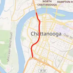
I-124 highlighted in red | ||||
| Route information | ||||
| Auxiliary route of I-24 | ||||
| Maintained by TDOT | ||||
| Length | 1.97 mi[1] (3.17 km) | |||
| Existed | 1960–present | |||
| Major junctions | ||||
| South end | ||||
| North end | ||||
| Location | ||||
| Counties | Hamilton | |||
| Highway system | ||||
| ||||

Route description
The US 27 freeway diverges from I-24 just before the Moccasin Bend in the Tennessee River, continues north through downtown Chattanooga, and then across the Tennessee River as a limited-access freeway on the P. R. Olgiati Bridge. The river is the point at which the I-124 designation ends. After crossing the river, the freeway continues under the US 27 designation for another 30 miles (48 km) (beyond which the spur continues under the Tennessee State Route 111 designation for a further 20 miles (32 km)).
The entire length of I-124 is part of the National Highway System, a system of routes determined to be the most important for the nation's economy, mobility, and defense.[4]
History
The route that is now I-124 was proposed in the 1950s by then-mayor of Chattanooga P.R. "Rudy" Olgiati to provide a secondary access across the Tennessee River and relieve congestion which had developed on the Market Street and Walnut Street Bridges.[5] The section of highway between Martin Luther King Jr. Boulevard was built between 1955 and 1959.[5] The southern portion, located between I-24 and Martin Luther King Jr. Boulevard, was built between 1961 and 1963, when that corresponding section of I-24 was built. The interchange with I-24, known as the "Big Scramble," was reworked in the late 1980s and early 1990s, and the I-124 signage was removed at this time.[2]
A major reconstruction project commenced in December 2015 to widen and modernize I-124, which will reconstruct all interchanges, provide adequate shoulders and median divider, widen the route to six lanes, and remove the s-curve at the 4th street interchange. Originally scheduled to be completed by July 2019, the project ran into multiple setbacks, which delayed the completed until January 2021.[6]
Exit list
The entire route is in Chattanooga, Hamilton County.
| mi | km | Exit | Destinations | Notes | ||
|---|---|---|---|---|---|---|
| 0.0 | 0.0 | — | Southern terminus; southern end of US 27 concurrency; southbound exit and northbound entrance | |||
| 0.5 | 0.80 | 1A | Carter Street, W Main Street | Partial interchange consisting of an exit from the northbound lanes and entrance to the southbound lanes | ||
| 0.7– 1.2 | 1.1– 1.9 | 1A/1B/1C | Martin Luther King Boulevard (SR 316), 6th Street, 4th Street (SR 389)– Downtown | Signed as exit 1B (Martin Luther King Boulevard) and 1C (4th Street) from the northbound lanes; signed as exits 1B-C (4th Street, 6th Street, W Martin Luther King Boulevard) and exit 1A (E Martin Luther King Boulevard) from southbound lanes; no northbound access to 6th Street; unsigned SR 316 and SR 389. | ||
| 1.7 | 2.7 | — | Continuation as US 27 at the Tennessee River, on the P. R. Olgiati Bridge | |||
1.000 mi = 1.609 km; 1.000 km = 0.621 mi
| ||||||
See also
 United States portal
 U.S. Roads portal
References
- DeSimone, Tony (April 6, 2011). "Table 2: Auxiliary Routes of the Dwight D. Eisenhower National System Of Interstate and Defense Highways as of October 31, 2002". FHWA Route Log and Finder List. Federal Highway Administration. Retrieved March 4, 2010.
- Jolley, Harmon (July 9, 2004). "Where Do Our Interstate Highways Terminate?". The Chattanoogan. Chattanooga, Tennessee. Retrieved 16 January 2018.
- Staff (May 1, 2007). "Fiscal Years 2008-2010 Transportation Improvement Program". Tennessee Department of Transportation. Retrieved March 4, 2012.
- National Highway System: Chattanooga, TN--GA (PDF) (Map). Federal Highway Administration. May 10, 2019. Retrieved August 15, 2019.
- "Why did they name it the "Ol' Johnny Bridge?" | David Carroll's Chattanooga Radio and TV". www.chattanoogaradiotv.com. Retrieved 2015-10-06.
- "US 27 Reconstruction in Downtown Chattanooga". TDOT. Tennessee Department of Transportation. October 16, 2015. Retrieved April 21, 2018.