List of Interstate Highways
There are 70 primary Interstate Highways in the Interstate Highway System, a network of freeways in the United States. They are assigned one- or two-digit route numbers, whereas their associated "auxiliary" Interstate Highways receive three-digit route numbers. Typically, odd-numbered Interstates run south-north, with lower numbers in the west and higher numbers in the east; even-numbered Interstates run west-east, with lower numbers in the south and higher numbers in the north. Highways whose route numbers are divisible by 5 usually represent major coast-to-coast or border-to-border routes (ex. I-10 travels from Santa Monica, California, to Jacksonville, Florida, traveling from the Pacific to Atlantic oceans). Additionally, auxiliary highways have their numbering system where a different number prefixes the number of its parent highway.
| Dwight D. Eisenhower National System of Interstate and Defense Highways | |
|---|---|
  Highway shield for Interstate 90 and the Eisenhower Interstate System | |
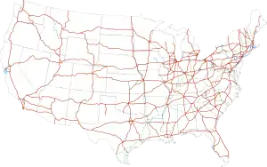 Interstate Highways in the 48 contiguous states | |
| System information | |
| Formed | June 29, 1956[1] |
| Highway names | |
| Interstates | Interstate X (I-X) |
| System links | |
Five route numbers are duplicated in the system, though the corresponding highways are separated by state lines which prevent confusion. The main list that discusses the primary Interstate Highways in the contiguous United States is followed by sections regarding Alaska, Hawaii, and Puerto Rico.
Contiguous United States
There are 70 primary Interstate Highways listed in the table below.
| Number | Length (mi)[2] | Length (km) | Southern or western terminus | Northern or eastern terminus | Formed | Removed | Notes |
|---|---|---|---|---|---|---|---|
| 46.8 | 75.3 | US 83 in Peñitas, Texas | I-69E/US 77/US 83 in Harlingen, Texas | 2013 | current | Texas only Associated routes: none | |
| 132.3 | 212.9 | I-275 in Tampa, Florida | I-95/SR 400 Daytona Beach, Florida | 1959 | current | Florida only Associated routes: none | |
| 1,381.29 | 2,222.97 | Fed. 1 at Mexican border in San Ysidro, California | BC 99 at Canadian border in Blaine, Washington | 1956 | current | Serves three states: California, Oregon, Washington Associated routes: I-105, I-205, I-405, I-505, I-605, I-705, I-805; Future: I-305, I-905 | |
| 348.25 | 560.45 | Sunset Cliffs Boulevard/Nimitz Boulevard in San Diego, California | I-10 in Casa Grande, Arizona | 1964 | current | Serves two states: California, Arizona Associated routes: none | |
| 2,460.34 | 3,959.53 | SR 1 in Santa Monica, California | I-95/US 17/SR 228 in Jacksonville, Florida | 1957 | current | Serves eight states: California, Arizona, New Mexico, Texas, Louisiana, Mississippi, Alabama, Florida Associated routes: I-110, I-210, I-310, I-410, I-510, I-610, I-710, I-910 | |
| 22.845 | 36.765 | US 93 at Arizona state line near Boulder City, Nevada | I-215/I-515/US 93/US 95/SR 564 in Henderson, Nevada | 2017 | current | Nevada only; planned extension north and south Associated routes: none | |
| 85.59 | 137.74 | I-10 in Baton Rouge, Louisiana | I-10/I-59 in Slidell, Louisiana | 1967 | current | Louisiana only Associated routes: none | |
| 25.1 | 40.4 | US 190/SH 9 in Copperas Cove, Texas | I-35 in Belton, Texas | 2017 | current | Texas only; planned extension east and west Associated routes: none | |
| 1,433.52 | 2,307.03 | I-8/SR 15 in San Diego, California | Hwy. 4 at Canadian border in Sweetgrass, Montana | 1957 | current | Serves six states: California, Nevada, Arizona, Utah, Idaho, Montana Associated routes: I-115, I-215, I-315, I-515 | |
| 166.81 | 268.45 | I-75 in Macon, Georgia | SR 404 and Montgomery Street/Martin Luther King Jr. Boulevard in Savannah, Georgia | 1966 | current | Georgia only Associated route: I-516 | |
| 145.76 | 234.58 | I-10 in Phoenix, Arizona | I-40/SR 89A in Flagstaff, Arizona | 1961 | current | Arizona only Associated routes: none | |
| 63.35 | 101.95 | Fed. 15 at Mexican border in Nogales, Arizona | I-10 in Tucson, Arizona | 1972 | current | Arizona only Associated routes: none Uses kilometers instead of miles | |
| 1,539.38 | 2,477.39 | I-10 at Scroggins Draw, Texas | I-95 in Florence, South Carolina | 1957 | current | Serves six states: Texas, Louisiana, Mississippi, Alabama, Georgia, South Carolina Associated routes: I-220, I-520, I-820 | |
| 202.22 | 325.44 | I-269/US 78 near Byhalia, Mississippi | I-65/US 31 in Birmingham, Alabama | 2012 | current | Serves two states: Mississippi, Alabama Planned associated routes: I-222, I-422 | |
| 316.36 | 509.13 | I-57 in Pulley's Mill, Illinois | I-75 in Chattanooga, Tennessee | 1962 | current | Serves four states: Illinois, Kentucky, Tennessee, Georgia Associated route: I-124 | |
| 1,061.67 | 1,708.59 | I-10/US 85/US 180 in Las Cruces, New Mexico | I-90/US 87 in Buffalo, Wyoming | 1957 | current | Serves three states: New Mexico, Colorado, Wyoming Associated route: I-225 | |
| 304.64 | 490.27 | US 11W/US 23 in Kingsport, Tennessee | US 17 in Charleston, South Carolina | 1960 | current | Serves three states: Tennessee, North Carolina, South Carolina Associated routes: I-126, I-526 | |
| 124.13 | 199.77 | US 87/Loop 289 in Lubbock, Texas | I-40/US 87/US 287 in Amarillo, Texas | 1969 | current | Texas only Associated routes: none | |
| 755.51 | 1,215.88 | I-35/I-70/US 24/US 40/US 71 in Kansas City, Missouri | US 81 and PTH 29 at Canadian border in Pembina, North Dakota | 1958 | current | Serves four states: Missouri, Iowa, South Dakota, North Dakota Associated routes: I-129, I-229 | |
| 366.76 | 590.24 | I-20 in Fort Worth, Texas | I-40/US 65/US 67/US 167 in North Little Rock, Arkansas | 1957 | current | Serves two states: Texas, Arkansas Associated routes: I-430, I-530, I-630 | |
| 1,568.38 | 2,524.06 | US 83/SH 359/BS I-35 and MX-85 at Mexican border in Laredo, Texas | MN 61/LSCT/26th Avenue in Duluth, Minnesota | 1956 | current | Serves six states: Texas, Oklahoma, Kansas, Missouri, Iowa, Minnesota Associated routes: I-35E, I-35W, I-135, I-235, I-335, I-435, I-535, I-635 | |
| 143.00 | 230.14 | US 181 in Corpus Christi, Texas | I-35/US 281 in San Antonio, Texas | 1959 | current | Texas only Associated routes: none | |
| 306.14 | 492.68 | I-55 in Normal, Illinois | WIS 29/US 51 in Wausau, Wisconsin | 1984 | current | Serves two states: Illinois, Wisconsin Associated routes: none | |
| 2,556.61 | 4,114.46 | I-15 in Barstow, California | US 117/NC 132 in Wilmington, North Carolina | 1964 | current | Serves eight states: California, Arizona, New Mexico, Texas, Oklahoma, Arkansas, Tennessee, North Carolina Associated routes: I-140, I-240, I-440, I-540, I-640, I-840 | |
| 175 | 282 | I-94/US 41 in Russell, Illinois | I-43 in Howard, Wisconsin | 2015 | current | Serves two states: Illinois, Wisconsin Associated routes: none | |
| 191.55 | 308.27 | I-39/I-90 in Beloit, Wisconsin | I-41/US 41/US 141 in Howard, Wisconsin | 1981 | current | Wisconsin only Associated routes: none | |
| 636.69 | 1,024.65 | US 82/US 277/US 281/US 287 in Wichita Falls, Texas | I-70 in St. Louis, Missouri | 1958 | current | Serves three states: Texas, Oklahoma, Missouri Associated routes: I-244, I-444 | |
| 284.91 | 458.52 | SH 87 in Galveston, Texas | I-30/US 67/US 75 in Dallas, Texas | 1971 | current | Texas only Associated route: I-345 | |
| 528.02 | 849.77 | I-10 in Lafayette, Louisiana | I-435/I-470/US 50/US 71 in Kansas City, Missouri | 1984 | current | Serves three states: Louisiana, Arkansas, Missouri Associated routes: none | |
| 964.25 | 1,551.81 | I-10 in LaPlace, Louisiana | US 41 in Chicago, Illinois | 1960 | current | Serves six states: Louisiana, Mississippi, Tennessee, Arkansas, Missouri, Illinois Associated routes: I-155, I-255, I-355; I-555 | |
| 386.12 | 621.40 | I-55 in Miner, Missouri | I-94 in Chicago, Illinois | 1965 | current | Serves two states: Missouri, Illinois; planned in 1 more: Arkansas Associated routes: none | |
| 445.23 | 716.53 | I-10/I-12 in Slidell, Louisiana | I-24 in Wildwood, Georgia | 1960 | current | Serves four states: Louisiana, Mississippi, Alabama, Georgia Associated routes: I-359, I-459, I-759 | |
| 963.52 | 1,550.64 | I-70/US 61 in Wentzville, Missouri | I-264/I-664 in Chesapeake, Virginia | 1961 | current | Serves six states: Missouri, Illinois, Indiana, Kentucky, West Virginia, Virginia Associated routes: I-264, I-464, I-564, I-664 | |
| 887.30 | 1,427.97 | I-10 in Mobile, Alabama | US 12/US 20 in Gary, Indiana | 1958 | current | Serves four states: Alabama, Tennessee, Kentucky, Indiana Associated routes: I-165, I-265, I-465, I-565, I-865 | |
| 76.28 | 122.76 | I-81 in Front Royal, Virginia | US 29 in Washington, D.C. | 1961 | current | Serves DC and one state: Virginia Associated routes: None, had one proposed auxiliary route, I-266, but was cancelled due to freeway revolts. | |
| 113.15 | 182.10 | I-79 in Morgantown, West Virginia | I-70 in Hancock, Maryland | 1991 | current | Serves two states: West Virginia, Maryland Associated routes: None | |
| 841.30 | 1,353.94 | I-69E/US 77 & I-69W/US 59 in Victoria, Texas (future) | Hwy 402 at Canadian border in Port Huron, Michigan | 1957 | current | Unfinished Texas section: Rosenberg (US-59/Spur 529) to Splendora (US 59/Mandell Road) Unfinished Mississippi-Tennessee section: Banks, Mississippi (MS 304/MS 713) to Frayser, Tennessee (US 51/TN 3) Unfinished Indiana section: Martinsville, Indiana to Indianapolis, Indiana Serves six states: Texas, Mississippi, Tennessee, Kentucky, Indiana, Michigan. Planned/started in 2 more: Louisiana, Arkansas Associated routes: I-69C, I-69E, I-69W, I-169, I-269, I-369, I-469; Planned: I-169 in Tennessee, I-369 in Kentucky | |
| 2,150.57 | 3,461.01 | I-15 in Cove Fort, Utah | Park and ride in Baltimore, Maryland | 1956 | current | Serves 10 states: Utah, Colorado, Kansas, Missouri, Illinois, Indiana, Ohio, West Virginia, Pennsylvania, Maryland Associated routes: I-170, I-270, I-370, I-470, I-670 | |
| 345.57 | 556.14 | I-64 in Louisville, Kentucky | I-90 in Cleveland, Ohio | 1959 | current | Serves two states: Kentucky, Ohio Associated routes: I-271, I-471 | |
| 179.29 | 288.54 | US 61 in Hannibal, Missouri | Church Street and University Avenue in Champaign, Illinois | 1970 | current | Serves two states: Missouri, Illinois Associated route: I-172 | |
| 101.10 | 162.70 | US 220 near Stokesdale, North Carolina | I‑74 in Randleman, North Carolina | 1997 | current | North Carolina only Associated routes: none | |
| 488.83 | 786.70 | I-80 in Bettendorf, Iowa | US 74/NC 41 near Lumberton, North Carolina | 1974 | current | Serves five states: Iowa, Illinois, Indiana, Ohio, North Carolina Associated routes: I-474 | |
| 1,786.47 | 2,875.04 | SR 826/SR 916/SR 924 in Miami Lakes, Florida | Canadian border at Sault Ste. Marie, Michigan | 1958 | current | Serves six states: Florida, Georgia, Tennessee, Kentucky, Ohio, Michigan Associated routes: I-175, I-275, I-375, I-475, I-575, I-675 | |
| 186.48 | 300.11 | I-70 at Denver, Colorado | I-80 at Big Springs, Nebraska | 1975 | current | Serves two states: Colorado, Nebraska Associated routes: none | |
| 435.66 | 701.13 | I-71 in Westfield Center, Ohio | I-295 at Bellmawr, New Jersey | 1964 | current | Serves three states: Ohio, Pennsylvania, New Jersey Associated routes: I-176, I-276, I-376, I-476, I-676; Future: I-576 | |
| 610.10 | 981.86 | I-26 in Columbia, South Carolina | I-90 in Cleveland, Ohio | 1958 | current | Serves five states: South Carolina, North Carolina, Virginia, West Virginia, Ohio Associated route: I-277 | |
| 146.28 | 235.41 | I-81 at Jonestown, Pennsylvania | Canal Street in New York City | 1957 | current | Serves three states: Pennsylvania, New Jersey, New York Associated routes: I-278, I-478, I-678, I-878 | |
| 343.46 | 552.75 | I-77 in Charleston, West Virginia | PA 5 in Erie, Pennsylvania | 1967 | current | Serves two states: West Virginia, Pennsylvania Associated routes: I-279, I-579 | |
| 2,899.59 | 4,666.44 | US 101 in San Francisco, California | I-95 in Teaneck, New Jersey | 1956 | current | Serves 11 states: California, Nevada, Utah, Wyoming, Nebraska, Iowa, Illinois, Indiana, Ohio, Pennsylvania, New Jersey Associated routes: I-180, I-238, I-280, I-380, I-480, I-580, I-680, I-780, I-880, I-980 | |
| 855.02 | 1,376.02 | I-40 in Dandridge, Tennessee | Canadian border at Wellesley Island, New York | 1961 | current | Serves six states: Tennessee, Virginia, West Virginia, Maryland, Pennsylvania, New York Associated routes: I-381, I-481, I-581, I-781 | |
| 143.58 | 231.07 | I-90 in Ellensburg, Washington | I-84 in Hermiston, Oregon | 1957 | current | Serves two states: Washington, Oregon Associated route: I-182 | |
| 85.03 | 136.84 | President Street and Fayette Street in Baltimore, Maryland | I-81 in Harrisburg, Pennsylvania | 1959 | current | Serves two states: Maryland, Pennsylvania Associated route: I-283 | |
| 769.62 | 1,238.58 | I-5 in Portland, Oregon | I-80 in Echo, Utah | 1980 | current | Serves three states: Oregon, Idaho, Utah Associated route: I-184 | |
| 232.71 | 374.51 | I-81 in Scranton, Pennsylvania | I-90 in Sturbridge, Massachusetts | 1963 | current | Serves four states: Pennsylvania, NY, Connecticut, Massachusetts Associated routes: I-384, I-684 | |
| 666.05 | 1,071.90 | I-65 in Montgomery, Alabama | I-95 in Petersburg, Virginia | 1958 | current | Serves five states: Alabama, Georgia, South Carolina, North Carolina, Virginia Associated routes: I-185, I-285, I-385, I-485, I-585, I-785, I-985; Planned: I-685 | |
| 62.85 | 101.15 | I-84 near Declo, Idaho | I-15 in Chubbuck, Idaho | 1980 | current | Idaho only Associated routes: none | |
| 223.39 | 359.51 | I-90 near North East, Pennsylvania | NY 17/NY 79 in Windsor, New York | 1999 | current | Unfinished New York section: Waverly (NY 34) to Kirkwood (I-81) Serves two states: Pennsylvania, New York Associated routes: none | |
| 12.9 | 20.8 | I-440/US 64/US 264 in Raleigh, North Carolina | US 64/US 264 in Wendell, North Carolina | 2017 | current | North Carolina only Associated routes: None, will eventually have one spur route, I-587; shortest Interstate highway in contiguous United States | |
| 333.49 | 536.70 | I-278 in New York City | A-15 at Canadian border in Champlain, New York | 1957 | current | New York only Associated routes: I-287, I-587, I-787 | |
| 140.6 | 226.3 | I-80/IL 92 near East Moline, Illinois | I-290/IL 110 in Hillside, Illinois | 1987 | current | Illinois only Associated routes: none | |
| 117.75 | 189.50 | I-81 in Binghamton, New York | I-90 in Schenectady, New York | 1968 | current | New York only Associated routes: none | |
| 191.12 | 307.58 | I-93/SR 3A in Bow, New Hampshire | Route 133/Future A-35 at Canadian border in Highgate, Vermont | 1960 | current | Serves two states: New Hampshire, Vermont Associated route: I-189 | |
| 3,020.44 | 4,860.93 | SR 519/4th Avenue/Edgar Martinez Drive in Seattle, Washington | MA 1A in Boston, Massachusetts | 1956 | current | Serves 13 states: Washington, Idaho, Montana, Wyoming, South Dakota, Minnesota, Wisconsin, Illinois, Indiana, Ohio, Pennsylvania, New York, Massachusetts Associated routes: I-190, I-290, I-390, I-490, I-590, I-690, I-790, I-890, I-990 Longest Interstate highway | |
| 290.37 | 467.31 | I-95 in New Haven, Connecticut | A-55 at Canadian border in Derby Line, Vermont | 1958 | current | Serves three states: Connecticut, Massachusetts, Vermont Associated routes: I-291, I-391, I-691 | |
| 189.95 | 305.69 | I-95/US 1 in Canton, Massachusetts | I-91 in St. Johnsbury, Vermont | 1957 | current | Serves three states: Massachusetts, New Hampshire, Vermont Associated routes: I-293, I-393 | |
| 1,585.20 | 2,551.13 | I-90 in Lockwood, Montana | Highway 402 at Canadian border in Port Huron, Michigan | 1956 | current | Serves seven states: Montana, North Dakota, Minnesota, Wisconsin, Illinois, Indiana, Michigan Associated routes: I-194, I-294, I-394, I-494, I-694, I-794, I-894 | |
| 1,908.48 | 3,071.40 | US 1 in Miami, Florida | NB 95 at Canadian border in Houlton, Maine | 1957 | current | Serves DC and 15 states: Florida, Georgia, South Carolina, North Carolina, Virginia, Maryland, Delaware, Pennsylvania, New Jersey, New York, Connecticut, Rhode Island, Massachusetts, New Hampshire, Maine Associated routes: I-195, I-295, I-395, I-495, I-595, I-695, I-795, I-895 Longest primarily north-south Interstate highway | |
| 192.06 | 309.09 | US 31 in Norton Shores, Michigan | I-75 in Detroit, Michigan | 1959 | current | Michigan only Associated routes: I-196, I-296, I-496, I-696 | |
| 17.62 | 28.36 | US 50 in Annapolis, Maryland | I-695/I-895 in Glen Burnie, Maryland | 1987 | current | Maryland only Associated routes: None, had 2 auxiliary routes planned, I-197 and I-297, but they were replaced by I-595 and MD Route 3. | |
| 98.34 | 158.26 | I-70/I-76 in Bedford, Pennsylvania | I-86/NY 17 in Painted Post, New York | 1998 | current | Unfinished Pennsylvania section: Bellefonte, Pennsylvania (I-80) to New York state line near Lawrenceville, Pennsylvania (US 15) Serves two states: Pennsylvania, New York Associated routes: none |
Other jurisdictions
In addition to the 48 contiguous states, Interstate Highways are found in Hawaii, Alaska, and Puerto Rico. The Federal Highway Administration funds four routes in Alaska and three routes in Puerto Rico under the same program as the rest of the Interstate Highway System. However, these routes are not required to meet the same standards as the mainland routes:
Highways on the Interstate System in Alaska and Puerto Rico shall be designed in accordance with such geometric and construction standards as are adequate for current and probable future traffic demands and the needs of the locality of the highway.[3]
Hawaii
The Interstate Highways in the island of Oʻahu, Hawaii are signed with the standard Interstate Highway shield, with the letter "H-" prefixed before the number. They are fully controlled-access routes built to the same standards as the mainland Interstate Highways.
| Number | Length (mi)[2] | Length (km) | Southern or western terminus | Northern or eastern terminus | Formed | Removed | Notes | |
|---|---|---|---|---|---|---|---|---|
| 27.16 | 43.71 | Route 93 in Kapolei | Route 72 in Honolulu | 1959 | current | Associated route: H-201 | ||
| 8.33 | 13.41 | H-1 in Pearl City | Route 99 in Wahiawa | 1976 | current | |||
| 15.32 | 24.66 | H-1 & H-201 in Halawa | Marine Corps Base Hawaii | 1997 | current | |||
| H-4 | 6.5 | 10.5 | — | — | — | — | Was to have provided relief around the congested areas of H-1, but the idea was not popular and was never built. | |
| ||||||||
Alaska
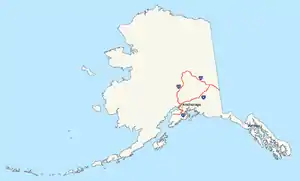
Alaska's Interstate Highways are unsigned as such, although they all have state highway numbers that do not match the Interstate Highway numbers.[4]
| Number | Length (mi)[2] | Length (km) | Southern or western terminus | Northern or eastern terminus | Formed | Removed | Notes |
|---|---|---|---|---|---|---|---|
| 408.23 | 656.98 | Anchorage | Canadian border in Alcan Border | 1976 | current | Glenn Highway, Richardson Highway, Tok Cut-Off, Alaska Highway[5][6][7][8] | |
| 202.18 | 325.38 | Tok | Fairbanks | 1976 | current | Alaska Highway, Richardson Highway[6][7][8] | |
| 148.12 | 238.38 | Anchorage | Soldotna | 1976 | current | Seward Highway, Sterling Highway[5][7][8] | |
| 323.69 | 520.93 | Gateway, near Palmer | Fairbanks | 1976 | current | Parks Highway[5][6][7][8] |
Puerto Rico
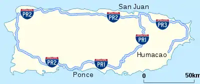
Like Alaska, Puerto Rico signs its Interstate Highways as territorial routes, and the numbers do not match their official Interstate Highway designations. Many of the territory's routes are freeway-standard toll roads.[9]
| Number | Length (mi)[2] | Length (km) | Southern or western terminus | Northern or eastern terminus | Formed | Removed | Notes |
|---|---|---|---|---|---|---|---|
| 71.08 | 114.39 | PR-2 in Ponce | PR-2 in San Juan | 1953 | current | Follows PR-52 | |
| 138.13 | 222.30 | PR-1 in Ponce | PR-3 in San Juan | 1953 | current | Follows PR-22 | |
| 65.27 | 105.04 | PR-3 in Humacao | PR-2 in San Juan | 1953 | current | Follows PR-66 |
In popular culture
The title of interactive fiction I-0 refers to the fictional "Interstate Zero".[10] A fictional highway is depicted in the movie Interstate 60.
See also
 U.S. Roads portal
References
- Weingroff, Richard F. (Summer 1996). "Federal-Aid Highway Act of 1956, Creating the Interstate System". Public Roads. Washington, DC: Federal Highway Administration. 60 (1). Retrieved March 16, 2012.
- Adderley, Kevin (January 30, 2019). "Table 1: Main Routes of the Dwight D. Eisenhower National System of Interstate and Defense Highways as of December 31, 2017". Route Log and Finder List. Federal Highway Administration.
- Staff. "FHWA Route Log and Finder List". Federal Highway Administration. Retrieved May 24, 2007.
- Voss, Oscar. "Alaska Roads: Interstate ends photos". Retrieved May 24, 2007.
- Witt, Jennifer W. (2010). Annual Traffic Volume Report (PDF) (Report) (2008-2009-2010 ed.). Alaska Department of Transportation & Public Facilities. Archived from the original (PDF) on March 30, 2014. Retrieved March 15, 2012.
- Birkholz, Ethan (2010). Annual Traffic Volume Report (PDF) (Report) (2008-2009-2010 ed.). Alaska Department of Transportation & Public Facilities. Archived from the original (PDF) on April 17, 2014. Retrieved May 31, 2012.
- Staff. "Dwight D. Eisenhower Interstate Routes Statewide" (PDF). Federal Highway Administration. Retrieved May 31, 2012.
- Staff. "Alaska Department of Transportation and Public Facilities Routes by Description: CDS Route Numbers as of 28 October 2008" (PDF). Federal Highway Administration. Retrieved May 31, 2012.
- Voss, Oscar. "Puerto Rico road photos". Retrieved May 24, 2007.
- "I-0". Interactive Fiction Database. Retrieved February 1, 2016.
External links
 Geographic data related to List of Interstate Highways at OpenStreetMap
- Alaska Roads - Interstate ends photos
- Puerto Rico road photos
- The Dwight D. Eisenhower National System of Interstate and Defense Highways Route Log and Finder List
- 3-digit Interstate Highways
| Signed | |
|---|---|
| Unsigned | |
| Lists | |
| Other | |
Major Interstates highlighted | |