Interstate 77 in Virginia
Interstate 77 (I-77) in the U.S. state of Virginia is a 67-mile (108 km) north–south Interstate Highway serving Hillsville, Wytheville, and Bland. Running parallel to U.S. Route 52 (US 52), I-77 passes through the Big Walker Mountain Tunnel and East River Mountain Tunnel, the latter on the West Virginia state line and one of only two land vehicular tunnels to cross a state line.[4]
| ||||
|---|---|---|---|---|
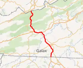
I-77 highlighted in red | ||||
| Route information | ||||
| Maintained by VDOT | ||||
| Length | 66.27 mi[1][2][3] (106.65 km) | |||
| Existed | 1972–present | |||
| Major junctions | ||||
| South end | ||||
| North end | ||||
| Location | ||||
| Counties | Carroll, Wythe, Bland | |||
| Highway system | ||||
| ||||

Route description
_in_North_Gap%252C_Bland_County%252C_Virginia.jpg.webp)
Interstate 77 enters Virginia near Mount Airy, while the highway continues south into North Carolina concurrently with a segment of the unfinished Interstate 74. The first exit is a folded diamond interchange with Route 620.[5] The route continues northeast towards Fancy Gap and passes under the Blue Ridge Parkway, with access to it and the town provided by a diamond interchange with Route 775, which has a connection to U.S. Route 52.
Continuing northwest, the expressway reaches another diamond interchange with U.S. Route 58 (Carrollton Pike). The route has another interchange with Route 620 before folding onto Interstate 81.
The route begins a wrong-way concurrency with Interstate 81 and U.S. Route 11, with the northbound direction co-signed with southbound I-81 and U.S. 11. Route 52 joins this concurrency in an interchange. Continuing west, US 11 splits south to Wytheville's downtown[6] and Interstate 81 eventually splits west to head towards Bristol. From here, Route 52 resumes its parallel of the expressway and the highway intersects Route 61 near Rocky Gap. Route 52 merges onto the freeway on the approach to the East River Mountain Tunnel, and the tunnel crosses into West Virginia, where the route continues.
History
I-77 was first opened in 1972 between I-81 in Wytheville and US 52 in Bland, which also included the Big Walker Mountain Tunnel. The Interstate was extended from Bland to the West Virginia border in 1974-1975; this extension included the East River Mountain Tunnel. In July 1977, I-77 was built between the North Carolina border and Fancy Gap, and in December, it was extended from Fancy Gap to Poplar Camp. In 1978, I-77 was built between Poplar Camp and I-81. The Interstate existed in two separate segments until 1987, when the I-81/I-77 overlap between Wytheville and Fort Chiswell was built.
I-77 in Fancy Gap has been the site of many fatal accidents, often due to fog and wind in the mountains. In November 2010, two people died as a result of a 75-vehicle pileup.[7] On March 31, 2013, 17 crashes along I-77 led to a 95-vehicle pileup and resulted in three deaths.[8][9] In September 2013, a pile-up resulted in one death.[10]
Exit list
| County | Location | mi | km | Exit | Destinations | Notes | ||
|---|---|---|---|---|---|---|---|---|
| Carroll | | 0.00 | 0.00 | North Carolina state line | ||||
| | 0.94 | 1.51 | 1 | |||||
| | 8.57 | 13.79 | 8 | |||||
| | 14.85 | 23.90 | 14 | |||||
| | 19.03 | 30.63 | 19 | |||||
| Poplar Camp | 24.06 | 38.72 | 24 | |||||
| Wythe | | 32.14 | 51.72 | 32 | South end of I-81 / US 11 overlap; I-77 south follows exit 81 | |||
| Interstate 77 overlaps with I-81. (exit 73 to 80) | ||||||||
| Wytheville | 39.18 | 63.05 | 40 | North end of I-81 / US 52 overlap; I-77 north follows exit 72 | ||||
| 40.28 | 64.82 | 41 | ||||||
| Bland | | 45.77 | 73.66 | 47 | ||||
| Wythe |
No major junctions | |||||||
| Big Walker Mountain | 48.81 | 78.55 | Big Walker Mountain Tunnel | |||||
| Bland | Bland | 51.22 | 82.43 | 52 | ||||
| | 57.33 | 92.26 | 58 | |||||
| South Gap | 61.27 | 98.60 | 62 | |||||
| Rocky Gap | 63.24 | 101.77 | 64 | |||||
| | 65.57 | 105.52 | 66 | South end of US 52 overlap | ||||
| | 66.27 | 106.65 | West Virginia state line (East River Mountain Tunnel through East River Mountain) | |||||
1.000 mi = 1.609 km; 1.000 km = 0.621 mi
| ||||||||
References
- "2005 Virginia Department of Transportation Jurisdiction Report - Daily Traffic Volume Estimates - Carroll County" (PDF).
- "2005 Virginia Department of Transportation Jurisdiction Report - Daily Traffic Volume Estimates - Wythe County" (PDF).
- "2005 Virginia Department of Transportation Jurisdiction Report - Daily Traffic Volume Estimates - Bland County" (PDF).
- Beth (June 30, 2016). "Most People Have No Idea This Unique Tunnel In Virginia Exists". OnlyInYourState. Retrieved September 19, 2019.
- "Virginia Interstate Exits - Travel | Virginia Department of Transportation". www.virginiadot.org. Retrieved January 5, 2021.
- "Virginia Interstate Exits - Travel | Virginia Department of Transportation". www.virginiadot.org. Retrieved January 5, 2021.
- Police, Staff Reports, Virginia State. "Dense fog causes 75-vehicle pile up and closes southbound I-77". HeraldCourier.com. Retrieved September 20, 2019.
- "3 killed in 95-vehicle pileup at Virginia-N.C. line". USA Today. March 31, 2019. Retrieved September 19, 2019.
- Purdy, Chase. "3 killed in I-77 pileup". The Roanoke Times. Retrieved September 20, 2019.
- "UPDATE: Pile-Up in Dense Fog on I-77 Kills One, Injures Two". WSET. September 21, 2013. Retrieved September 20, 2019.
External links
 Media related to Interstate 77 in Virginia at Wikimedia Commons
| Previous state: West Virginia |
Virginia | Next state: North Carolina |
| Previous state: North Carolina |
Virginia | Next state: West Virginia |