Ios
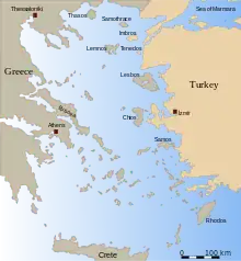
Ios, Io or Nio (Greek: Ίος, Greek pronunciation: [iːos], Ancient Greek: Ἴος; locally Nios Greek: Νιός) is a Greek island in the Cyclades group in the Aegean Sea. Ios is a hilly island with cliffs down to the sea on most sides, situated halfway between Naxos and Santorini. It is about 18 kilometres (11 miles) long and 10 kilometres (6 miles) wide, with an area of 109.024 square kilometres (42.094 sq mi).[5] Population was 2,024 in 2011 (down from 3,500 in the 19th century). Ios is part of the Thira regional unit.[6]
Ios
Ίος Nios | |
|---|---|
Island and Municipality | |
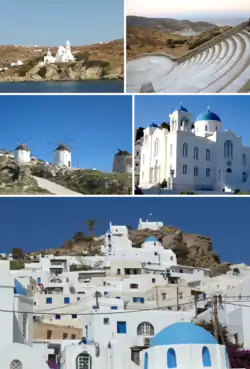 Clockwise from top: Church of Saint Irene, Odysseas Elytis Theatre, Cathedral Church Of Ios, Chora Hill, Windmills in Chora | |
 Flag  Seal Logo[1] | |
| Nickname(s): Μικρή Μάλτα (Little Malta)[2] | |
 | |
| Coordinates: 36°43′0″N 25°20′11″E | |
| Country | Greece |
| Administrative region | South Aegean |
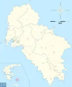
| Regional unit | Thira |
| Municipality founded | 10 March 1835 |
| Capital | Chora |
| Government | |
| • Mayor | Gkikas Gkikas (Independent) |
| Area | |
| • Total | 109.024 km2 (42.094 sq mi) |
| Highest elevation (Kastro Peak) | 713 m (2,339 ft) |
| Lowest elevation | 0 m (0 ft) |
| Population (2011) | |
| • Total | 2,024 |
| • Density | 19/km2 (48/sq mi) |
| Demonym(s) | Ιήτης (Iitis)[3] (official) Ιέτης (Ietis)[4] (Ancient Alternative) Νιώτης (Niotis) (local) Iitian or Ietian(anglicised) |
| Time zone | UTC+2 (EET) |
| • Summer (DST) | UTC+3 (EEST) |
| Postal code | 840 01 |
| Telephone | 22860 |
| Website | ios |
Chora
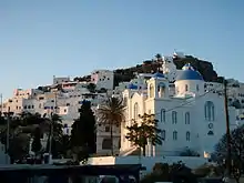
The Port of Ios is at the head of the Ormos harbour in the northwest. There is a path up the nearby hill to Chora, the Greek word on every island for the main village. Chora is a white and cycladic village, full of stairs and narrow paths that make it inaccessible for cars of any kind. Today, the main path through this village is completely taken over by tourism in terms of restaurants, boutiques, bars and discothèques. Apart from the port and the village of Chora, Ios has a few small settlements, just a group of spread out houses in the background of major beaches (Theodoti, Kalamos, Manganari). Since the 1990s, the island mayor Pousseos has worked on Ios' development towards attracting different types of tourists. With the help of European Community funds some roads have been built, all of them paved, and a scenic amphitheatre was created by the German architect Peter Haupt at the top of the village hill.
Name
According to Plutarch it is thought that the name has derived from the Ancient Greek word for violets "Ία"(Ia) because they were commonly found on the island[7] and it is the most accepted etymology. Others say that the name is derived from Phoenician word iion, meaning “pile of stones” but Pliny the Elder writes that the name comes from the Ionians which lived in the island.[8] In the Ottoman period the island was called Anza or Aina, and its present name was officially established in the 19th century after over 2000 years of usage. During the ancient times the island was also called "Φοινίκη" (Phiniki), named after and by the Phoenicians and in the 3rd century, when the island joined League of the Islanders was probably temporarily named Arsinoe after the wife of Ptolemy II[9][7] Today the inhabitants of the Cycladic Islands call the island Nio, a name deriving from the Byzantine Era.[10] The name Little Malta, which is found in texts of travelers during the Ottoman domination, is related to the permanent presence of pirates on the island.[2] In languages with Latin script, the island name is Nio or Io.
Geography and geology
The shape of Ios resembles a rectangle, with an average side size of 15 km (9.3 mi) and 7 km (4.3 mi) respectively. The longest axis is in the NW direction, from the Karatza cape to the Achlades Peninsula and is 17.5 km (10.9 mi) long, while the longest axis, in the AD direction, is 14 km (8.6 mi) long. Ios has 86 km (53.4 mi) of coastline, of which 32 km (19.9 mi) re sandy beaches.[11]
The highest elevation (723 m, 2372 ft) is the Kastro (Greek: Κάστρο) peak also called Pyrgos (Greek: Πύργος), located in the center of the island, while around the Kastro are the next three Highest peaks: Xylodema (Greek: Ξυλόδεμα) (660 m, 2165 ft), Kostiza (Greek: Κοστίζα) (586 m, 1923 ft) and Prophetis Elias (Greek: Προφήτης Ηλίας) (490 m, 951 ft).[11]
Ios consists almost entirely of metamorphic rocks, on which lie limited quaternary appearances.[11]
Plan Homer
In case of extreme events like earthquakes, wildfires etc. the Municipality of Ios had prepared a general plan called Homer (Greek: Όμηρος) which includes the cooperation of all Iitians.[12]
Demographics
| Year | Pop. | ±% p.a. |
|---|---|---|
| 1696 | 3,000 | — |
| 1771 | 1,400 | −1.01% |
| 1829 | 2,177 | +0.76% |
| 1856 | 2,167 | −0.02% |
| 1879 | 2,113 | −0.11% |
| 1889 | 2,043 | −0.34% |
| 1896 | 2,171 | +0.87% |
| 1907 | 2,090 | −0.35% |
| 1920 | 2,154 | +0.23% |
| 1928 | 1,797 | −2.24% |
| 1940 | 2,041 | +1.07% |
| 1951 | 1,753 | −1.37% |
| 1961 | 1,343 | −2.63% |
| 1971 | 1,270 | −0.56% |
| 1981 | 1,362 | +0.70% |
| 1991 | 1,654 | +1.96% |
| 2001 | 1,838 | +1.06% |
| 2011 | 2,024 | +0.97% |
| Source: [13][14][15][16][17][18][19][20] [23][24] | ||
According to the Greek census 2011 in Ios live 2084 people, 1754 of them live in Chora. From the 1940s to the early 1970s, there was a constant reduction to the population of the island. The main causes of this phenomenon are the migration movement, the epidemiological conditions of the time and to a lesser extent, the loss of men aged between 18 and 45 during the war.[11]
Food
The island is famous for its local cheeses. They are mainly made in the municipal creamery using milk from goats or sheep. The most famous one is the "skotíri" (σκοτύρι), a sour cheese with the smell of summer savory. Popular dishes of Ios are the "tsimediá" (τσιμεντιά , pumpkin flowers stuffed with rice) and "mermitzéli" (μερμιτζέλι, handmade barley).[25]
Education
In 1827 the local leaders of Ios wrote a letter to the revolutionary government of Greece requesting a school to open in the island.[26] During the 1850s the first school opened which housed a small number of students of all ages. The type of school that operated was called Skolarcheion (Greek: Σχολαρχείον) and was equivalent to an elementary school with some high school basic courses. Most students at the time didn't graduate as they helped their families in the fields and had to give up school. This resulted in a large percentage of illiterate children. The richer families sent their children to schools of the nearby islands. From 1936 the first elementary school was founded. In 1972 the first kindergarten opens and in 1980 the first high school that had some upper highschool courses. Today, in Chora operate a kindergarten, a highschool,a upper highschool and an EPAL highschool.[27]
History
Prehistory
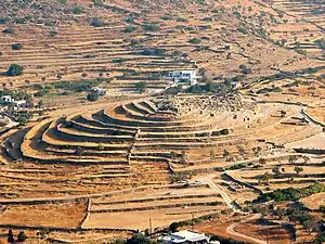
Ios from the prehistoric era and thanks to its safe natural harbour played an important role on the sea roads to Crete. The early Cycladic settlement on Skarkos hill, as well as the many prehistoric sites on the island, tell us a lot about this period.[30]
Ios was under the influence of the Minoan and then of the Mycenaean civilisation. The Phoenicians seem to have arrived on the island and maintained their presence until the 9th century BC. Ios became Ionian at some point after, as testified by its membership in the Ionic Amphictyony. From 534 BC the island paid a tax to Athens.[30]
Classical and Hellenistic times
Ios was an important and strong city in Classical and Hellenistic times. Its decline began with the Roman occupation, when it was used as a place for exile, and continued in Byzantine times. The island experienced a recovery at the time of the Duchy of Naxos, but the Ottoman domination interrupted it. Palaiokastro, a ruined Venetian castle from the 15th century lies on the northern part of the island.[30] Ios was important enough in the Roman province of Insulae to become a suffragan see of the Metropolis of Rhodes, but later faded and disappeared.
Numismatics
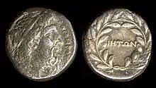
During the 3rd and 2nd century BC as Ios became part of the league of the islanders, she minted her own coins, most of them can be found in the Berlin Archaeological Museum and British Museum. There are 28 known different coins. They depict Homer, a palm tree or Athena, as she was worshiped on the island. Most of them had the writing ΙΗΤΩΝ meaning of the people of Ios.[31]
1820s
Although Ios did not have a strong naval force, it was one of the first islands to raise the flag of revolution in when the Greek War of Independence began in 1821. Ios took part in the naval battle at Kusadasi on July 9, 1821, as well as in the Second National Assembly at Astros in 1823 and in the Third National Assembly at Troezen in 1827.
Modern times
In a new era, the island has begun to emerge since the 70s as it is increasingly becoming a popular tourist destination for young people in Europe. Today Ios retains its reputation as the island of youth and entertainment, but also has excellent tourist infrastructure, organised marina at its harbour and good enough road network. This puts it with the best in the new era.[32]
Ecclesiastically, its territory is now part of the Greek Orthodox Metropolis of Thera, Amorgos and the Islands of the Church of Greece.
Homer's death
The legend
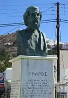
The island is very strongly connected with Homer because according to the legend, Homer died in Ios. The greatest epic poet of the Greeks died because he violated a Pythian oracle. According to Pausanias, Homer visited the Delphi oracle to ask Pythia about his parents and origins. Pythia replied with the oracle "Your mother's home is the island of Ios, which will accept you when you die, but you should be careful of the enigma of the young children.". The poet, however, broke the oracle and traveled to Ios. There he saw some small children fishing on the coast. He asked what they got and the children replied: "Whatever we get we leave it and whatever we don't get we take it with us". The children were talking about lice. Those who found them, killed them, but those who did not find them, had them to their heads. Homer did not find the answer, but he remembered the warning of Pythia. He was horrified and ran away quickly.[33] The road was muddy and the poet in his hurry slipped and fell, hitting his head and dying almost instantaneously.[34]
According to another version, Homer died from his sadness that he did not solve the puzzle, while a third version says he was already seriously ill and went to Ios because he knew he would die. Of course, the death of the great poet is not based on historical studies, but on myths and traditions that circulated from mouth to mouth. Pausanias simply recorded a popular narrative.[33][35]
Graf Pasch van Krienen expedition
In 1771, a Dutch count named Pasch di Krienen after having read the narrative, he came to Ios in order to discover the grave. He was informed by a local priest of the saint Aikaterini chapel that there is a place with marbles and some of which had inscriptions. He decided that they were made a lot after Homer's death but he insisted and with the help of Spyridon Valettas he found three graves and the last one had inscriptions about Homer including Ενθάδε την ιερήν κεφαλήν κατά γαία καλύπτει ανδρών ηρώων κοσμήτορα θείον Όμηρον which means here under the earth lies the sacred head of heroic Homer. When he found this, Pasch was sure that the grave belonged to the epic poet but he realised some grammatical mistakes on the gravestone and he began doubting its authenticity. After having spent a lot of money and time, he decided to give up after having also found two graves at Agia Theodoti[36][37]
Beaches
Ios attracts a large number of young tourists, many of whom used to sleep on their sleeping bags during the 1970s on the popular beach of Mylopotas after partying through the night. Today Mylopotas beach has been developed to an equivalent mass package tourism resort like Platys Gialos and Paradise Beach of Mykonos.
Climate
Ios has a warm-summer Mediterranean climate with mild winters and pleasant summers. Similar to other Cyclades islands, there is an almost constant breeze from the north during summer, known as meltemi, which moderates temperatures.
| Climate data for Ios island (3m) | |||||||||||||
|---|---|---|---|---|---|---|---|---|---|---|---|---|---|
| Month | Jan | Feb | Mar | Apr | May | Jun | Jul | Aug | Sep | Oct | Nov | Dec | Year |
| Average high °C (°F) | 14.7 (58.5) |
15.5 (59.9) |
17.3 (63.1) |
18.9 (66.0) |
23.8 (74.8) |
27 (81) |
29.2 (84.6) |
29.3 (84.7) |
26.8 (80.2) |
24.6 (76.3) |
20.6 (69.1) |
17.6 (63.7) |
22.1 (71.8) |
| Average low °C (°F) | 10.1 (50.2) |
11 (52) |
12.5 (54.5) |
14 (57) |
17.4 (63.3) |
21.9 (71.4) |
23.9 (75.0) |
24.5 (76.1) |
22.4 (72.3) |
19.7 (67.5) |
16.5 (61.7) |
13.6 (56.5) |
17.3 (63.1) |
| Average precipitation mm (inches) | 74 (2.9) |
69.8 (2.75) |
66.2 (2.61) |
25.2 (0.99) |
1 (0.0) |
0.5 (0.02) |
0.1 (0.00) |
0 (0) |
1.6 (0.06) |
33.7 (1.33) |
53.5 (2.11) |
52.6 (2.07) |
378.2 (14.84) |
| Source: http://penteli.meteo.gr/stations/ios/ (2019 – 2020 averages) | |||||||||||||
Timeline
| Year | Event |
|---|---|
| 3rd millennium BC | Humans start living in the island |
| 350 BC | The island minted the first coins depicting Homer |
| 314 BC | The island joined the League of the Islanders |
| 300 BC - 200 | It becomes part of the Roman Empire and part of the provincia insularum |
| 286 | It becomes part of the Byzantine Empire |
| 1207 | The island is conquered by the Franks and becomes a part of the Duchy of Naxos |
| 1269 | The island is regained by the Byzantine Empire |
| 1296 | The island is conquered by Domenico Schiavi and remained in his family |
| 1335 | The island is conquered for a second time by the Duchy of Naxos |
| 1371 | The island is under Francesco I Crispo's control and his family's |
| 1537 | The island is occupied by Hayreddin Barbarossa but remains under the control of the Crispo family |
| 1558 | The island is attacked by Pirates causing most of the people of Ios to move to other islands |
| 1566 | After the death of the last Cripi, the island becomes part of the Ottoman Empire and its under the administration of Joseph Nasi |
| March 1, 1821 | Panagiotis Amoiradakis raised the flag of the Greek revolution in Ios |
| July 9, 1821 | The island takes part in the Naval battle of Kuşadası |
| 1830 | Ios becomes part of Greece |
Notable people
Modern
- Spyridon Valetas (1779–1843), scholar, member of Filiki Eteria
- Lakis Nikolaou (1949– ), footballer
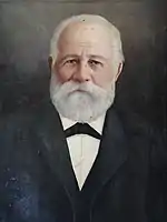
- Jean-Marie Drot (1929-2015), writer and cinematographer who loved the island and also founded The Jean Marie Drot Museum in Ios[38]
Gallery
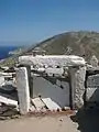 Tomb of Homer
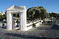 View of Chora
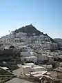 Chora
Chora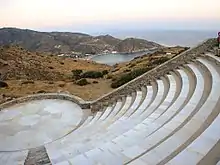
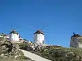 Windmills
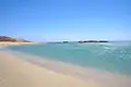 Manganari Beach
 Young Hippies on Ios during the 1970s
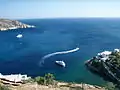 Western view of Ios
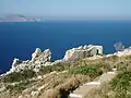 Eastern view of Ios
References
- "Archived copy" (PDF). Archived (PDF) from the original on 2018-03-25. Retrieved 2018-03-25.CS1 maint: archived copy as title (link)
- "Archived copy". Archived from the original on 2018-03-19. Retrieved 2018-03-18.CS1 maint: archived copy as title (link)
- http://www.perseus.tufts.edu/hopper/text?doc=Perseus:text:1999.04.0064:entry=ios-geo&highlight=ios%2Ccoin
- http://www.poesialatina.it/_ns/greek/testi/Stephanus/Ethnica.html
- "Population & housing census 2001 (incl. area and average elevation)" (PDF) (in Greek). National Statistical Service of Greece. Archived from the original (PDF) on 2015-09-21.
- Kallikratis law Archived 2011-05-15 at the Wayback Machine Greece Ministry of Interior (in Greek)
- Newsroom (19 October 2015). "Ίος: Το νησί του Ομήρου". Archived from the original on 11 December 2017.
- "Untitled Document". gym-iou.kyk.sch.gr. Archived from the original on 2017-12-28. Retrieved 2017-12-17.
- http://www2.egeonet.gr/Forms/fLemmaBodyExtended.aspx?lemmaID=10418
- "Archived copy". Archived from the original on 2017-03-18. Retrieved 2018-03-17.CS1 maint: archived copy as title (link)
- http://tya.ios.gr/wp-content/uploads/2017/09/file-18.pdf
- https://diavgeia.gov.gr/doc/68%CE%97%CE%97%CE%A9%CE%95%CE%A0-%CE%A3%CE%A7%CE%9C?inline=true
- http://dlib.statistics.gr/Book/GRESYE_02_0101_00025.pdf p.36
- http://tya.ios.gr/wp-content/uploads/2017/09/file-18.pdf p.34
- http://dlib.statistics.gr/Book/GRESYE_02_0101_00023.pdf p.211
- http://dlib.statistics.gr/Book/GRESYE_02_0101_00016.pdf p.180
- http://dlib.statistics.gr/Book/GRESYE_02_0101_00004.pdf p.97
- http://dlib.statistics.gr/Book/GRESYE_02_0101_00003.pdf p.17
- http://dlib.statistics.gr/Book/GRESYE_02_0101_00002.pdf p.14
- http://dlib.statistics.gr/Book/GRESYE_02_0101_00097.pdf p.37
- Βικέντιος Κορονέλι Isolario volume II page 262, Venice 1696
- Πας Βαν Κρινεν Brave discrizione dell Archipelago, Livorno 1773
- http://nefeli.lib.teicrete.gr/browse/sdo/tour/2011/DrakouMargarita/attached-document-1300432232-113994-30049/drakou2011.pdf
- Kapodistrias 1829 census
- http://www.athinorama.gr/travel/greece/guide.aspx?artid=1168&did=361&aid=710060 Archived 2018-01-04 at the Wayback Machine
- Η εκπαίδευση κατά την Ελληνική Επανάσταση page 182 ISBN 9789605600518
- http://nefeli.lib.teicrete.gr/browse/sdo/tour/2011/DrakouMargarita/attached-document-1300432232-113994-30049/drakou2011.pdf page 66-67
- Εκπαίδευση, Η νήσος Ίος book by Othonaios Theodoros, Athens 1936
- http://pandektis.ekt.gr/pandektis/handle/10442/131718
- "Ίος Ιστορία". www.iosinfo.gr. Archived from the original on 2017-03-01.
- E Nesos Ios(Ios Island) by Theodoros Othonaios, Athens 1936 page 78
- "Archived copy". Archived from the original on 2017-03-01. Retrieved 2017-12-18.CS1 maint: archived copy as title (link)
- "Πώς πέθανε ο ποιητής Όμηρος που αψήφησε το χρησμό του μαντείου; Ο θρύλος με το αίνιγμα που δεν κατάφερε να λύσει και τον οδήγησε στο θάνατο - ΜΗΧΑΝΗ ΤΟΥ ΧΡΟΝΟΥ". 16 April 2015. Archived from the original on 28 December 2017.
- Herodotus (1761). "Hē tou Hērodotou Halikarnasseōs historia (Romanized form)".
- "Archived copy" (PDF). Archived (PDF) from the original on 2018-03-10. Retrieved 2018-03-10.CS1 maint: archived copy as title (link)
- GŎmýrou bíos@ kaì poiýmata page 45
- Breve Descrizione del Arcipelago by Pasch di Krienen, 1771, page 35-47
- https://yallou.com/greece/1452/Ios-Island/Ios-Town/Sightseeing/Museum-of-Modern-Art-Jean-Marie-Drot/
External links
 Ios travel guide from Wikivoyage
- Municipality of Ios (in Greek and English)
| Regional unit of Andros | 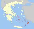 | |
|---|---|---|
| Regional unit of Kalymnos | ||
| Regional unit of Karpathos | ||
| Regional unit of Kea-Kythnos | ||
| Regional unit of Kos | ||
| Regional unit of Milos | ||
| Regional unit of Mykonos | ||
| Regional unit of Naxos | ||
| Regional unit of Paros | ||
| Regional unit of Rhodes | ||
| Regional unit of Syros | ||
| Regional unit of Thira | ||
| Regional unit of Tinos | ||
| Authority control |
|---|
