Itapoá
Itapoá is a municipality in the northern part of the state of Santa Catarina, Brazil. It borders the municipal areas of São Francisco do Sul in the south and of Garuva in the east. In the north it borders with the state of Paraná. It is the northernmost municipality in Santa Catarina.
Itapoá | |
|---|---|
| Itapoá Municipality | |
 Flag  Seal | |
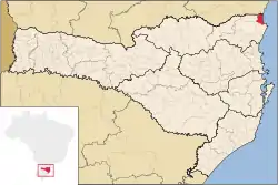 Location of Itapoá | |
| Coordinates: 26°07′01″S 48°36′57″W | |
| Country | |
| Region | South |
| State | Santa Catarina |
| Founded | April 26, 1989 |
| Government | |
| • Mayor | Sergio Ferreira de Aguiar (PMDB) |
| Area | |
| • Total | 257.158 km2 (99.289 sq mi) |
| Elevation | 18 m (59 ft) |
| Population (2020 [1]) | |
| • Total | 21,177 |
| • Density | 48.3/km2 (125/sq mi) |
| Time zone | UTC-3 (UTC-3) |
| • Summer (DST) | UTC-2 (UTC-2) |
| HDI (2000) | 0.793 – medium[2] |
Itapoá was originally part of the municipality of Garuva, but gained independency in 1989.
Its main revenue originates from tourism, due to its situation at the Atlantic coast. The nature reserve "Volta Velha" in the premises of the municipality is one of the last large-scale remnant of Restinga vegetation in the state.
References
- IBGE 2020
- Archived 2009-10-03 at the Wayback Machine - UNDP
| |
| Canoinhas | |
| Joinville | |
| São Bento do Sul | |
This article is issued from Wikipedia. The text is licensed under Creative Commons - Attribution - Sharealike. Additional terms may apply for the media files.