Ivory Island
Ivory Island Lightstation is located 14 miles northwest of Bella Bella[1] on the junction of Seaforth Channel and Milbanke Sound[2] on the Inside Passage of British Columbia.
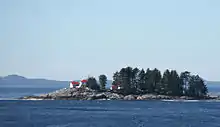
Ivory Island Lightstation
Climate
Ivory Island has a wet and mild Oceanic climate. (Cfb)
| Climate data for Ivory Island (1981–2010) | |||||||||||||
|---|---|---|---|---|---|---|---|---|---|---|---|---|---|
| Month | Jan | Feb | Mar | Apr | May | Jun | Jul | Aug | Sep | Oct | Nov | Dec | Year |
| Record high °C (°F) | 16.5 (61.7) |
15.5 (59.9) |
19.0 (66.2) |
25.5 (77.9) |
24.5 (76.1) |
33.0 (91.4) |
32.2 (90.0) |
29.0 (84.2) |
29.0 (84.2) |
22.0 (71.6) |
14.4 (57.9) |
15.5 (59.9) |
33.0 (91.4) |
| Average high °C (°F) | 6.2 (43.2) |
7.0 (44.6) |
8.0 (46.4) |
10.5 (50.9) |
12.5 (54.5) |
14.5 (58.1) |
16.2 (61.2) |
16.9 (62.4) |
15.3 (59.5) |
11.7 (53.1) |
8.3 (46.9) |
6.7 (44.1) |
11.1 (52.0) |
| Daily mean °C (°F) | 4.3 (39.7) |
4.9 (40.8) |
5.8 (42.4) |
8.0 (46.4) |
10.3 (50.5) |
12.6 (54.7) |
14.3 (57.7) |
14.9 (58.8) |
13.2 (55.8) |
9.8 (49.6) |
6.5 (43.7) |
4.9 (40.8) |
9.1 (48.4) |
| Average low °C (°F) | 2.5 (36.5) |
2.8 (37.0) |
3.4 (38.1) |
5.5 (41.9) |
8.1 (46.6) |
10.6 (51.1) |
12.4 (54.3) |
12.9 (55.2) |
11.0 (51.8) |
7.8 (46.0) |
4.6 (40.3) |
3.1 (37.6) |
7.0 (44.6) |
| Record low °C (°F) | −15.0 (5.0) |
−10.5 (13.1) |
−13.9 (7.0) |
−1.7 (28.9) |
0.0 (32.0) |
4.9 (40.8) |
6.1 (43.0) |
5.0 (41.0) |
2.2 (36.0) |
−1.0 (30.2) |
−12.0 (10.4) |
−12.5 (9.5) |
−15.0 (5.0) |
| Average precipitation mm (inches) | 297.6 (11.72) |
194.5 (7.66) |
229.5 (9.04) |
211.3 (8.32) |
147.0 (5.79) |
129.1 (5.08) |
118.1 (4.65) |
163.7 (6.44) |
215.2 (8.47) |
353.3 (13.91) |
383.7 (15.11) |
326.3 (12.85) |
2,769.2 (109.02) |
| Source: Environment Canada[3] | |||||||||||||
References
- "Archived copy". Archived from the original on 2011-07-19. Retrieved 2011-03-19.CS1 maint: archived copy as title (link)
- http://www.lighthousedepot.com/lite_explorer.asp?action=display_details&LighthouseID=1334
- Environment Canada—. Retrieved September 5 2017.
This article is issued from Wikipedia. The text is licensed under Creative Commons - Attribution - Sharealike. Additional terms may apply for the media files.