Jabal Arkanu
Mount Arkanu or Jabal Arkanu (also Jebel Arkenu or Gebel Árchenu) is a mountain in Libya.
| Mount Arkanu | |
|---|---|
| جبل أركنو Jabal Arkanu | |
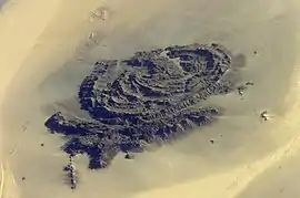 Mount Arkanu seen from space | |
| Highest point | |
| Elevation | 1,435 m (4,708 ft) |
| Coordinates | 22°12′30″N 24°44′15″E |
| Dimensions | |
| Length | 28 km (17 mi) ENE/WSW |
| Width | 18 km (11 mi) NNW/SSE |
| Geography | |
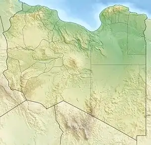 Location in Libya | |
| Country | Libya |
Geography
The mountain is located in the Libyan Desert in the Kufra District of Libya, about 300 km southeast of El Tag.[1] and about 70 km west of Arkanu and the two Arkenu structures. Its height is 1,435 metres (4,708 ft), rising about 500 m above the surrounding Gilf Kebir plateau and a valley-oasis. Mount Arkanu is 28 kilometres (17 mi) long and 18 kilometres (11 mi) wide.[2]
Arkanu's existence has been known since 1892 through Arab sources. Arkanu was first discovered in 1923 by Ahmed Hassanein.[1] The mountain consists of intrusive granite. The valley is 15 km long and oriented east-west.[1] The valley has a green environment consisting of bushes, grass and some trees.[1]
Arkanu is used as a pasture. Each year the Bedouins bring their herds to the valley, leave them there and block the entrance (located at a height of 598 metres (1,962 ft)) with rocks. They return three months later to retrieve their cattle.[1]
Sources
- Bertarelli, L.V. (1929). Guida d'Italia, Vol. XVII (in Italian). Milano: Consociazione Turistica Italiana.
Notes
- Bertarelli (1929), p. 515
- Google Earth