Jablonné v Podještědí
Jablonné v Podještědí, previously Německé Jablonné (German: Deutsch Gabel, until 1901 Gabel) is a town in Liberec District in the Liberec Region of the Czech Republic.
Jablonné v Podještědí | |
|---|---|
Town | |
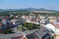 View over Peace Square towards Lusatian Mountains | |
 Flag  Coat of arms | |
 Jablonné v Podještědí Location in the Czech Republic | |
| Coordinates: 50°45′56″N 14°45′39″E | |
| Country | |
| Region | Liberec |
| District | Liberec |
| First mentioned | 1241 |
| Government | |
| • Mayor | Jiří Rýdl |
| Area | |
| • Total | 57.85 km2 (22.34 sq mi) |
| Elevation | 315 m (1,033 ft) |
| Population (2020-01-01[1]) | |
| • Total | 3,667 |
| • Density | 63/km2 (160/sq mi) |
| Time zone | UTC+1 (CET) |
| • Summer (DST) | UTC+2 (CEST) |
| Postal code | 471 25 |
| Website | www.jablonnevp.cz |
History
Until 1918, the town was part of the Austrian monarchy (Austria side after the compromise of 1867), head of the Gabel district (later Gabel bei Niemes), one of the 94 Bezirkshauptmannschaften in Bohemia.[2] In 1918, it became a part of independent Czechoslovakia.
In 1938, Jablonné was ceded to Nazi Germany as a result of the Munich Agreement. Until 1945, it was administered as a part of the Regierungsbezirk Aussig of Reichsgau Sudetenland. In May 1945, after the liberation of Czechoslovakia, it returned under Czechoslovak administration.
Notable people
- Karl von Ergert (1795–1865), Austrian military officer
- Franz Ergert (1858–1931), Austrian industrialist
- Wenzel Bürger (1869–1946), German architect
- Alfred Gürtler (1875–1933), Austrian economist and politician
Gallery
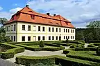 Palme manor
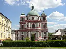 Saint Lawrence Basilica
%252C_kapel_Dm256595-4530_IMG_7332_2018-08-09_15.41.jpg.webp) Chapel in Petrovice
Chapel in Petrovice
References
- "Population of Municipalities – 1 January 2020". Czech Statistical Office. 2020-04-30.
- Die postalischen Abstempelungen auf den österreichischen Postwertzeichen-Ausgaben 1867, 1883 und 1890, Wilhelm KLEIN, 1967
External links
| Wikimedia Commons has media related to Jablonné v Podještědí. |
- (in Czech) Official website
| Authority control |
|
|---|
This article is issued from Wikipedia. The text is licensed under Creative Commons - Attribution - Sharealike. Additional terms may apply for the media files.