Jacobs Well, Queensland
Jacobs Well is a coastal suburb of the City of Gold Coast, Queensland, Australia.[2] The suburb is positioned on the delta of the Pimpama River at the southern end of Moreton Bay. At the 2016 census, the suburb recorded a population of 1,839.[1]
Jacobs Well is best known for its four lane boat ramp, Volunteer Marine Rescue facility and the surrounding sugar cane fields. It is often described as "The Gateway to Southern Moreton Bay"
| Jacobs Well Gold Coast, Queensland | |||||||||||||||
|---|---|---|---|---|---|---|---|---|---|---|---|---|---|---|---|
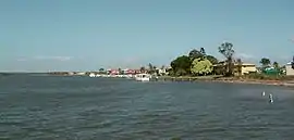 Tipplers Passage, 2014 | |||||||||||||||
| Population | 1,839 (2016 census)[1] | ||||||||||||||
| • Density | 135.52/km2 (350.99/sq mi) | ||||||||||||||
| Postcode(s) | 4208 | ||||||||||||||
| Area | 13.57 km2 (5.2 sq mi) | ||||||||||||||
| LGA(s) | City of Gold Coast | ||||||||||||||
| State electorate(s) | Coomera | ||||||||||||||
| Federal Division(s) | Fadden | ||||||||||||||
| |||||||||||||||
Jacobs Well was once part of the Shire of Albert. It belongs to the Electoral district of Coomera state electorate.
Geography
Jacobs Well is bounded to the north by Steiglitz, to the east by Moreton Bay, to the south by the Pimpama River and to the west by Norwell.
History
In the late 1800s, the farming district located between the Pimpama River and the Logan River called Pimpama Island encompassed the modern localities of Jacobs Well, Norwell, Steiglitz and Woongoolba. It was referred to as an island because there were a number of lagoons and swamps that isolated the area during the wet season; however, this disadvantage made it good land for growing sugar cane.[3]
Amenities
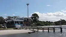
Jacobs Well offers many amenities for the boating and fishing enthusiast. It has a sandy beach facing Moreton Bay, with an enclosed swimming area, barbeque facilities and a well stocked fishing tackle & bait shop; a four-lane boat ramp, pontoon, parking for cars with trailers, and camping ground.[4] A volunteer marine rescue service operates from Jacobs Well, providing services on Moreton Bay, the Gold Coast Broadwater and in the Coomera, Logan and Albert Rivers.[5] The village boasts a doctors surgery, chemist, small supermarket, bakery, real estate agents, hair dressers, several cafes, takeaways & a tavern with a quality restaurant.
The Gold Coast City Council operates a fortnightly mobile library service which visits the Community Centre on Bay Drive.[6]
Calypso Bay
Calypso Bay is a canal estate at the south end of Jacobs Well. Established via the use of a converted sand mining lease, the surrounding mangrove tidal land was turned into a canal estate by using sand from the creation of the canals. The area remains surrounded by a largely pristine natural environment, providing a habitat for native birds and wildlife and continues to be an important marine sanctuary. Calypso Bay offers a range of waterfront homesites with direct boating access to The Broadwater and Moreton Bay. The GFC slowed the development of the site, with stages of land release ongoing. A promised golf course is still in the planning stage. The marina is operational, though not developed to its final stage yet.
References
- Australian Bureau of Statistics (27 June 2017). "Jacobs Well (State Suburb)". 2016 Census QuickStats. Retrieved 29 March 2018.

- "Jacobs Well (entry 46055)". Queensland Place Names. Queensland Government. Retrieved 19 February 2014.
- "Woongoolba History". City of Gold Coast Council. Retrieved 5 April 2014.
- "Boating facilities in Queensland — Brisbane" (PDF). Marine Safety Queensland. 2009. Archived from the original (PDF) on 12 March 2014. Retrieved 14 April 2014.
- "About us". Volunteer Marine Rescue Jacobs Well. VMR Jacobs Well Assn Inc. Retrieved 14 April 2014.
- "Mobile Library 2018 timetable" (PDF). Gold Coast City Council. Archived from the original (PDF) on 30 January 2018. Retrieved 30 January 2018.
External links
| Wikimedia Commons has media related to Jacobs Well, Queensland. |
- "Jacobs Well". Queensland Places. Centre for the Government of Queensland, University of Queensland.
- "Jacobs Well Progress Association".