Jamma River
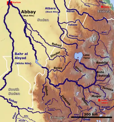
The Jamma River is a river in central Ethiopia and a tributary of the Abay (or Blue Nile) on its right side. It drains parts of the Semien Shewa Zones of the Amhara and Oromia Regions. The Upper Jamma flows through steep, deep canyons cut first through volcanic rock and then through the Cretaceous sandstone and shaly sandstone, with Jurassic limestone at the bottom.[1] It has a drainage area of about 15,782 square kilometers in size.[2] Tributaries include the Wanchet.
| Jamma River | |
|---|---|
 Map showing the Abbay basin, with the Jamma River (Bottom right) | |
| Location | |
| Country | Ethiopia |
| Physical characteristics | |
| Mouth | |
• location | Blue Nile |
• coordinates | 10.1572°N 38.3412°E |
The earliest mention of this river is in the Gadla of Tekle Haymanot, which was written in the fourteenth century.[3] One of the earliest European mentions is by the missionary Pedro Páez, who was the first European to see and describe the origin of the Abay.[1] According to Johann Ludwig Krapf, in the 1840s the Jamma defined the boundary between Marra Biete and Moret, two districts of the former province or Sultanate of Shewa.[4]
Notes
- "Local History in Ethiopia" Archived 2011-05-28 at the Wayback Machine (pdf) The Nordic Africa Institute website (accessed 29 January 2008)
- "Tana & Beles Integrated Water Resources Development: Project Appraisal Document (PAD), Vol.1", World Bank, 2 May 2008 (accessed 5 May 2009)
- G.W.B. Huntingford, The historical geography of Ethiopia from the first century AD to 1704, (Oxford University Press: 1989), p. 69
- Journals of the Rev. Messrs. Isenberg and Krapf, Missionaries of the Church Missionary Society, Detailing their proceedings in the kingdom of Shoa, and journeys in other parts of Abyssinia, in the years 1839, 1840, 1841 and 1842, (London, 1843), p. 290
External links
- Ethiopia Disaster Prevention and Preparedness Agency: Administrative atlas: Oromiya region
- Ethiopia Disaster Prevention and Preparedness Agency: Flood Vulnerable Areas as of August 24, 2006
