Jeita
Jeita (Arabic: جعيتا Jʿītā; also spelled Jaaita or Jaita) is a town and municipality located in the Keserwan District of the Mount Lebanon Governorate of Lebanon. The town is about 20 kilometres (12 mi) north of Beirut.[1] It has an average elevation of 380 meters above sea level and a total land area of 290 hectares.[1] Jeita's inhabitants are Maronites.[2]
Jeita
جعيتا Jaita, Jaaita | |
|---|---|
Municipality | |
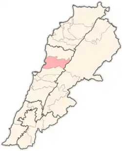
 Jeita Location in Lebanon | |
| Coordinates: 33°57′14″N 35°38′36″E | |
| Country | |
| Governorate | Mount Lebanon |
| District | Keserwan |
| Time zone | UTC+2 (EET) |
| • Summer (DST) | UTC+3 (EEST) |
It is well known for the Jeita Grotto which is a popular tourist attraction, as well as the Nahr al-Kalb, a river that runs from a spring near the grotto emptying into the Mediterranean Sea. The name Jeita is derived from the Aramaic word Ge’itta, meaning "roar" or "noise".[3]
References
- "Jaaita". Localiban. Localiban. 2008-01-21. Retrieved 2009-07-24.
- "Elections municipales et ikhtiariah au Mont-Liban" (PDF). Localiban. Localiban. 2010. p. 19. Archived from the original (pdf) on 2015-07-24. Retrieved 2016-02-12.
- Lebanese Maronite Villages or Towns Archived 2009-06-23 at the Wayback Machine. Retrieved on 2009-07-24.
Capital: Jounieh | ||
| Towns and villages |
|  |
| Notable landmarks | ||
This article is issued from Wikipedia. The text is licensed under Creative Commons - Attribution - Sharealike. Additional terms may apply for the media files.
