Jemez Canyon Dam
Jemez Canyon Dam (National ID # NM00003) is a dam in Sandoval County, New Mexico, a few miles north of Albuquerque.
| Jemez Canyon Dam | |
|---|---|
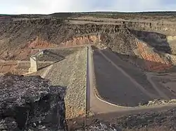 Jemez Dam | |
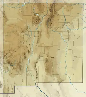 Location of Jemez Canyon Dam in New Mexico | |
| Country | United States |
| Location | Sandoval County, New Mexico |
| Coordinates | 35.39437°N 106.54702°W |
| Purpose | Flood control and storm water management |
| Opening date | 1953 |
| Owner(s) | United States Army Corps of Engineers |
| Dam and spillways | |
| Height | 150 feet (46 m) |
| Length | 870 feet (270 m) |
| Reservoir | |
| Total capacity | 264,700 acre-feet |
| Surface area | 2.2 square miles (5.7 km2) |
The earthen dam was constructed in 1953 by the United States Army Corps of Engineers, with a height of 150 feet and a length at its crest of 870 feet.[1] It impounds the Jemez River for flood control and storm water management in the spring and early summer seasons.[2] The dam is owned by the Corps of Engineers, and operated by the Corps and the Cochiti Lake Project Office.
The reservoir it creates, Jemez Canyon Reservoir, has a normal water surface of 2.2 square miles and a maximum capacity of 264,700 acre-feet. Normal storage is about one tenth that volume.[3] Recreation is limited. There is no access to the water. All land surrounding the reservoir, except a small day-use area with picnic facilities and a scenic overlook, is the property of Santa Ana Pueblo, with restricted access.[4]