Johann Matthias Hase
Johann Matthias (Matyhias) Hase (Haas, Haase) (Latinized as Johannes Hasius) (14 January 1684 – 24 September 1742) was a German mathematician, astronomer, and cartographer.
Biography
Hase taught at Leipzig and his native Augsburg. In 1720, he became professor of mathematics at the University of Wittenberg.
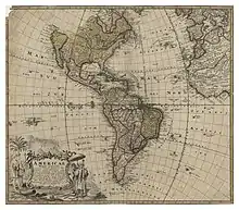
Hase made maps for the publishing firm of Homännische Erben ("Homännis' Heirs"), such as the following:
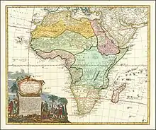
- Africa Secundum legitimas Projectionis Stereographiae regulas (1737) which itself was based on the maps developed by Leo Africanus[1]
- Kingdoms of David and Solomon (1739). In 1739 at Nuremberg, Hase published his Regni Davidici et Salomonaei descriptio geographica et historica, una cum delineatione Syriae et Aegypti pro statu temporum sub Seleucidis et Lagidis regibus mappis luculentis exhibita, et probationibus idoneis instructa. Juncta est huic operi consideratio urbium maximarum veterum et recentiorum, ac operum quorundam apud antiquos celebrium. This work, as a historical survey of the kingdoms of David and Solomon, as well as of the dominions of the Seleucids, included maps of Syria and Egypt
- Europa secundum legitimas projectionis stereographieae regulas (1743).
- Asia secundum legitimas projectionis stereographieae regulas (1744).
.jpg.webp)
- Hungariae ampliori significatu et veteris vel Methodicae complexae Regna (1744). In 1744, he made the political map Hungariae ampliori significatu et veteris vel Methodicae complexae Regna (published at Nuremberg). It shows the Kingdom of Hungary, as well as countries along the Danube and in Southeast Europe.
Hase died in Wittenberg. The crater Hase on the Moon is named after him.
Allegories
Based on what is known of the sources of the Africa map, Hase primary contribution to the maps were adding a cultural explanation in the form of Allegorical cartoons on the map itself, though he may have had a greater role in other maps. On the map of Africa, for example, he added in the lower corner of the map a large allegorical scene showing a finely dressed woman in clothes that are similar to modern-day clothing. The men are either dressed with single piece servants clothes, or an African rulers garbs, or fully dressed European traders. Notably, the indigenous African ruler is sitting on the back of a crouching human prostrating as a stool. Also shown in the allegory are lions and other animals and some semblance of life on the continent. The Asia map also has such allegorical scene.
References
- "1737 - J. B. Homann - Africa Secundum legitimas". Retrieved 2020-06-21.
- "1737 - J. B. Homann - Africa Secundum legitimas". Retrieved 2020-06-21.
- USC Public Archives (in English)
- Maps of Europe (in English)
- Die Mathematikprofessoren der Leucorea (in German)
- Slowakeiportal (in German)
| Authority control |
|
|---|
