Jonaswalde
Jonaswalde is a municipality in the Thuringian district of Altenburger Land. It belongs to the Verwaltungsgemeinschaft of Oberes Sprottental.
Jonaswalde | |
|---|---|
Location of Jonaswalde within Altenburger Land district 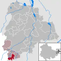 | |
 Jonaswalde  Jonaswalde | |
| Coordinates: 50°50′21″N 12°17′16″E | |
| Country | Germany |
| State | Thuringia |
| District | Altenburger Land |
| Municipal assoc. | Oberes Sprottental |
| Subdivisions | 2 |
| Government | |
| • Mayor | André Vohß |
| Area | |
| • Total | 6.65 km2 (2.57 sq mi) |
| Elevation | 190 m (620 ft) |
| Population (2019-12-31)[1] | |
| • Total | 305 |
| • Density | 46/km2 (120/sq mi) |
| Time zone | UTC+01:00 (CET) |
| • Summer (DST) | UTC+02:00 (CEST) |
| Postal codes | 04626 |
| Dialling codes | 034496 |
| Vehicle registration | ABG |
| Website | www.jonaswalde.de |
Geography
Neighboring municipalities
Nearby municipalities are Heukewalde, Thonhausen, and Vollmershain in the district of Altenburger Land; Rückersdorf in the district of Greiz; as well as the city of Crimmitschau in the Saxon district of Zwickauer Land.
Municipal arrangement
The community is divided into two subdivisions: Jonaswalde and Nischwitz.
History
From 1826 to 1920, Jonaswalde was part of Saxe-Altenburg.
References
- "Bevölkerung der Gemeinden, erfüllenden Gemeinden und Verwaltungsgemeinschaften in Thüringen Gebietsstand: 31.12.2019". Thüringer Landesamt für Statistik (in German). August 2020.
External links
- (in German) a private website from Jonaswalde
- (in German) FOSAVIS, a private website from Dirk Salomon, Jonaswalde
| Authority control |
|
|---|
This article is issued from Wikipedia. The text is licensed under Creative Commons - Attribution - Sharealike. Additional terms may apply for the media files.
