Jud, North Dakota
Jud is a rural hamlet in LaMoure County, North Dakota, United States. The population was 72 at the 2010 census.[5] Jud was founded in 1904 and named for county settler Judson LaMoure.[6] It is located along unpaved 61st Street SE, 9 miles (14 km) west of U.S. Route 281 and 25 miles (40 km) south of Interstate 94 in the midst of settled farmland and open plains.
Jud, North Dakota | |
|---|---|
 Post office in Jud | |
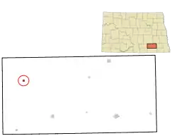 Location of Jud, North Dakota | |
| Coordinates: 46°31′30″N 98°53′53″W | |
| Country | United States |
| State | North Dakota |
| County | LaMoure |
| Area | |
| • Total | 0.24 sq mi (0.63 km2) |
| • Land | 0.24 sq mi (0.63 km2) |
| • Water | 0.00 sq mi (0.00 km2) |
| Elevation | 1,739 ft (530 m) |
| Population | |
| • Total | 72 |
| • Estimate (2019)[3] | 70 |
| • Density | 288.07/sq mi (111.07/km2) |
| Time zone | UTC-6 (Central (CST)) |
| • Summer (DST) | UTC-5 (CDT) |
| ZIP code | 58454 |
| Area code(s) | 701 |
| FIPS code | 38-41180 |
| GNIS feature ID | 1033647[4] |
Geography
Jud is geographically located at 46°31′30″N 98°53′53″W (46.524984, -98.898191).[7]
According to the United States Census Bureau, the city has a total area of 0.25 square miles (0.65 km2), all land.[8]
Demographics
| Historical population | |||
|---|---|---|---|
| Census | Pop. | %± | |
| 1910 | 99 | — | |
| 1920 | 178 | 79.8% | |
| 1930 | 140 | −21.3% | |
| 1940 | 202 | 44.3% | |
| 1950 | 175 | −13.4% | |
| 1960 | 156 | −10.9% | |
| 1970 | 110 | −29.5% | |
| 1980 | 118 | 7.3% | |
| 1990 | 84 | −28.8% | |
| 2000 | 76 | −9.5% | |
| 2010 | 72 | −5.3% | |
| 2019 (est.) | 70 | [3] | −2.8% |
| U.S. Decennial Census[9] 2018 Estimate[10] | |||
2010 census
As of the census[2] of 2010, there were 72 people, 42 households, and 19 families residing in the city. The population density was 288.0 inhabitants per square mile (111.2/km2). There were 50 housing units at an average density of 200.0 per square mile (77.2/km2). The racial makeup of the city was 97.2% White and 2.8% from two or more races.
There were 42 households, of which 11.9% had children under the age of 18 living with them, 40.5% were married couples living together, 2.4% had a female householder with no husband present, 2.4% had a male householder with no wife present, and 54.8% were non-families. 50.0% of all households were made up of individuals, and 23.8% had someone living alone who was 65 years of age or older. The average household size was 1.67 and the average family size was 2.32.
The median age in the city was 54 years. 9.7% of residents were under the age of 18; 4.3% were between the ages of 18 and 24; 16.7% were from 25 to 44; 45.8% were from 45 to 64; and 23.6% were 65 years of age or older. The gender makeup of the city was 50.0% male and 50.0% female.
2000 census
As of the census of 2000, there were 76 people, 43 households, and 20 families residing in the city. The population density was 313.2 people per square mile (122.3/km2). There were 51 housing units at an average density of 210.2 per square mile (82.0/km2). The racial makeup of the city was 98.68% White and 1.32% Asian.
There were 43 households, out of which 14.0% had children under the age of 18 living with them, 39.5% were married couples living together, 7.0% had a female householder with no husband present, and 51.2% were non-families. 48.8% of all households were made up of individuals, and 32.6% had someone living alone who was 65 years of age or older. The average household size was 1.72 and the average family size was 2.29.
In the city, the population was spread out, with 11.8% under the age of 18, 26.3% from 25 to 44, 18.4% from 45 to 64, and 43.4% who were 65 years of age or older. The median age was 54 years. For every 100 females, there were 100.0 males. For every 100 females age 18 and over, there were 103.0 males.
The median income for a household in the city was $22,857, and the median income for a family was $34,375. Males had a median income of $36,250 versus $16,250 for females. The per capita income for the city was $17,095. There were no families and 22.2% of the population living below the poverty line, including no under eighteens and 18.8% of those over 64.
Climate
This climatic region is typified by large seasonal temperature differences, with warm to hot (and often humid) summers and cold (sometimes severely cold) winters. According to the Köppen Climate Classification system, Jud has a humid continental climate, abbreviated "Dfb" on climate maps.[11]
References
- "2019 U.S. Gazetteer Files". United States Census Bureau. Retrieved July 27, 2020.
- "U.S. Census website". United States Census Bureau. Retrieved June 14, 2012.
- "Population and Housing Unit Estimates". United States Census Bureau. May 24, 2020. Retrieved May 27, 2020.
- "US Board on Geographic Names". United States Geological Survey. October 25, 2007. Retrieved January 31, 2008.
- "2010 Census Redistricting Data (Public Law 94-171) Summary File". American FactFinder. United States Census Bureau. Retrieved May 2, 2011.
- Wick, Douglas A. "Jud (Lamoure County)". North Dakota Place Names. Retrieved May 4, 2011.
- "US Gazetteer files: 2010, 2000, and 1990". United States Census Bureau. February 12, 2011. Retrieved April 23, 2011.
- "US Gazetteer files 2010". United States Census Bureau. Archived from the original on July 2, 2012. Retrieved June 14, 2012.
- United States Census Bureau. "Census of Population and Housing". Retrieved January 23, 2014.
- "Population Estimates". United States Census Bureau. Retrieved September 24, 2019.
- Climate Summary for Jud, North Dakota
External links
Municipalities and communities of LaMoure County, North Dakota, United States | ||
|---|---|---|
| Cities | 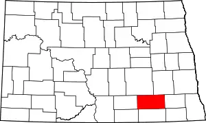 Map of North Dakota highlighting LaMoure County | |
| Townships |
| |
| Unincorporated communities | ||
| ||
| Authority control |
|
|---|