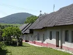
Kálnica
Kálnica (Hungarian: Kalános) is a village and municipality in Nové Mesto nad Váhom District in the Trenčín Region of western Slovakia.
Kálnica | |
|---|---|
Village | |
 | |
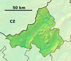 Kálnica Location of Kálnica in the Trenčín Region  Kálnica Kálnica (Slovakia) | |
| Coordinates: 48°46′0″N 17°56′0″E | |
| Country | Slovakia |
| Region | Trenčín |
| District | Nové Mesto nad Váhom |
| First mentioned | 1396 |
| Area | |
| • Total | 26.4 km2 (10.2 sq mi) |
| Elevation | 215 m (705 ft) |
| Population (2004-12-31) | |
| • Total | 1,047 |
| • Density | 40/km2 (100/sq mi) |
| Postal code | 916 37 |
| Area code(s) | +421-32 |
| Car plate | NM |
| Website | www.kalnica.sk |
History
In historical records the village was first mentioned in 1396.
Geography
The municipality lies at an elevation of 215 metres (705 ft) and covers an area of 26.404 km² (10.195 mi²). It has a population of about 1,047.
Genealogical resources
The records for genealogical research are available at the state archive "Statny Archiv in Bratislava, Slovakia"
- Roman Catholic church records (births/marriages/deaths): 1676-1934 (parish B)
Notable residents
- Gyula Kertész (1888–1982), Hungarian footballer
External links
![]() Media related to Kálnica at Wikimedia Commons
Media related to Kálnica at Wikimedia Commons
| Authority control |
|
|---|
This article is issued from Wikipedia. The text is licensed under Creative Commons - Attribution - Sharealike. Additional terms may apply for the media files.
