Käfertal (Mannheim)
Käfertal is a district of Mannheim, Baden-Württemberg, Germany in the Rhine-Neckar metropolitan region which is divided into the districts Käfertal-Mitte, Speckweggebiet, Käfertal-Süd, Sonnenschein and Franklin. It has a population of 27,079 people as of December 31, 2015.[1]
Käfertal | |
|---|---|
Stadtbezirk of Mannheim | |
 Coat of arms | |
Location of Käfertal (Mannheim) 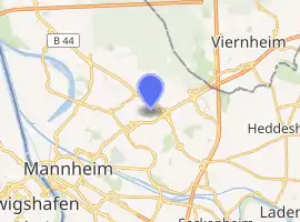
| |
 Käfertal  Käfertal | |
| Coordinates: 49°31′N 8°31′E | |
| Country | Germany |
| State | Baden-Württemberg |
| Admin. region | Karlsruhe |
| District | Urban district |
| City | Mannheim |
| Area | |
| • Total | 10.73 km2 (4.14 sq mi) |
| Population (December 31, 2015) | |
| • Total | 27,079 |
| • Density | 2,500/km2 (6,500/sq mi) |
| Time zone | UTC+01:00 (CET) |
| • Summer (DST) | UTC+02:00 (CEST) |
| Postal codes | 68309 |
| Website | Käfertal-Portal |
Geography
Käfertal is located in the northeast of Mannheim. The neighboring districts are Vogelstang, Feudenheim, Wohlgelegen, and Waldhof. In the northeast is the city of Viernheim (Bergstraße district).
Gallery
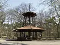 Karlsternpavillon in the Käfertaler Wald
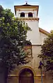 Laurentiuskirche
Literature
- Lorenz Klingert: Festbuch zur Siebenjahrhundert-Feier der ehemaligen Gemeinde Käfertal 1227–1927. Mannheim 1927.
- Günter Bertschmann: Käfertal: 750 Jahre Käfertal 1227–1977. Mannheim 1977.
This article is issued from Wikipedia. The text is licensed under Creative Commons - Attribution - Sharealike. Additional terms may apply for the media files.