Kópasker
Kópasker is a small village with approximately 120 inhabitants[1] in the municipality of Norðurþing, situated on the eastern shore of Öxarfjörður in northeast Iceland.
Kópasker | |
|---|---|
Village | |
.jpg.webp) | |
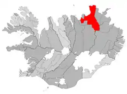 Location of the Municipality of Norðurþing | |
 Kópasker Location in Iceland | |
| Coordinates: 66°18′N 16°27′W | |
| Country | |
| Constituency | Northeast Constituency |
| Region | Northeastern Region |
| Municipality | Norðurþing |
| Population (2011) | |
| • Total | 120 |
| Time zone | UTC+0 (GMT) |
| Post Code | 670, 671 |
.jpg.webp)
Overview
The first residential house in Kópasker, Bakki, was built in 1912 by Árni Ingimundarson. Bakki burned down in 1988.[1] Kópasker grew around the operation of the Co-op, providing services to local agriculture and fisheries. Meat-processing is the biggest industry in Kópasker, represented by the slaughterhouse and lamb-processing factory, Fjallalamb. The District Museum is located at the church site Snartarstaðir by Kópasker. In the village there is also an exhibition at the Kópasker Earthquake Center describing the big earthquake of 1976 that measured 6.3 on the Richter scale and destroyed several houses and other structures in the area.
In Kópasker there is a shop, garage, health care centre, bank, campsite and guesthouses. North of Kópasker is the peninsula Melrakkaslétta, with its abundant birdlife, and also the northernmost point of mainland Iceland, Hraunhafnartangi.
External links
References
- "Kópasker". nordurthing.is. Archived from the original on 3 July 2011. Retrieved 12 June 2011.