Křivoklát
Křivoklát is a market town in the Central Bohemian Region of the Czech Republic. It has about 700 inhabitants.
Křivoklát | |
|---|---|
 | |
 Flag  Coat of arms | |
 Křivoklát Location in the Czech Republic | |
| Coordinates: 50°2′13″N 13°52′43″E | |
| Country | |
| Region | Central Bohemian |
| District | Rakovník |
| First mentioned | 1110 |
| Area | |
| • Total | 6.42 km2 (2.48 sq mi) |
| Elevation | 250 m (820 ft) |
| Population (2020-01-01[1]) | |
| • Total | 673 |
| • Density | 100/km2 (270/sq mi) |
| Time zone | UTC+1 (CET) |
| • Summer (DST) | UTC+2 (CEST) |
| Postal code | 270 23 |
| Website | www |
Tourism
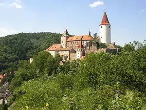
Křivoklát is a popular tourist destination. It is the place where the medieval Křivoklát Castle is located and it also is the seat of the Křivoklátsko Landscape Protected Area.
History
The castle was founded during the 12th century. Between the 14th and 15th centuries, the first cottages appeared below the castle and the hamlet became known as Budy. Nearby hamlet Čamrdoves grew up, and during the 17th and 18th centuries they became one village. In 1886 the hamlets Budy, Amalín, Čamrdoves, and Častonice created one single administrative unit, the village of Křivoklát. A post-office was opened in 1851 under the German name Pürglitz.[2] Until 1918, the village was part of the Austrian monarchy (Austria side after the compromise of 1867), in the Rakonitz – Rakovnik district, one of the 94 Bezirkshauptmannschaften in Bohemia.[3]
References
- "Population of Municipalities – 1 January 2020". Czech Statistical Office. 2020-04-30.
- Handbook of Austria and Lombardy-Venetia Cancellations on the Postage Stamp Issues 1850-1864, by Edwin Mueller, 1961
- Die postalischen Abstempelungen auf den österreichischen Postwertzeichen-Ausgaben 1867, 1883 und 1890, Wilhelm Klein, 1967
External links
 Media related to Křivoklát at Wikimedia Commons
- Official website (in Czech)
- Křivoklát Castle (in English)
- Křivoklátsko Landscape Protected Area
| Authority control |
|---|