K-106 (Kansas highway)
K-106 is a 16.254-mile-long (26.158 km) state highway in the U.S. state of Kansas. K-106 is signed as a west–east route even though the first approximately 6.5 miles (10.5 km) runs directly south to north. K-106's western terminus is at K-18 east of Tescott, and the eastern terminus is at Lake Drive at Ottawa State Fishing Lake. About midway, K-106 serves the city of Minneapolis and intersects U.S. Route 81 (US-81) just west of the city. South of Minneapolis, the highway passes within one mile (1.6 km) of Rock City, a group of 200 spherical boulders designated as a National Natural Landmark.
| |||||||
|---|---|---|---|---|---|---|---|
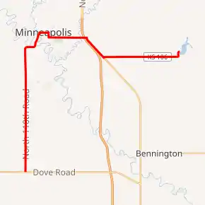
K-106 highlighted in red | |||||||
| Route information | |||||||
| Maintained by KDOT and the city of Minneapolis | |||||||
| Length | 16.254 mi[1] (26.158 km) | ||||||
| Existed | July 8, 1944[2]–present | ||||||
| Major junctions | |||||||
| West end | |||||||
| East end | Lake Drive at Ottawa State Fishing Lake | ||||||
| Location | |||||||
| Counties | Ottawa | ||||||
| Highway system | |||||||
| |||||||

K-106 was first established on July 8, 1944 as a spur from US-81 to Minneapolis. In a May 25, 1949 resolution, a road was extended from the north side of the city to US-81 and became known as K-106N and the original K-106 became K-106S. Then by 1956, K-106S and K-106N became K-106, a complete loop through the city. On July 11, 1956, K-106 was extended southward from Minneapolis to K-18, and the loop within Minneapolis was eliminated. K-106 was extended east on June 14, 1994, over K-93 to Ottawa State Fishing Lake when a new alignment of US-81 was built.
Route description
K-106 begins at an intersection with K-18 and begins travelling north through small rolling hills covered with a mix of farmlands and grasslands. After about one mile (1.6 km) the highway crosses Battle Creek, a tributary of the Solomon River. It continues north to an intersection with Ivy Road, which connects to Rock City, a group of 200 spherical boulders designated as a National Natural Landmark. Here K-106 levels out and transitions to farmlands, as it continues north past an AG by Air airport. As it passes by the airport it crosses Salt Creek then curves east. It continues east for .5 miles (0.80 km) then curves northeast and enters the city of Minneapolis.[3] As it enters the city it crosses the Solomon River then a Union Pacific Railroad track. It then curves east at and begins to follow 1st Street. It then turns south at Rothsay Avenue and leaves 1st Street. It continues south then turns east and begins to follow Laurel Street then passes Highland Cemetery as it exits the city.[4] As it continues east it crosses Lindsey Creek then soon reaches a diamond interchange with US-81. Past US-81 the highway curves southeast and begins to parallel US-81. After just over one mile (1.6 km), K-106 curves east. It continues through flat rural farmlands before intersecting North 180th Road. It continues for one mile (1.6 km) then curves north and ends .3 miles (0.48 km) later at Ottawa State Fishing Lake.[3][5]
The Kansas Department of Transportation (KDOT) tracks the traffic levels on its highways, and in 2018, they determined that on average the traffic varied from 190 vehicles per day at the eastern terminus to 1850 vehicles per day just west of the junction with US-81.[6] K-106 is not included in the National Highway System.[7] The National Highway System is a system of highways important to the nation's defense, economy, and mobility. K-106 does connect to the National Highway System at its junction with US-81.[8] All but 1.522 miles (2 km) of K-106's alignment is maintained by KDOT. The entire section within Minneapolis is maintained by the city.[9]
History
Before state highways were numbered in Kansas there were Auto trails, which were an informal network of marked routes that existed in the United States and Canada in the early part of the 20th century. The former Blue Line follows K-106's southern terminus. The highway crosses the former Sunflower Trail and Meridian Highway in Minneapolis.[10]
| |
|---|---|
| Location | US-81–Ottawa State Fishing Lake |
| Existed | May 1, 1936[11]–June 14, 1994[12] |
K-106 was assigned by the Kansas Department of Transportation (KDOT) on July 8, 1944, when US-81 was moved slightly east to a new alignment. At that time it began at the Minneapolis city limits and ran east along Laurel Street to US-81.[2] In a May 25, 1949 resolution, a road was extended from the north side of the city east along 10th Street to US-81 and became known as K-106N and the original K-106 became K-106S.[13] Between 1953 and 1956, K-106S and K-106N became K-106, a complete loop through the city.[14][15] On July 11, 1956, KDOT passed a resoulution to extend K-106 southward 7.554 miles (12.157 km) to K-18, and the section along Laurel Street formally known as K-106N was eliminated.[16] The portion of K-106 from Heartland Drive east to Ottawa Lake was originally K-93. In a June 14, 1994 resolution, K-93, which was designated May 1, 1936, was added to K-106 when a new alignment of US-81 was built.[11][12]
Major intersections
The entire route is in Ottawa County.
| Location | mi[1] | km | Destinations | Notes | |
|---|---|---|---|---|---|
| Culver Township | 0.000 | 0.000 | Western terminus | ||
| Concord Township | 10.420 | 16.769 | Grade-separated interchange | ||
| Ottawa State Fishing Lake | 16.254 | 26.158 | Lake Drive | Eastern terminus | |
| 1.000 mi = 1.609 km; 1.000 km = 0.621 mi | |||||
References
- Staff (2016). "Pavement Management Information System". Kansas Department of Transportation. Retrieved April 16, 2017.
- "1945 Resolution". KDOT. Retrieved July 29, 2019.
- Bureau of Transportation Planning (October 2009). Ottawa County (PDF) (Map). [c. 1: 211,200]. General Highway Map. Topeka: Kansas Department of Transportation. Retrieved August 15, 2020.
- Bureau of Transportation Planning (January 1, 2002). Jewell County (PDF) (Map). [c. 1: 211,200]. City Map. Topeka: Kansas Department of Transportation. Retrieved August 15, 2020.
- Google (August 15, 2020). "Overview map of K-106" (Map). Google Maps. Google. Retrieved August 15, 2020.
- Bureau of Transportation Planning (2019). Traffic Flow Map Kansas State Highway System (PDF) (Map). [c. 1:1,584,000]. Topeka: Kansas Department of Transportation. Retrieved August 15, 2020.
- National Highway System: Kansas (PDF) (Map). Federal Highway Administration. Retrieved July 29, 2019.
- Natzke, Stefan; Neathery, Mike; Adderly, Kevin (September 26, 2012). "What is the National Highway System?". National Highway System. Federal Highway Administration. Retrieved July 29, 2019.
- Kansas Department of Transportation (July 15, 1986). "Resolution Designating City Connecting Links in State Highway System". Topeka: Kansas Department of Transportation. Retrieved September 8, 2020.
- Rand McNally and Company (1924). "Kansas" (Map). AutoTrails Map, Southern Nebraska, Eastern Colorado, Kansas, Northeastern New Mexico, Northern Oklahoma. 1:1,600,000. Chicago: Rand McNally and Company. OCLC 2078375. Retrieved August 15, 2020 – via Rumsey Collection.
- State Highway Commission of Kansas (May 1, 1936). "Resolution for the location and designation of a road in Ottawa County as a part of the state highway system". Topeka: State Highway Commission of Kansas. Retrieved August 15, 2020.
- State Highway Commission of Kansas (June 14, 1994). "Resolution to redesignate, establish and remove segments of highway in Ottawa County". Topeka: State Highway Commission of Kansas. Retrieved August 15, 2020.
- State Highway Commission of Kansas (May 25, 1949). "Resolution to add road in Ottawa County to the state highway system". Topeka: State Highway Commission of Kansas. Retrieved August 15, 2020.
- State Highway Commission of Kansas (1953). Kansas State Highway System (PDF) (Map). Scale not given. Topeka: State Highway Commission of Kansas. Retrieved August 15, 2020.
- State Highway Commission of Kansas (1956). Kansas State Highway System (PDF) (Map). Scale not given. Topeka: State Highway Commission of Kansas. Retrieved August 15, 2020.
- "1956 Resolution". KDOT. Retrieved July 29, 2019.