U.S. Route 81 in Kansas
U.S. Route 81 (US-81) is a part of the U.S. Highway System that travels from Fort Worth, Texas to the Pembina–Emerson Border Crossing near Pembina, North Dakota. In the U.S. state of Kansas, US-81 is a main north–south highway central part of the state. Wichita is the only metropolitan area US-81 serves in the state but the highway does serve several other larger towns in Kansas such as (from south to north) Wellington and Concordia.
| ||||
|---|---|---|---|---|
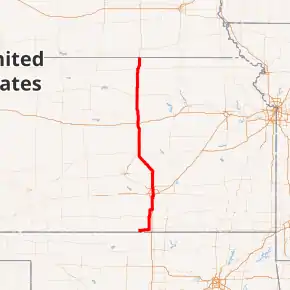
US-81 highlighted in red | ||||
| Route information | ||||
| Maintained by KDOT and the cities of Wellington, Wichita, and Concordia | ||||
| Major junctions | ||||
| South end | ||||
| North end | ||||
| Location | ||||
| Counties | Sumner, Sedgwick, Harvey, McPherson, Saline, Ottawa, Cloud, Republic | |||
| Highway system | ||||
| ||||

Route description
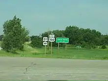
Nearly all of US-81 in Kansas is either freeway or expressway. The route enters Kansas as a two-lane near Caldwell. From South Haven to Wichita it closely parallels Interstate 35, which is also known as the Kansas Turnpike in that area. After South Haven, the only town of any significance along US 81 until Wichita is Wellington, which is just west of the Turnpike along U.S. Route 160.
.jpg.webp)
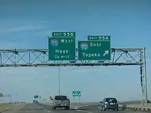
At Wichita, US-81 joins Interstate 135. The two highways remain joined until Salina, with I-135's mile markers taking precedence. Interstate 135 ends at Interstate 70 but US-81 continues as a freeway to Minneapolis, then as an expressway passing through Concordia before exiting the state north of Belleville.
All but 5.3 miles (9 km) of US-81's alignment is maintained by KDOT. The entire 3.128-mile (5.034 km) section within Wellington is maintained by the city.[1] The section within Wichita from the south city limit to I-135 is maintained by the city.[2] The entire 2.123-mile (3.417 km) section within Concordia is maintained by the city.[3]
History
The alignment of US-81 from Wichita to Salina prior to the completion Interstate 135 is fully intact. The prior alignment ran from where current US-81 breaks off for Interstate 135 at 47th street, north through Wichita along Broadway street. Old US-81 roughly parallels Interstate 135 to Newton. Old US-81 follows current K-15 through Newton between an interchange with US-50 and Hesston Road, where old US-81 breaks northwest onto Hesston road. Old US-81 then travels through the small Kansas towns of Hesston, Moundridge, and Elyria, before turning to the north, and going through the town of McPherson as Main street. North of McPherson, old US-81 continues to Lindsborg, where it follows current K-4 until an interchange with Interstate 135. Old US-81 passes under Interstate 135 and continues to parallel it about 1/2 mile to the east. Old US-81 then travels through Assaria, where it encounters another brief overlap with K-4 and K-104. Old US-81 continues through the city of Salina as Ninth street. North of Salina, Old US-81 encounters brief overlaps with K-143 and K-18. Old US-81 follows K-106 to an interchange with current US-81, where the two alignments are joined back together.
| |
|---|---|
| Location | Wichita |
| Length | 0.466 mi (0.750 km) |
| Existed | June 8, 1960[4]–c. 1979 |
In a June 8, 1960 resolution, K-225 was assigned from US-81 east to I-35W (modern I-135).[4] K-225 became a section of US-81 by 1979, when US-81 was moved from its former alignment in Wichita to run along I-135.[5][6][7]
K-226 was first designated as a state highway in a March 8, 1961 resolution.[8] The highway remained the same, then between 1979 and 1981, US-81 had been realigned onto I-35W and at this time K-226 was decommissioned.[6][9]
| |
|---|---|
| Location | Near Lindsborg |
| Existed | August 24, 1966–March 29, 1961 |
In an August 24, 1966 resolution, a section of the new I-35W was to be built south of Lindsborg. At this time, K-155 was proposed to connect US-81 to the new I-35W. This plan was later cancelled in a March 29, 1961 meeting, when US-81 was realigned onto I-35W to current exit 72, then west along the proposed K-155 (modern Smoky Valley Road) to the old US-81 alignment.[10]
From Salina to the Nebraska state line, the highway is named the Frank Carlson Memorial Highway, in honor of the late Senator Frank Carlson. Senator Carlson was a native of Concordia who represented Kansas in the U.S. Senate from 1951-1969. Before serving in the Senate, he was Governor of Kansas from 1947–1950.
Major intersections
| County | Location | mi | km | Exit | Destinations | Notes | |
|---|---|---|---|---|---|---|---|
| Sumner | Caldwell Township | 0.000 | 0.000 | Continuation into Oklahoma | |||
| Caldwell | Southern terminus of K-49 | ||||||
| South Haven | Northern terminus of US-177 | ||||||
| Western terminus of US-166 | |||||||
| Wellington | Southern terminus of US-160 concurrency | ||||||
| North Washington Avenue – Business District | Former routing of US-81 | ||||||
| Roundabout; northern terminus of US-160 concurrency | |||||||
| Belle Plaine Township | Western terminus of K-55 | ||||||
| Sumner–Sedgwick county line | Belle Plaine–Salem township line | Western terminus of K-53 | |||||
| Sedgwick | Wichita | ||||||
| Tolled; south end of freeway section; southern terminus of I-135 concurrency; I-135 exit 1A | |||||||
| Overlap with I-135 | |||||||
| Saline | Salina | 95A-B | Northern terminus of I-135 concurrency; northern terminus of I-135; I-70 exit 250A-B; I-135 exit 95A-B; cloverleaf interchange | ||||
| Elm Creek Township | — | Northern terminus of K-143 | |||||
| Ottawa | Bennington Township | — | |||||
| Concord Township | — | North end of freeway section | |||||
| Logan Township | Eastern terminus of K-41 | ||||||
| Cloud | Meredith Township | Interchange | |||||
| Concordia | |||||||
| Republic | Lincoln Township | ||||||
| Belleville | Interchange | ||||||
| Liberty Township | Continuation into Nebraska | ||||||
1.000 mi = 1.609 km; 1.000 km = 0.621 mi
| |||||||
References
- Kansas Department of Transportation (January 9, 2008). "Resolution Designating City Connecting Links in State Highway System". Topeka: Kansas Department of Transportation. Retrieved September 9, 2020.
- Kansas Department of Transportation (July 18, 2017). "Resolution Designating City Connecting Links in State Highway System". Topeka: Kansas Department of Transportation. Retrieved September 9, 2020.
- Kansas Department of Transportation (September 19, 2001). "Resolution Designating City Connecting Links in State Highway System". Topeka: Kansas Department of Transportation. Retrieved September 9, 2020.
- State Highway Commission of Kansas (June 8, 1960). "Resolution for location and designation". Topeka: State Highway Commission of Kansas. Retrieved April 19, 2020.
- State Highway Commission of Kansas (1978). Kansas State Highway System (PDF) (Map). Scale not given. Topeka: State Highway Commission of Kansas. Retrieved April 22, 2020.
- State Highway Commission of Kansas (1979). Kansas State Highway System (PDF) (Map) (1979–1980 ed.). Scale not given. Topeka: State Highway Commission of Kansas. Retrieved April 22, 2020.
- Bureau of Transportation Planning (1978). Sedgwick County (PDF) (Map). General Highway Map. Topeka: Kansas Department of Transportation. Retrieved April 22, 2020.
- State Highway Commission of Kansas (March 8, 1961). "Resolution for location and desegnation of road in Sedgwick County". Topeka: State Highway Commission of Kansas. Retrieved April 22, 2020.
- State Highway Commission of Kansas (1981). Kansas State Highway System (PDF) (Map) (1981–1982 ed.). Scale not given. Topeka: State Highway Commission of Kansas. Retrieved April 30, 2020.
- State Highway Commission of Kansas (August 24, 1966). "Resolution for location, relocation and redesignation of roads using State-wide Funds as follows". Topeka: State Highway Commission of Kansas. Retrieved April 28, 2020.