K-111 (Kansas highway)
K-111 is a 5.334-mile-long (8.584 km) state highway in the U.S. state of Kansas. K-111's southern terminus is at F Street at the Kanopolis city limits, and the northern terminus is at K-156 northeast of the city of Ellsworth. Along the way it intersects K-140 north of Kanopolis. K-111 travels through mostly flat rural farmlands south of K-140, and small rolling hills covered with grasslands north of K-140. It is a two-lane highway its entire length.[3]
| ||||
|---|---|---|---|---|
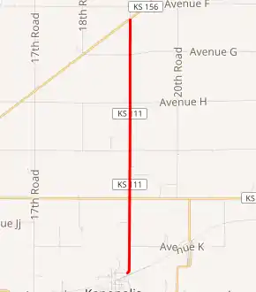
K-111 highlighted in red | ||||
| Route information | ||||
| Maintained by KDOT | ||||
| Length | 5.334 mi[1] (8.584 km) | |||
| Existed | September 28, 1948[2]–present | |||
| Major junctions | ||||
| South end | F Street at Kanopolis city limits | |||
| North end | ||||
| Location | ||||
| Counties | Ellsworth | |||
| Highway system | ||||
| ||||

When K-111 was first designated a state highway on September 28, 1948, as a short spur between Kanopolis and U.S. Route 40 (US-40), which is modern K-140. On October 13, 1967, US-40 was rerouted to overlap the newly constructed section of I-70 from Dorrance to Salina. At that time K-111 was extended northward to US-156, which is modern K-156. Then on November 27, 1968, old US-40 from Ellsworth eastward to Salina was designated K-140. In an October 13, 1979 AASHTO meeting, it was approved to remove US-156 as a U.S. highway. Then on April 4, 1981, US-156 was redesignated as K-156.[4]
Route description
K-111 begins at the Kanopolis city limits as a continuation of F Street. As it leaves the city, K-111 curves north and travels through flat rural farmlands.[5] It continues northward and soon crosses over an unnamed creek that is bordered by trees. The highway continues a little over .5 miles (0.80 km) through more farmland before reaching an intersection with K-140. K-140 heads west to Ellsworth and east to Salina. As K-111 continues north, the landscape transitions to rolling hills mixed with grasslands and some farmlands. After roughly 1.3 miles (2.1 km) it begins to parallel to the east of East Spring Creek, a tributary of Spring Creek which flows into Smoky Hill River. The river then passes under the highway about .7 miles (1.1 km) later and continues to parallel it. K-111 continues north for roughly 1.4 miles (2.3 km) through rolling hills covered with grasslands then crosses East Spring Creek again. It then continues another roughly .3 miles (0.48 km) before reaching its northern terminus at K-156. K-156 heads west to Ellsworth and east to I-70 and US-40.[3]
The Kansas Department of Transportation (KDOT) tracks the traffic levels on its highways, and in 2017, they determined that on average the traffic varied from 225 vehicles per day slightly north of the junction with K-140 to 465 vehicles per day slightly south of the junction with K-140.[6] K-111 is not included in the National Highway System.[7] The National Highway System is a system of highways important to the nation's defense, economy, and mobility. K-111 does connect to the National Highway System at its northern terminus at K-156.[8] The entire route is paved with partial design bituminous pavement.[1][9]
History
Early roads
Before state highways were numbered in Kansas there were auto trails, which were an informal network of marked routes that existed in the United States and Canada in the early part of the 20th century. K-111 intersects K-140, which follows the Golden Belt Highway.[10]
Establishment and realignments
K-111 was first designated a state highway by KDOT, at the time State Highway Commission of Kansas, on September 28, 1948. At that time it ran from US-40 (modern K-140) southward and ended at the Kannapolis city limits.[2][11] On October 13, 1967, US-40 was rerouted to overlap the newly constructed section of I-70 from Dorrance to Salina. At that time K-111 was extended northward 3.8 miles (6.1 km) to US-156, now K-156.[4] Then on November 27, 1968, old US-40 from Ellsworth eastward to Salina was designated K-140 and K-141 was truncated to end at the new K-140.[12] In an October 13, 1979 AASHTO meeting, it was approved to remove US-156 as a U.S. highway. Then in an April 4, 1981 resolution, US-156 was redesignated as K-156 by KDOT.[13]
Major intersections
The entire route is in Ellsworth County.
| Location | mi[1] | km | Destinations | Notes | |
|---|---|---|---|---|---|
| Ellsworth Township | 0.000 | 0.000 | F Street | Continuation west into Kanopolis at city limits | |
| Ellsworth–Clear Creek township line | 1.583 | 2.548 | Former US-40; to I-135 via K-140 east | ||
| Garfield–Sherman township line | 5.334 | 8.584 | Northern terminus; former US-156; to I-70 via K-156 east; road continues unpaved as 19th Road | ||
| 1.000 mi = 1.609 km; 1.000 km = 0.621 mi | |||||
References
- Staff (2016). "Pavement Management Information System". Kansas Department of Transportation. Retrieved April 16, 2017.
- State Highway Commission of Kansas (1948). "Resolution to add road in Ellsworth County to State Highway System". State Highway Commission of Kansas.
- Highway Planning Department (2011). Ellsworth County (PDF) (Map). Scale not given. General Highway Map. Topeka: Kansas Department of Transportation. Retrieved August 22, 2019.
- State Highway Commission of Kansas (October 13, 1967). "Resolution for Relocation and Redesignation of Road in Russell, Ellsworth and Saline Counties". Topeka: State Highway Commission of Kansas. Retrieved August 22, 2019.
- Bureau of Transportation Planning (February 2011). City of Kanopolis (PDF) (Map). Scale not given. KDOT City Maps. Topeka: Kansas Department of Transportation. Retrieved August 24, 2020.
- Bureau of Transportation Planning (2018). Traffic Flow Map Kansas State Highway System (PDF) (Map). [c. 1:1,584,000]. Topeka: Kansas Department of Transportation. Retrieved July 29, 2019.
- Federal Highway Administration (May 8, 2019). National Highway System: Kansas (PDF) (Map). [c. 1:3,900,000]. Federal Highway Administration. Retrieved July 29, 2019.
- Natzke, Stefan; Neathery, Mike; Adderly, Kevin (September 26, 2012). "What is the National Highway System?". National Highway System. Federal Highway Administration. Retrieved July 29, 2019.
- Staff (2012-05-09). "Pavement Management Information System Glossary". Kansas Department of Transportation.
- Rand McNally and Company (1924). "Kansas" (Map). AutoTrails Map, Southern Nebraska, Eastern Colorado, Kansas, Northeastern New Mexico, Northern Oklahoma. 1:1,600,000. Chicago: Rand McNally and Company. OCLC 2078375. Retrieved June 15, 2020 – via Rumsey Collection.
- Highway Planning Department (1953). Ellsworth County (PDF) (Map). Scale not given. General Highway Map. Topeka: State Highway Commission of Kansas. Retrieved August 22, 2019.
- State Highway Commission of Kansas (November 27, 1968). "Resolution for Location and Redesignation of Road in Ellsworth and Saline Counties". Topeka: State Highway Commission of Kansas. Retrieved August 22, 2019.
- Kansas Department of Transportation (April 1, 1981). "Resolution for Redesignation of Road". Topeka: Kansas Department of Transportation. Retrieved August 22, 2019.