K-156 (Kansas highway)
K-156 is a 175.663-mile-long (282.702 km) west–east state highway in the U.S. state of Kansas. K-156's western terminus is at U.S. Route 50 Business (US 50 Bus.) and US 83 Bus. in Garden City and the eastern terminus is at Interstate 70 (I-70) and U.S. Route 40 (US 40) northeast of Ellsworth. Along the way, it intersects several major highways including US 50, US 83 and US 400 in Garden City; US 283 in Jetmore; and US 183 near Rozel, and it overlaps its implied parent, US 56, from Larned to east of Great Bend.
| ||||
|---|---|---|---|---|
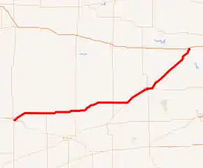
K-156 highlighted in red | ||||
| Route information | ||||
| Maintained by KDOT and the cities of Garden City, Larned and Great Bend | ||||
| Length | 175.663 mi[1] (282.702 km) | |||
| Existed | April 1, 1981[2]–present | |||
| Tourist routes | ||||
| Major junctions | ||||
| West end | ||||
| East end | ||||
| Location | ||||
| Counties | Finney, Hodgeman, Pawnee, Barton, Ellsworth | |||
| Highway system | ||||
| ||||

Before state highways were numbered in Kansas, there were auto trails; the section of K-156 from Larned to Great Bend followed the National Old Trails Road and Old Santa Fe Trail. By 1927, the section of K-156 from Garden City to Great Bend was established as US 50N. K-156 was originally US 156, an intrastate U.S. Highway that was formed in 1957 and ran from Garden City to Great Bend. Between 1966 and 1967, US 156 was extended northeast, along K-45, to I-70 northeast of Ellsworth. On April 1, 1981, US 156 was redesignated K-156.[2] On May 3, 1996, US 400 was established from the Colorado border to the southern end of the overlap between US 83 and US 50 in Garden City. Its alignment has not been majorly altered since.
Route description
K-156 begins at US 50 Bus. and US 83 Bus. in Garden City and runs in a generally northeast direction to I-70 and US 40 northeast of Ellsworth. K-156 is signed as east–west its entire length. According to 2018 traffic counts conducted by the Kansas Department of Transportation, on average, traffic varied from 1,080 vehicles per day slightly east of the Finney–Hodgeman county line to 14,500 vehicles per day in Great Bend, slightly west of US 281. The second highest volume of traffic was 11,500 vehicles per day, at the western terminus.[3][4] The section of K-156 from the western end of the overlap with US 56 to its eastern terminus is included in the National Highway System.[5] K-156 also connects to the National Highway System at its junction with US 50, US 83 and US 400 in Garden City.[6]
All but 5.973 miles (10 km) of K-156's 175.663-mile (283 km) alignment is maintained by KDOT. The first .465 miles (1 km) from the western terminus eastward is maintained by Garden City.[7] The entire 1.409-mile (2 km) section of K-156 in Larned and the entire 4.099-mile (7 km) section of K-156 through Great Bend are maintained by the cities.[8][9]
Finney and Hodgeman counties

The route begins in Garden City, on Kansas Avenue at the junction with US 50 Business and US 83 Business (Main Street). The highway continues over Kansas Avenue then turns northeast at a junction with Campus Drive. K-156 then intersects US 50, US 83 and US 400 via a diamond interchange and then continues to follows Kansas Avenue in a northeast direction out of the city.[10] It then curves east at East 6 Mile Road, then intersects Mennonite Road 1.7 miles (2.7 km) later. From here, the highway continues east for about eleven miles (18 km) through rural farmlands before intersecting K-23, passing by Concannon State Fishing Lake and crossing Pawnee River along the way. Here K-156 begins a six-mile-long (9.7 km) overlap with K-23. At the end of the overlap K-23 turns south toward Cimarron, as K-156 continues east. K-156 then passes through Kalvesta, then curves to the northeast as it crosses into Hodgeman County.[11] About one mile (1.6 km) into the county, K-156 curves back to the east, then crosses Sand Creek 1.5 miles (2.4 km) later. Roughly 10.4 miles (16.7 km) further east the highway curves northeast for about one-mile (1.6 km) then curves back east. The highway continues another 3.5 miles (5.6 km) then enters Jetmore. In Jetmore it intersects US 283, also known as Main Street.[12] As it exits the city it travels a short distance then curves to the northeast at Bosse. The roadway then curves more to the northeast and passes to the north of Hanston. As it passes by Hanston, K-156 curves east briefly then back northeast as it begins to parallel a Kansas and Oklahoma Railroad track.[13] About three miles (4.8 km) later, the highway passes through Gray. It continues past Gray for another 3.5 miles (5.6 km) then enters into Pawnee County.[14][15]
Pawnee County
As it enters the county it continues to parallel a Kansas and Oklahoma Railroad track and the Pawnee River. After about 1.4 miles (2.3 km) K-156 curves east, passes to the north of Rucker Airport, then enters the southern section of Burdett as Broadway Avenue.[16] It exits the city and continues east, crosses Sawmill Creek, then reaches an intersection with Pawnee Street and 280th Avenue just south of Rozel. About three miles (4.8 km) past Rozel it crosses a railroad track. From here the highway continues east through rural farmlands to US 183, crossing the Pawnee River and Cocklebur Creek along the way. It continues east for about nine miles (14 km) before intersecting K-264, passing Fort Larned National Historic Site along the way. K-264 heads south to Larned State Hospital, and K-156 continues east toward Larned. It enters Larned becoming Edwards Street then becomes 14th Street at an intersection with State Street. It continues along 14th Street and soon intersects its implied parent US 56, at Broadway Street. Here the two highways begin to overlap as they continue east. The two routes curve northeast as they exit the city and begin to parallel a Kansas and Oklahoma Railroad track.[17] The highways then cross Ash Creek and enters Barton County 1.5 miles (2.4 km) later.[15][18]
Barton and Ellsworth counties
As K-156 enters the county it enters the city of Pawnee Rock.[19] It continues northeast and soon passes Dundee. As it exits Dundee it passes to the south of Great Bend Municipal Airport. K-156 and US 56 then curve north and enter Great Bend as South Patton Road. The highways turn east at 10th Street then soon intersects and begins to overlap with K-96. The three roads continue east along 10th Street for 1.8 miles (2.9 km) to an intersection with US 281 (Main Street), crossing a Kansas and Oklahoma Railroad track along the way. After the three highways cross US 281, they leave Great Bend and 2.2 miles (3.5 km) later, K-156 splits from US 56 and K-96, heading northeast from there.[20] K-156 passes to the east of Cheyenne Bottoms Reservoir, crosses a Kansas and Oklahoma Railroad, then intersects K-4 at a folded diamond interchange east of Claflin. After an interchange with K-4, the highway enters Ellsworth County two miles (3.2 km) later.[21] The highway enters the county and continues northeast before entering Holyrood.[22] As it exits the city, it continues through rural farm lands transitioning into grasslands, and soon intersects K-14 south of Ellsworth. At that junction, K-156 begins carrying a concurrency with K-14 Truck route. The two routes then cross the Smoky Hill River and a Union Pacific Railroad track then enter Ellsworth. Inside the city the two highways curve north at an intersection with 8th Street. The highway passes Memorial Cemetery and soon intersects K-140, known as East 15th Street westbound and Avenue J eastbound. Here, K-14 Truck splits from K-156 and follows K-140 westbound, and K-156 continues north. The highway soon exits the city and continues north for about .8 miles (1.3 km) then curves northeast and crosses Oak Creek.[23] K-156 then reaches a junction with K-111, crossing Spring Creek and East Spring Creek along the way. Past K-111, the landscape around the highway begins to transition to rolling hills covered by grasslands. K-156 then crosses and begins to parallel East Elkhorn Creek. It continues north along the creek for a few miles before reaching its northern terminus at exit 225 of I-70 and US 40 at a diamond interchange.[15][24]
History
Before state highways were numbered in Kansas, there were auto trails, which were an informal network of marked routes that existed in the United States and Canada in the early part of the 20th century. From the western terminus, K-156 closely follows the former Old Santa Fe Trail, New Santa Fe Trail, National Old Trails Road and Albert Pike Highway. In Jetmore, K-156 intersects the former Star Highway. The highway then overlaps the National Old Trails Road and Old Santa Fe Trail from Larned to Great Bend. East of Claflin, the highway crosses the former Bee Line and Sunflower Trail, then crosses the former Golden Belt in Ellsworth.[25]
| |
|---|---|
| Existed | June 27, 1956[26]–April 1, 1981[2] |
By 1927, the section of modern K-156 from Garden City to Great Bend was established as US 50N.[27] Between 1944 and 1945, the section of current K-156 between Holyrood to south of Ellsworth was established as a section of K-45.[28][29] In the early 1950s, towns along what was then the K-45 corridor, connecting Ellsworth, Kansas to the Oklahoma state line at Elkhart, formed the Mid-Continent Diagonal Highway Association[30] to push for a new highway from Springer, New Mexico (on US 85) northeast across the Oklahoma Panhandle, along K-45, and continuing to Manitowoc, Wisconsin on Lake Michigan.[31] By mid-1954, it was being promoted as US 55 between the Great Lakes and the Southwestern United States.[32] The first submissions to the American Association of State Highway Officials (AASHO) to establish the route were made in 1954. The first route considered in northeast Kansas was via US 40 from Ellsworth to Topeka and K-4 and US 59 via Atchison to St. Joseph, Missouri.[33] A revised route adopted in March 1955, due to AASHO objections to the original route, which traveled concurrently with other U.S. highways for over half of its length, followed K-14, K-18, US 24, K-63, K-16, and US 59 via Lincoln and Manhattan.[34] In July, the US 50N Association proposed a plan that would have eliminated US 50N by routing US 55 along most of its length, from Larned east to Baldwin Junction, and then along US 59 to Lawrence and K-10 to Kansas City; towns on US 50N west of Larned, which would have been bypassed, led a successful fight against this.[35][36] However, in September of that year, the Kansas Highway Commission accepted that plan, taking US 55 east to Kansas City.[37] On June 27, 1956, the AASHO Route Numbering Committee considered this refined plan for US 55, between Springer, New Mexico and Kansas City, Missouri, with a short US 155 along the remaining portion of US 50N from Larned west to Garden City. The committee approved the request, but since the proposed route was more east–west than north–south, it changed it to an even number – US 56 – and the spur to US 156.[26]
Between 1962 and 1963, K-45 was extended to US 56 east of Great Bend.[38][39] Then between 1966 and 1967, US 156 was extended northeast, along K-45, to I-70 northeast of Ellsworth.[40][41] Until 1965, the section of the highway from Great Bend to Ellsworth County was designated K-45.[42] In a July 1966 meeting, US 156 was extended north from Ellsworth to the new I-70 that was constructed.[43] In a resolution on October 13, 1967, US 40 between I-70 north of Dorrance to I-70 north of Salina was realigned onto I-70. At this time K-111 was extended north to end at US 156.[44] Between 1975 and 1980, a folded diamond interchange was constructed at the junction with K-4.[45][46] In a December 17, 1980 resolution, US 50 and US 83 were moved to their current alignment in Garden City, and US 50 Business and US 83 Business became US 156's western terminus.[47]
The entirety of US 156, from Garden City to I-70 northeast of Ellsworth, was decommissioned on April 1, 1981, and redesignated as K-156.[2] In a May 3, 1996 resolution, US 400 was established from the Colorado border to K-156, then to the southern end of the overlap between US 83 and US 50 in Garden City.[48] On July 6, 2020, work began on a project to add turning lanes at the interchange with Eighth Street in Ellsworth County. The $1.2 million project was completed by Venture Corporation of Great Bend.[49]
Major intersections
| County | Location | mi[1] | km | Destinations | Notes |
|---|---|---|---|---|---|
| Finney | Garden City | 0.000 | 0.000 | Western terminus | |
| 1.936 | 3.116 | Diamond interchange | |||
| | 24.210 | 38.962 | Western end of K-23 overlap | ||
| | 30.190 | 48.586 | Eastern end of K-23 overlap | ||
| Hodgeman | Jetmore | 56.069 | 90.234 | ||
| Pawnee | | 89.939 | 144.743 | ||
| | 98.908 | 159.177 | Northern terminus of K-264 | ||
| Larned | 101.734 | 163.725 | Western end of US 56 overlap | ||
| Barton | Great Bend | 122.153 | 196.586 | Western end of K-96 overlap | |
| 123.930 | 199.446 | ||||
| | 127.725 | 205.553 | Eastern end of US 56/K-96 overlap | ||
| | 142.989 | 230.118 | Folded diamond interchange | ||
| Ellsworth | | 162.671 | 261.794 | Southern terminus of K-14 Truck; west end of K-14 Truck overlap | |
| Ellsworth | 163.747 | 263.525 | Kanopolis | Partial interchange; access via westbound exit ramp and connector road | |
| 164.966 | 265.487 | East end of K-14 Truck overlap | |||
| | 170.417 | 274.260 | Northern terminus of K-111 | ||
| | 175.663 | 282.702 | Eastern terminus; I-70 exit 225; diamond interchange | ||
1.000 mi = 1.609 km; 1.000 km = 0.621 mi
| |||||
References
- Staff (2016). "Pavement Management Information System". Kansas Department of Transportation. Retrieved May 5, 2017.
- Resolution to redesignate a Highway (Map). KDOT. Retrieved August 2, 2019.
- Bureau of Transportation Planning (2019). Traffic Flow Map Kansas State Highway System (PDF) (Map). [c. 1:1,584,000]. Topeka: Kansas Department of Transportation. Retrieved August 10, 2020.
- Bureau of Transportation Planning (2019). Traffic Flow Inset Map Kansas State Highway System (PDF) (Map). [c. 1:1,584,000]. Topeka: Kansas Department of Transportation. Retrieved August 10, 2020.
- Federal Highway Administration (May 8, 2019). National Highway System: Kansas (PDF) (Map). [c. 1:3,900,000]. Federal Highway Administration. Retrieved August 10, 2020.
- Natzke, Stefan; Neathery, Mike; Adderly, Kevin (September 26, 2012). "What is the National Highway System?". National Highway System. Federal Highway Administration. Retrieved August 10, 2020.
- State Highway Commission of Kansas (August 14, 2000). "Resolution Designating City Connecting Links in State Highway System". Topeka: State Highway Commission of Kansas. Retrieved September 5, 2020.
- State Highway Commission of Kansas (April 1, 1981). "Resolution Designating City Connecting Links in State Highway System". Topeka: State Highway Commission of Kansas. Retrieved September 5, 2020.
- State Highway Commission of Kansas (July 20, 2012). "Resolution Designating City Connecting Links in State Highway System". Topeka: State Highway Commission of Kansas. Retrieved September 5, 2020.
- Bureau of Transportation Planning (April 2011). City of Garden City (PDF) (Map). Scale not given. KDOT City Maps. Topeka: Kansas Department of Transportation. Retrieved August 24, 2020.
- Bureau of Transportation Planning (July 2007). Finney County (PDF) (Map). [c. 1: 211,200]. General Highway Map. Topeka: Kansas Department of Transportation. Retrieved August 10, 2020.
- Bureau of Transportation Planning (December 2008). City of Jetmore (PDF) (Map). Scale not given. KDOT City Maps. Topeka: Kansas Department of Transportation. Retrieved August 24, 2020.
- Bureau of Transportation Planning (October 2003). City of Hanston (PDF) (Map). Scale not given. KDOT City Maps. Topeka: Kansas Department of Transportation. Retrieved August 24, 2020.
- Bureau of Transportation Planning (December 2008). Hodgeman County (PDF) (Map). [c. 1: 211,200]. General Highway Map. Topeka: Kansas Department of Transportation. Retrieved August 10, 2020.
- Google (August 10, 2020). "Overview map of K-156" (Map). Google Maps. Google. Retrieved August 10, 2020.
- Bureau of Transportation Planning (April 2008). City of Burdett (PDF) (Map). Scale not given. KDOT City Maps. Topeka: Kansas Department of Transportation. Retrieved August 24, 2020.
- Bureau of Transportation Planning (December 2001). City of Larned (PDF) (Map). Scale not given. KDOT City Maps. Topeka: Kansas Department of Transportation. Retrieved August 24, 2020.
- Bureau of Transportation Planning (October 2010). Pawnee County (PDF) (Map). [c. 1: 211,200]. General Highway Map. Topeka: Kansas Department of Transportation. Retrieved August 10, 2020.
- Bureau of Transportation Planning (January 2002). City of Pawnee Rock (PDF) (Map). Scale not given. KDOT City Maps. Topeka: Kansas Department of Transportation. Retrieved August 24, 2020.
- Bureau of Transportation Planning (April 2007). City of Great Bend (PDF) (Map). Scale not given. KDOT City Maps. Topeka: Kansas Department of Transportation. Retrieved August 24, 2020.
- Bureau of Transportation Planning (September 2009). Barton County (PDF) (Map). [c. 1: 211,200]. General Highway Map. Topeka: Kansas Department of Transportation. Retrieved August 10, 2020.
- Bureau of Transportation Planning (February 2011). City of Holyrood (PDF) (Map). Scale not given. KDOT City Maps. Topeka: Kansas Department of Transportation. Retrieved August 24, 2020.
- Bureau of Transportation Planning (March 2011). City of Ellsworth (PDF) (Map). Scale not given. KDOT City Maps. Topeka: Kansas Department of Transportation. Retrieved August 24, 2020.
- Bureau of Transportation Planning (July 2011). Ellsworth County (PDF) (Map). [c. 1: 211,200]. General Highway Map. Topeka: Kansas Department of Transportation. Retrieved August 10, 2020.
- Rand McNally and Company (1924). "Kansas" (Map). AutoTrails Map, Southern Nebraska, Eastern Colorado, Kansas, Northeastern New Mexico, Northern Oklahoma. 1:1,600,000. Chicago: Rand McNally and Company. OCLC 2078375. Retrieved August 10, 2020 – via Rumsey Collection.
- Oklahoma Department of Transportation, Chronological History Documentation: US 56 (correspondence between ODOT, AASHO, and other DOTs)
- Rand McNally and Company (1927). "Kansas" (Map). Rand McNally Auto Road Atlas of the United States and Ontario, Quebec, and the Maritime Provinces of Canada, with a Brief Description of the National Parks and Monuments. 1:1,600,000. Chicago: Rand McNally and Company. pp. 54–55. OCLC 2078375 – via Rumsey Collection.
- State Farm Insurance Companies Travel Bureau (1944). "Kansas" (Map). State Farm Road map: Kansas. 1:1,235,520. Chicago: Rand McNally and Company. Retrieved August 10, 2020 – via Rumsey Collection.
- State Highway Commission of Kansas (1945). Kansas State Highway System (PDF) (Map). Scale not given. Topeka: State Highway Commission of Kansas. Retrieved August 10, 2020.
- "Highway Assured". Atchison Daily Globe. December 17, 1953. p. 20. Retrieved October 7, 2020 – via Newspapers.com.
- "Vernon Tip Traylor..." Great Bend Daily Tribune. October 1, 1953. p. 1. Retrieved October 7, 2020 – via Newspapers.com.
- "New Mexico Okays US-55 Road Proposal". Great Bend Daily Tribune. June 2, 1954. p. 7. Retrieved October 7, 2020 – via Newspapers.com.
- "Another Effort to Reroute Proposed Federal Highway". Great Bend Daily Tribune. January 6, 1955. Retrieved October 7, 2020 – via NewspaperArchive.
- "New US-55 Route Approved Here". Great Bend Daily Tribune. March 20, 1955. p. 3. Retrieved October 7, 2020 – via Newspapers.com.
- "Call Meeting On Road Proposals". Great Bend Daily Tribune. July 26, 1955. p. 1. Retrieved October 7, 2020 – via Newspapers.com.
- "US 50N Boosters Turn Down New Route, Name". Great Bend Daily Tribune. July 29, 1955. Retrieved October 7, 2020 – via Newspapers.com.
- "Highway Boosters Here Oppose New US-55 Plan". Great Bend Daily Tribune. September 16, 1955. Retrieved October 7, 2020 – via NewspaperArchive.
- State Highway Commission of Kansas (1962). Kansas State Highway System (PDF) (Map). Scale not given. Topeka: State Highway Commission of Kansas. Retrieved August 10, 2020.
- State Highway Commission of Kansas (1963–1964). Kansas State Highway System (PDF) (Map). Scale not given. Topeka: State Highway Commission of Kansas. Retrieved August 10, 2020.
- State Highway Commission of Kansas (1966). Kansas State Highway System (PDF) (Map). Scale not given. Topeka: State Highway Commission of Kansas. Retrieved August 10, 2020.
- State Highway Commission of Kansas (1967). Kansas State Highway System (PDF) (Map). Scale not given. Topeka: State Highway Commission of Kansas. Retrieved August 10, 2020.
- 1965 Kansas State Highway Map
- State Highway Commission of Kansas (July 18, 1966). "Resolution for Location and Designation of Road in Ellsworth County". Topeka: State Highway Commission of Kansas. Retrieved August 10, 2020.
- State Highway Commission of Kansas (October 13, 1967). "Resolution for Relocation and Redesignation of Road in Russell, Ellsworth and Saline Counties". Topeka: State Highway Commission of Kansas. Retrieved August 10, 2020.
- Bureau of Transportation Planning (1975). Barton County (PDF) (Map). [c. 1: 211,200]. General Highway Map. Topeka: Kansas Department of Transportation. Retrieved August 24, 2020.
- Bureau of Transportation Planning (1980). Barton County (PDF) (Map). [c. 1: 211,200]. General Highway Map. Topeka: Kansas Department of Transportation. Retrieved August 24, 2020.
- State Highway Commission of Kansas (December 17, 1980). "Resolution for Relocation and Redesignation of highways in Finney County". Topeka: State Highway Commission of Kansas. Retrieved August 10, 2020.
- Kansas Department of Transportation (May 3, 1996). "Resolution to establish Highway US 400 in Hamilton, Keeney, and Finney counties". Topeka: Kansas Department of Transportation. Retrieved August 10, 2020.
- "KDOT to add turning lanes on K-156 in Ellsworth County". salinapost.com. April 4, 2020. Retrieved August 10, 2020.