K-190 (Kansas highway)
K-190 is a 24.172-mile-long (38.901 km) east–west state highway in the U.S. state of Kansas. K-190's western terminus is at U.S. Route 160 (US-160) east of the community of Hickok, and the eastern terminus is at US-83 and US-160 south of the city of Sublette. K-190 travels mostly through flat rural farmland, however it does run through the city of Satanta where it is co-designated as US-56. K-190 was first designated as a state highway on December 22, 1954.
| ||||
|---|---|---|---|---|
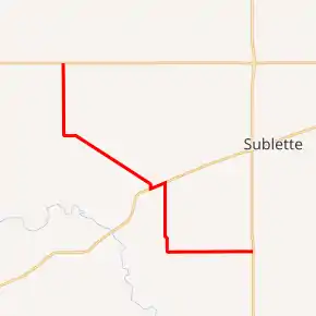
K-190 highlighted in red | ||||
| Route information | ||||
| Maintained by KDOT | ||||
| Length | 24.172 mi[1] (38.901 km) | |||
| Existed | December 22, 1954[2][3][4]–present | |||
| Major junctions | ||||
| West end | ||||
| East end | ||||
| Location | ||||
| Counties | Grant, Haskell, Seward | |||
| Highway system | ||||
| ||||

Route description
K-190 begins at an intersection with US-160 east of Hickok. It begins traveling southward through flat rural farmlands then after roughly 4.45 miles (7.16 km) crosses the Cimarron Valley Railroad (CVRR) in Ryus. It continues approximately 0.5 miles (0.80 km) then curves to the east. The highway continues roughly .8 miles (1.3 km) then curves southeast and begins to parallel the CVRR. It continues about .2 miles (0.32 km) then crosses into Haskell County.[5] It continues approximately 5.9 miles (9.5 km) then curves south, away from the railroad, at County Road Ff. It continues roughly .2 miles (0.32 km), crosses the CVRR, then intersects US-56 at the Satanta city limits.
Here, K-190 turns northeast and begins to overlap US-56. The two routes continue through Satanta as Nez Perce Street for about 1.08 miles (1.74 km) then reaches the east city limit.[6] At this point K-190 turns south, as US-56 continues northeast. K-190 continues south through flat rural farmlands for roughly 3.7 miles (6.0 km) then curves southeast and enters into Seward County.[7] As the highway enters the county it curves south and continues for roughly .9 miles (1.4 km) then curves east at County Road F. K-190 continues east through flat rural farmlands for roughly 5.9 miles (9.5 km) then reaches its eastern terminus at US-83 and US-160.[8]
The Kansas Department of Transportation (KDOT) tracks the traffic levels on its highways, and in 2017, they determined that on average the traffic varied from 200 vehicles per day near the eastern terminus to 1425 vehicles per day along the concurrency with US-56.[9] K-190 is not included in the National Highway System.[10] The National Highway System is a system of highways important to the nation's defense, economy, and mobility. K-190 does connect to the National Highway System at its eastern terminus at US-83 and US-160.[11] The entire route is paved with partial design bituminous pavement except the section concurrent with US-56, which is composite pavement.[1][12]
History
In three separate resolutions on August 11, 1954, it was passed, that once Grant, Haskell and Seward Counties had furnished a right of way of 100 feet wide that the road would be added to the state highway system.[2][3][4] Haskell County finished their section by November 1, 1954,[3] Grant County by December 6, 1954,[2] and Seward County by December 20, 1954.[4] Then in a December 22, 1954 resolution, the road was designated as K-190 and added to the state highway system.[2][3][4] When the highway was first designated, it overlapped K-45 in Satanta. Then on June 27, 1956, the American Association of State Highway and Transportation Officials (AASHTO) approved US-56, which replaced K-45 through the city.[13]
Major intersections
| County | Location | mi[1] | km | Destinations | Notes |
|---|---|---|---|---|---|
| Grant | Sullivan Township–Sherman Township line | 0.000 | 0.000 | Western terminus | |
| Haskell | Satanta | 12.290 | 19.779 | Western terminus of US 56 concurrency | |
| 13.370 | 21.517 | Eastern terminus of US 56 concurrency | |||
| Seward | Seward Township | 24.172 | 38.901 | Eastern terminus | |
1.000 mi = 1.609 km; 1.000 km = 0.621 mi
| |||||
References
- Staff (2016). "Pavement Management Information System". Topeka: Kansas Department of Transportation. Retrieved April 16, 2017.
- State Highway Commission of Kansas (December 22, 1954). "Revision of Resolution of August 11, 1954 for Addition to the State Highway System in Grant County". Topeka: State Highway Commission of Kansas. Retrieved August 26, 2019.
- State Highway Commission of Kansas (December 22, 1954). "Revision of Resolution of August 11, 1954 for Addition to the State Highway System in Haskell County". Topeka: State Highway Commission of Kansas. Retrieved August 26, 2019.
- State Highway Commission of Kansas (December 22, 1954). "Revision of Resolution of August 11, 1954 for Addition to the State Highway System in Seward County". Topeka: State Highway Commission of Kansas. Retrieved August 26, 2019.
- Bureau of Transportation Planning (February 2011). Grant County (PDF) (Map). Scale not given. General Highway Map. Topeka: Kansas Department of Transportation. Retrieved August 23, 2019.
- Bureau of Transportation Planning (December 2003). City of Satanta (PDF) (Map). Scale not given. KDOT City Maps. Topeka: Kansas Department of Transportation. Retrieved October 30, 2020.
- Bureau of Transportation Planning (November 2008). Haskell County (PDF) (Map). Scale not given. General Highway Map. Topeka: Kansas Department of Transportation. Retrieved August 23, 2019.
- Bureau of Transportation Planning (January 2011). Seward County (PDF) (Map). Scale not given. General Highway Map. Topeka: Kansas Department of Transportation. Retrieved August 23, 2019.
- Bureau of Transportation Planning (2018). Traffic Flow Map Kansas State Highway System (PDF) (Map). [c. 1:1,584,000]. Topeka: Kansas Department of Transportation. Retrieved July 29, 2019.
- Federal Highway Administration (May 8, 2019). National Highway System: Kansas (PDF) (Map). [c. 1:3,900,000]. Federal Highway Administration. Retrieved July 29, 2019.
- Natzke, Stefan; Neathery, Mike; Adderly, Kevin (September 26, 2012). "What is the National Highway System?". National Highway System. Federal Highway Administration. Retrieved July 29, 2019.
- Staff (2012-05-09). "Pavement Management Information System Glossary". Topeka: Kansas Department of Transportation. Retrieved October 30, 2020.
- Oklahoma Department of Transportation, Chronological History Documentation: US 56 (correspondence between ODOT, AASHO, and other DOTs)