U.S. Route 160 in Kansas
U.S. Route 160 (US-160) is a part of the U.S. Highway System that runs from US-89 near Tuba City, Arizona east to US-67 and Missouri Route 158 southwest of Poplar Bluff, Missouri. In the U.S. state of Kansas, US-160 is a main east–west highway that runs from the Colorado border east to the Missouri border.
| ||||
|---|---|---|---|---|
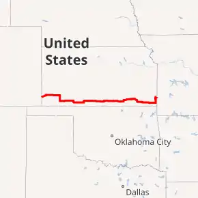
US-160 highlighted in red | ||||
| Route information | ||||
| Maintained by KDOT and the cities of Ulysses, Harper and Wellington | ||||
| Length | 489.457 mi[1] (787.705 km) | |||
| Existed | c. 1931[2]–present | |||
| Major junctions | ||||
| West end | ||||
| ||||
| East end | ||||
| Highway system | ||||
| ||||
Route description
US-160 enters Kansas just west of Saunders. It goes northeast to Johnson City, then turns east to go through Ulysses. Near Sublette, it intersects U.S. Route 83 and runs concurrently southward past its intersection with U.S. Route 56. It turns east and then runs concurrently with U.S. Route 54 between Plains and Meade. It continues east, and runs concurrently with U.S. Route 283 and U.S. Route 183. At Medicine Lodge, it intersects U.S. Route 281. It continues east and at Wellington, intersects U.S. Route 81 and then Interstate 35, on which the Kansas Turnpike is routed in the area.
East of Interstate 35, it intersects U.S. Route 77 in Winfield. It goes east from Winfield, then turns north to Burden, then goes east before going south to Elk City. It then turns east and goes through Independence after being concurrent with U.S. Route 75. It continues east, is briefly concurrent with U.S. Route 169 and then intersects U.S. Route 59 at Altamont. US-160 and US-59 then go into Oswego and separate. At Columbus, US-160 begins a concurrency with U.S. Route 69, which goes east to Crestline, then north to Frontenac, Kansas. Also at Crestline, it picks up a second concurrency with U.S. Route 400, which goes north and ends just south of Pittsburg, Kansas. After Frontenac, it turns east and enters Missouri.
The section of US-160 in Harper, from K-14 to slightly east of end of overlap with K-2 is maintained by the city.[3] The entire 2.601-mile (4.186 km) section within Wellington is maintained by the city.[4]
History
| |
|---|---|
| Location | Colorado border–Santa Fe |
| Existed | 1927[5]–c. 1931[2] |
The section of US-160 from the Colorado border to Santa Fe was established in 1927 as K-46. The section from K-22, now US-83, south of Sublette east to Pittsburg was established in 1927 as K-12.[5] US-160 was extended into Kansas between 1930 and 1931, which resulted in K-46 being decommissioned and K-12 being truncated to US-54 north of Liberal.[2]
East of Coldwater, US-160 originally turned north to Wilmore then curved southwest and traveled through Sun City and Lake City to its current alignment west of Medicine City. Then between 1941 and 1944, a new alignment was built to travel directly east–west from Coldwater to Medicine City.[6][7] East of Independence, US-160 originally followed US-169 north to K-37 then east to US-400, which it followed to its current alignment south of Pittsburg. Then in a December 9, 1998 resolution, US-160 was realigned over K-96 from US-169 east to US-69 Alternate then turned north toward Pittsburg.[8][9][10]
Between 1951 and 1952, the alignment was shifted south between the Colorado border and Johnson.
Major intersections
| County | Location | mi[1] | km | Destinations | Notes |
|---|---|---|---|---|---|
| Stanton | | 0.000 | 0.000 | Continuation into Colorado | |
| | 16.816 | 27.063 | Western end of K-27 overlap | ||
| | 17.823 | 28.683 | Eastern end of K-27 overlap | ||
| Grant | Ulysses | 39.700 | 63.891 | ||
| | 53.880 | 86.711 | Northern terminus of K-190 | ||
| Haskell | | 66.931 | 107.715 | Western end of US-83 overlap; western terminus of K-144 | |
| | 72.950 | 117.402 | |||
| Seward | | 79.944 | 128.657 | Southern terminus of K-190 | |
| | 86.967 | 139.960 | Eastern end of US-83 overlap | ||
| Meade | Plains | 103.660 | 166.825 | Western end of US-54 overlap | |
| Meade | 116.556 | 187.579 | |||
| 117.882 | 189.713 | Eastern end of US-54 overlap | |||
| Clark | | 135.261 | 217.681 | Western end of US-283 overlap | |
| | 141.842 | 228.273 | Eastern end of US-283 overlap | ||
| | 160.031 | 257.545 | Western end of US-183 overlap; southern terminus of K-34 | ||
| Comanche | | 177.978 | 286.428 | Northern terminus of K-1 | |
| | 183.928 | 296.003 | Eastern end of US-183 overlap | ||
| Barber | | 224.293 | 360.965 | Western end of US-281 overlap | |
| Medicine Lodge | 224.920 | 361.974 | Eastern end of US-281 overlap | ||
| Harper | | 256.218 | 412.343 | Western end of K-2 overlap | |
| | 259.233 | 417.195 | Southern terminus of K-14 | ||
| | 260.345 | 418.985 | Eastern end of K-2 overlap | ||
| Sumner | | 279.725 | 450.174 | Milan Road – Milan | Northern terminus of former K-205 |
| | 281.711 | 453.370 | Western end of K-49 overlap | ||
| | 284.644 | 458.090 | Eastern end of K-49 overlap | ||
| | 286.626 | 461.280 | Mayfield Road – Mayfield | Northern terminus of former K-271 | |
| Wellington | 294.838 | 474.496 | West end of US-81 overlap | ||
| 295.440 | 475.465 | North Washington Avenue – Business District | Former routing of US-81 | ||
| 295.703 | 475.888 | East end of US-81 overlap; roundabout | |||
| | 298.713 | 480.732 | I-35/Kansas Turnpike exit 19 | ||
| Cowley | Winfield | 318.339 | 512.317 | Western end of K-15 overlap | |
| | 320.951 | 516.521 | |||
| | 330.892 | 532.519 | Eastern end of K-15 overlap | ||
| Elk | | 364.045 | 585.874 | Western end of K-99 overlap | |
| | 364.609 | 586.781 | Eastern end of K-99 overlap | ||
| Montgomery | | 402.003 | 646.961 | Western end of US-75 overlap | |
| Independence | 405.023 | 651.821 | Eastern end of US-75 overlap | ||
| | 411.963 | 662.990 | Western end of US-169 overlap | ||
| | 412.966 | 664.604 | Eastern end of US-169 overlap | ||
| Labette | | 423.656 | 681.808 | Hickory Street – Mound Valley | Southern terminus of former K-222 |
| | 426.487 | 686.364 | Northern terminus of K-101 | ||
| | 431.485 | 694.408 | Western end of US-59 overlap | ||
| Oswego | 441.343 | 710.273 | Eastern end of US-59 overlap | ||
| Cherokee | | 456.821 | 735.182 | Western end of US-69 overlap | |
| | 463.842 | 746.481 | Western end of US-400 overlap; northern terminus of US-69 Alternate | ||
| | 472.960 | 761.155 | Eastern terminus of K-103 | ||
| Cherokee–Crawford county line | | 474.927 | 764.321 | Eastern end of US-400 overlap; western terminus of K-171 | |
| Crawford | Pittsburg | 477.953 | 769.191 | Southern terminus of US-69 Business | |
| 480.278 | 772.933 | ||||
| 482.607 | 776.681 | Northern terminus of US-69 Business | |||
| Frontenac | 484.617 | 779.915 | Eastern end of US-69 overlap | ||
| | 489.457 | 787.705 | Continuation into Missouri | ||
1.000 mi = 1.609 km; 1.000 km = 0.621 mi
| |||||
References
- Staff (2016). "Pavement Management Information System". Kansas Department of Transportation. Retrieved April 21, 2017.
- Rand McNally and Company (1931). "Kansas" (Map). Clason's Road Map of Kansas. 1:2,000,000. Denver: Clason Map Company. p. 87 – via Rumsey Collection.
- Kansas Department of Transportation (July 10, 2006). "Resolution Designating City Connecting Links in State Highway System". Topeka: Kansas Department of Transportation. Retrieved September 9, 2020.
- Kansas Department of Transportation (January 9, 2008). "Resolution Designating City Connecting Links in State Highway System". Topeka: Kansas Department of Transportation. Retrieved September 10, 2020.
- Rand McNally and Company (1927). "Kansas" (Map). Rand McNally Auto Road Atlas of the United States and Ontario, Quebec, and the Maritime Provinces of Canada, with a Brief Description of the National Parks and Monuments. 1:1,600,000. Chicago: Rand McNally and Company. pp. 54–55. OCLC 2078375. Retrieved July 27, 2020 – via Rumsey Collection.
- State Highway Commission of Kansas (1941). Kansas State Highway System (PDF) (Map). Scale not given. Topeka: State Highway Commission of Kansas. Retrieved July 28, 2020.
- State Farm Insurance Companies Travel Bureau (1944). "Kansas" (Map). State Farm Road map: Kansas. 1:1,235,520. Chicago: Rand McNally and Company. Retrieved July 28, 2020 – via Rumsey Collection.
- Kansas Department of Transportation (December 3, 1998). "Rural Resolution to remove K-96 from US-400/US-75/US-160 and to redesignate K-96 to US-160 in Montgomery County". Topeka: Kansas Department of Transportation. Retrieved July 28, 2020.
- Kansas Department of Transportation (December 3, 1998). "Rural Resolution to redesignate K-96 to US-160 and remove US-160 from US-400 in Labette County". Topeka: Kansas Department of Transportation. Retrieved July 28, 2020.
- Kansas Department of Transportation (December 3, 1998). "Rural Resolution to redesignate K-96 to US-160 and remove US-160 from US-400 in Cherokee County". Topeka: Kansas Department of Transportation. Retrieved July 28, 2020.
