K-204 (Kansas highway)
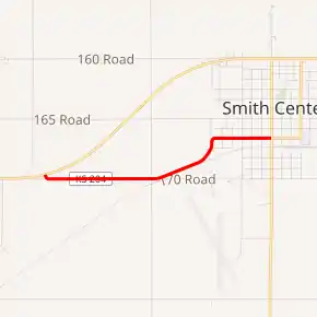
K-204 is a short 2.116-mile-long (3.405 km) east–west state highway in the U.S. state of Kansas. K-204's western terminus is at U.S. Route 36 (US-36) west of the City of Smith Center and the eastern terminus is at US-281 in the City of Smith Center.[3] The route was first designated a state highway on August 13, 1958.[2]
| ||||
|---|---|---|---|---|
K-204 highlighted in red | ||||
| Route information | ||||
| Maintained by KDOT | ||||
| Length | 2.116 mi[1] (3.405 km) | |||
| Existed | August 13, 1958[2]–present | |||
| Major junctions | ||||
| West end | ||||
| East end | ||||
| Location | ||||
| Counties | Smith | |||
| Highway system | ||||
| ||||

Route description
K-204 begins at an intersection with US-56 west of Smith Center. It starts traveling east for roughly 0.9 miles (1.4 km) and reaches an intersection with O Road. At this point it turns slightly northeast and begins to parallel the MSPA/KYLE Railroad. The next roughly 0.5 miles (0.80 km) it slowly curves north, entering Smith Center along the way. Shortly after entering Smith Center it curves back to the east again. It continues east another roughly 0.5 miles (0.80 km) and reaches US-281.[3]
The Kansas Department of Transportation (KDOT) tracks the traffic levels on its highways, and in 2018, they determined that on average the traffic was 475 vehicles near the western terminus.[4] K-204 is not included in the National Highway System.[5] The National Highway System is a system of highways important to the nation's defense, economy, and mobility. K-204 does connect to the National Highway System at its western terminus at US-56 and at its eastern terminus at US-160.[6] The entire route is paved with partial design bituminous pavement.[7][8]
History
Early roads
Before state highways were numbered in Kansas there were auto trails, which were an informal network of marked routes that existed in the United States and Canada in the early part of the 20th century. The western terminus of K-204 (US-36) was part of the Pikes Peak Ocean to Ocean Highway. The eastern terminus (US-281) was part of the Sunflower Trail.[9]
Establishment and realignments
K-204 was first designated a state highway on August 13, 1958, as a 1.614 miles (2.597 km) spur from US-56 to Smith Center.[2] It followed an old alignment of US-56 that had been decommissioned on October 10, 1951.[10] K-204 was extended furthur east to end at US-281 by 1968.[11]
Major intersections
The entire route is in Smith County.
| Location | mi[1] | km | Destinations | Notes | |
|---|---|---|---|---|---|
| Center Township | 0.000 | 0.000 | Western terminus | ||
| Smith Center | 2.116 | 3.405 | Eastern terminus | ||
| 1.000 mi = 1.609 km; 1.000 km = 0.621 mi | |||||
References
- Staff (2016). "Pavement Management Information System". Kansas Department of Transportation. Retrieved April 16, 2017.
- State Highway Commission of Kansas (August 13, 1958). "Resolution for Addition to State Highway System in Smith County". Topeka: State Highway Commission of Kansas. Retrieved August 26, 2019.
- Bureau of Transportation Planning (2011). Smith County (PDF) (Map). Scale not given. General Highway Map. Topeka: Kansas Department of Transportation. Retrieved August 23, 2019.
- Bureau of Transportation Planning (2018). Traffic Flow Map Kansas State Highway System (PDF) (Map). [c. 1:1,584,000]. Topeka: Kansas Department of Transportation. Retrieved July 29, 2019.
- Federal Highway Administration (May 8, 2019). National Highway System: Kansas (PDF) (Map). [c. 1:3,900,000]. Federal Highway Administration. Retrieved July 29, 2019.
- Natzke, Stefan; Neathery, Mike; Adderly, Kevin (September 26, 2012). "What is the National Highway System?". National Highway System. Federal Highway Administration. Retrieved July 29, 2019.
- Staff (2012-07-19). "Pavement Management Information System Query". Kansas Department of Transportation. Retrieved 2013-01-22.
- Staff (2012-05-09). "Pavement Management Information System Glossary". Kansas Department of Transportation. Missing or empty
|url=(help) - Rand McNally and Company (1924). "Kansas" (Map). AutoTrails Map, Southern Nebraska, Eastern Colorado, Kansas, Northeastern New Mexico, Northern Oklahoma. 1:1,600,000. Chicago: Rand McNally and Company. OCLC 2078375. Retrieved June 15, 2020 – via Rumsey Collection.
- State Highway Commission of Kansas (October 10, 1951). "Resolution for Relocation and Redesignation of Road in Smith County". Topeka: State Highway Commission of Kansas. Retrieved August 26, 2019.
- Bureau of Transportation Planning (1968). Smith County (PDF) (Map). Scale not given. General Highway Map. Topeka: State Highway Commission of Kansas. Retrieved August 23, 2019.