Kabulasoke
Kabulasoke is a town in Gomba District in the Central Region of Uganda.
Kabulasoke | |
|---|---|
 Kabulasoke Solar Power Station | |
 Kabulasoke Map of Uganda showing location of Kabulasoke | |
| Coordinates: 00°09′27″N 31°48′42″E | |
| Country | |
| Region | Central Region |
| Districts | Gomba District |
| Government | |
| • Member of Parliament | Mariam Najjemba |
| Elevation | 1,222 m (4,009 ft) |
| Time zone | UTC+3 (EAT) |
Location
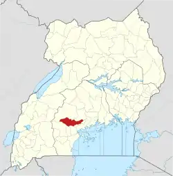
The town is in Kabulasoke Sub-county, being one of the nine parishes in that administrative unit.[1] Kabulasoke is approximately 15 kilometres (9 mi), by road, west of Kanoni, the location of the district headquarters.[2] This is approximately 22 kilometres (14 mi) southeast of Maddu, the nearest large town.[3]
Kabulasoke is approximately 112 kilometres (70 mi), by road, southwest of Kampala, the capital and largest city of Uganda.[4] The coordinates of Kabulasoke are 0°09'25.0"N, 31°48'42.0"E (Latitude:0.156944; Longitude:31.811667).[5] The average elevation of the town is about 1,222 metres (4,009 ft) above mean sea level.[6]
Overview
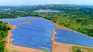
In April 2015, Xsabo Power Limited applied for a license to generate 20 megawatts of solar power from the ten proposed Kabulasoke Solar Power Station, located in Namulasa Village, Butiti Parish, Kabulasoke Sub-County, Gomba District.[7] Had the license been granted in time, the power station was expected to come online in December 2015.[8][9]
The 135 kilometres (84 mi) Mpigi–Kabulasoke–Maddu–Sembabule Road passes through town.[10] The town is also the location of Kabulasoke CORE Primary Teachers' College.[11]
References
- LCMT (21 August 2015). "Parishes in Kabulasoke Subcounty, Gomba District, Uganda". Land Conflict Mapping Tool (LCMT). Retrieved 21 August 2015.
- Google (2 November 2020). "Road Distance Between Kanoni, Gomba, And Kabulasoke, Gomba, Uganda" (Map). Google Maps. Google. Retrieved 2 November 2020.
- Google (2 November 2020). "Road Distance Between Maddu, Gomba And Kanoni, Gomba, Uganda" (Map). Google Maps. Google. Retrieved 2 November 2020.
- Google (2 November 2020). "Road Distance Between Kampala And Kabulasoke" (Map). Google Maps. Google. Retrieved 2 November 2020.
- Google (2 November 2020). "Location of Kabulasoke, Gomba, Uganda" (Map). Google Maps. Google. Retrieved 2 November 2020.
- Geoview (21 August 2015). "Kabulasoke, Gomba District, Central Uganda: Estimated Terrain Elevation Above Sea Level". Geoview.info. Retrieved 21 August 2015.
- ERA (10 April 2015). "Application for a License for the Establishment of a 20 MW Solar Photo Voltaic Power Project in Gomba District and 20 MW Wind Power Project in Tororo District". Electricity Regulatory Authority (ERA). Retrieved 21 August 2015.
- KFMU Reporter (22 May 2015). "20 Mega Watt Solar Power Park to be commissioned in Kabulasoke". Kfm.co.ug (KFMU). Retrieved 21 August 2015.
- Alobo, David (February 2013). "Tentative Layout Plan - Pilot Solar Power Park, Kabulasoke, Uganda" (PDF). Kampala: Electricity Regulatory Authority. Retrieved 28 January 2016.
- Google (21 August 2015). "Location of Mpigi–Kabulasoke–Maddu–Sembabule Road At Google Maps" (Map). Google Maps. Google. Retrieved 21 August 2015.
- UMC (2 June 2014). "President Urges Leaders to Diagnose People's Challenges". Mediacentre.go.ug (UMC). Retrieved 21 August 2015.
External links
Capital: Kanoni | ||
| Towns and villages |
|  |
| Economy |
| |
| Energy | ||
| Health |
| |
| Transport | ||
| Notable people | ||