Kakhovka Reservoir
The Kakhovka Reservoir (Ukrainian: Каховське водосховище, Kakhovs’ke vodoskhovyshche) is a water reservoir located on the Dnieper River.
| Kakhovka Reservoir | |
|---|---|
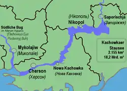 Map of the Kakhovka Reservoir | |
 Kakhovka Reservoir | |
| Location | Kherson, Zaporizhzhia, and the Dnipropetrovsk Oblasts |
| Coordinates | 47°28′N 34°10′E |
| Type | Hydroelectric reservoir |
| Primary inflows | Dnieper River |
| Primary outflows | Dnieper River |
| Basin countries | Belarus, Ukraine |
| Max. length | 240 km (150 mi) |
| Max. width | 23 km (14 mi) |
| Surface area | 2,155 km2 (832 sq mi) |
| Average depth | 8.4 m (28 ft) |
| Max. depth | 26 m (85 ft) |
| Water volume | 18.2 km3 (14,800,000 acre⋅ft) |
| Surface elevation | 44 m (144 ft) |
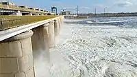
The reservoir was created in 1956 when the Kakhovka Hydroelectric Power Plant was built.
Geography
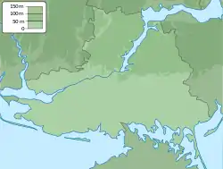
It covers a total surface area of 2,155 square kilometres in the territories of the Kherson, Zaporizhzhia, and the Dnipropetrovsk Oblasts of Ukraine.[1]
The reservoir is 240 km long, up to 23 km wide, and has an average depth of 8.4 meters (with depth varying from 3 to 26 m). The total water volume is 18.2 km³. It is mainly used to supply hydroelectric stations, the Krasnoznamianka Irrigation System and the Kakhovka Irrigation System, industrial plants, freshwater fish farms, the North Crimean Canal and the Dnieper–Kryvyi Rih Canal. With its creation, it has created a deep-water route, allowing deep-sea ships to sail up the Dnieper.[2]
See also
- Dams on the Dnieper River
- Reservoirs in Ukraine
Gallery

| Tributaries1 |  | |
|---|---|---|
| Reservoirs | ||
| Hydroelectric stations | ||
| Canals |
| |
| Cities | ||
| Crossings | ||
| ||
References
- "КАХОВСЬКЕ ВОДОСХОВИЩЕ". leksika.com.ua. Retrieved 2020-06-12.
- "Каховське водосховище | Енциклопедія Сучасної України". esu.com.ua. Retrieved 2020-06-12.