Kanas River
The Kanas River (Chinese: 喀納斯河) is located in Altay Prefecture, Xinjiang Uygur Autonomous Region, China. It starts from Khüiten Peak, runs at the foot of the Altai Mountains, and, via the Kanas Lake, flows into the Hemu River.
Overview
The Kanas River is the northernmost river of Xinjiang Uygur Autonomous Region. It starts from the southwestern foot of the Tavan Bogd massif, on the border of the three countries China, Mongolia and Russia, and runs along the foot of the Altai Mountains. It then that flows into the Kanas Lake as the Upper Kanas River, and flows out of the Kanas Lake as the Lower Kanas River.
Upper Kanas River
The Kanas River begins at the southwest foot of Yuyi Mountain of the Tawan Bogd massif, runs at the foot of Altai Mountains, collecting water from other rivers, and flows into the northern end of the Kanas Lake.
Lower Kanas River
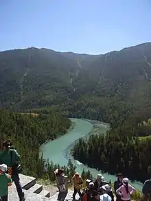
The river that flows out from the southern end of the Kanas Lake is also called the Kanas River. It runs down through the scenic spots, such as Shenxian Bay (神仙湾), Moon Bay(月亮湾) , and Wolong Bay (臥龍湾),[1][2] and flows into the Hemu River (禾木河). The Hemu flows into the Burqin River (布尔津河), then further runs down into the Irtysh and Ob Rivers, and finally enters the Arctic Ocean.
See also
- Kanas Lake
- Hemu River川 (禾木河)
References
- 北疆之旅(九)〜喀納斯湖、月亮灣、臥龍灣、與觀魚亭 in Chinese with a map of the area
- Kanas River (Burqin County)
External links
- Photos of Kanas River
- Photos of Kanas River in Chinese
