Kankaanpää
Kankaanpää (Finnish pronunciation: [ˈkɑŋkɑːmˌpæː]) is a town and municipality of Finland. Kankaanpää was founded in 1865, became a township in 1967 and finally a town in 1972. It is located in the crossroads of Hämeenkangas and Pohjankangas ridges. It belongs to the region of Satakunta. Kankaanpää has a population of about 11,200 inhabitants.[2] Pori is located 53 kilometres (33 mi) southwest of Kankaanpää.
Kankaanpää | |
|---|---|
Town | |
| Kankaanpään kaupunki Kankaanpää stad | |
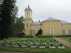 Military cemetery at church in Kankaanpää | |
 Coat of arms | |
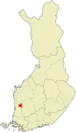 Location of Kankaanpää in Finland | |
| Coordinates: 61°48′N 022°24′E | |
| Country | |
| Region | Satakunta |
| Sub-region | Northern Satakunta sub-region |
| Charter | 1865 |
| Market town | 1967 |
| Town privileges | 1972 |
| Government | |
| • Town manager | Mika Hatanpää |
| Area (2018-01-01)[1] | |
| • Total | 704.73 km2 (272.10 sq mi) |
| • Land | 689.57 km2 (266.24 sq mi) |
| • Water | 15.37 km2 (5.93 sq mi) |
| Area rank | 122nd largest in Finland |
| Population (2020-07-31)[2] | |
| • Total | 11,234 |
| • Rank | 88th largest in Finland |
| • Density | 16.29/km2 (42.2/sq mi) |
| Population by native language | |
| • Finnish | 98.9% (official) |
| • Swedish | 0.1% |
| • Others | 1% |
| Population by age | |
| • 0 to 14 | 15.5% |
| • 15 to 64 | 66.1% |
| • 65 or older | 18.4% |
| Time zone | UTC+02:00 (EET) |
| • Summer (DST) | UTC+03:00 (EEST) |
| Municipal tax rate[5] | 20% |
| Climate | Dfc |
| Website | www.kankaanpaa.fi |
Honkajoki municipality was merged with Kankaanpää on January 1, 2021.[6]
History
First signs of humanity in the area are from the stone age and during the 16th century people started to settle in Kankaanpää area. Oldest houses that area found from the documents of Sweden-Finland are from the 1560 decade. There were three houses in Kankaanpää then: Honko, Oukari and Päivike.[7]
The oldest passage in the province was from Hämeenkyrö through the ridges to Kauhajoki. In the 17th century it was the most important road between southern Finland and Ostrobothnia. The king of Sweden visited Kankaanpää twice. Gustavus Adolphus travelled from Ilmajoki to Hämeenlinna through Kankaanpää in 1614 and Adolf Fredrik had a rest in Kuninkaanlähde spring to water his horses and to eat in 1752. The spring was named after this event.
The church of Kankaanpää has been built in 1839. Architect of the church was C. L. Engel.
Climate
Based on the village of Niinisalo about 5.7 km northeast of the site the climate is a continental subtarctic frontier (Köppen: Dfc) considering that the warmest fourth month is around 9 °C, which puts Kankaanpää in a humid continental climate (Dfb) being closer to Helsinki than Oulu, it also means that summer is more consistent and warm but winters are still cold.[8] The municipality is considered one of the rainiest of Finland with 571 mm only during a growing season in 1995. Being the growing season from early May to October 10.[9]
| Climate data for Kankaanpää (Niinisalo), elevation: 136 m or 446 ft, 1961-1990 normals and extremes | |||||||||||||
|---|---|---|---|---|---|---|---|---|---|---|---|---|---|
| Month | Jan | Feb | Mar | Apr | May | Jun | Jul | Aug | Sep | Oct | Nov | Dec | Year |
| Record high °C (°F) | 7.0 (44.6) |
8.5 (47.3) |
13.5 (56.3) |
21.2 (70.2) |
28.4 (83.1) |
32.5 (90.5) |
30.4 (86.7) |
31.2 (88.2) |
27.7 (81.9) |
16.3 (61.3) |
10.2 (50.4) |
7.0 (44.6) |
32.5 (90.5) |
| Average high °C (°F) | −5.1 (22.8) |
−4.6 (23.7) |
0.2 (32.4) |
6.3 (43.3) |
14.7 (58.5) |
19.7 (67.5) |
21.1 (70.0) |
18.8 (65.8) |
12.8 (55.0) |
7.0 (44.6) |
1.0 (33.8) |
−2.9 (26.8) |
7.4 (45.3) |
| Daily mean °C (°F) | −8.0 (17.6) |
−7.8 (18.0) |
−3.7 (25.3) |
1.9 (35.4) |
9.0 (48.2) |
14.0 (57.2) |
15.7 (60.3) |
13.8 (56.8) |
8.8 (47.8) |
4.0 (39.2) |
−1.3 (29.7) |
−5.6 (21.9) |
3.4 (38.1) |
| Average low °C (°F) | −11.3 (11.7) |
−11.1 (12.0) |
−7.4 (18.7) |
−2.2 (28.0) |
3.4 (38.1) |
8.2 (46.8) |
10.5 (50.9) |
9.4 (48.9) |
5.3 (41.5) |
1.2 (34.2) |
−3.7 (25.3) |
−8.7 (16.3) |
−0.5 (31.0) |
| Record low °C (°F) | −34.9 (−30.8) |
−35.7 (−32.3) |
−25.4 (−13.7) |
−14.3 (6.3) |
−7.0 (19.4) |
−3.0 (26.6) |
2.0 (35.6) |
0.2 (32.4) |
−5.4 (22.3) |
−14.7 (5.5) |
−23.8 (−10.8) |
−33.0 (−27.4) |
−35.7 (−32.3) |
| Average precipitation mm (inches) | 42.0 (1.65) |
29.0 (1.14) |
33.0 (1.30) |
38.0 (1.50) |
37.0 (1.46) |
53.0 (2.09) |
71.0 (2.80) |
80.0 (3.15) |
73.0 (2.87) |
54.0 (2.13) |
59.0 (2.32) |
47.0 (1.85) |
616 (24.26) |
| Average precipitation days (≥ 1.0 mm) | 10.0 | 8.0 | 9.0 | 8.0 | 7.0 | 8.0 | 11.0 | 11.0 | 11.0 | 11.0 | 11.0 | 11.0 | 116 |
| Source: NOAA[10] | |||||||||||||
Politics
Results of the 2011 Finnish parliamentary election in Kankaanpää:
- True Finns 37.2%
- Centre Party 25.5%
- National Coalition Party 11.8%
- Social Democratic Party 10.6%
- Left Alliance 7.7%
- Christian Democrats 4.4%
- Green League 2.4%
Education
Kankaanpää offers basic education with 6 elementary schools and a secondary school. There is also a trade school and a polytechnic school which will be abolished in near future. The Artillery School in the Artillery Brigade provides university-level education for all future career artillery officers.
Culture
Kankaanpää town museum is presenting the life in Kankaanpää during the last 100 years.
Military
It is located near the Pohjankangas Training Area, which is capable of housing main battle tanks used by the United States Marine Corps.[11]
International relations
Twin towns — sister cities
Kankaanpää is twinned with:
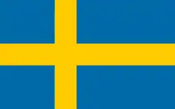 Bollnäs, Sweden
 Flekkefjord, Norway
 Gagra, Georgia
 Misburg, Germany
 Morsø Municipality, Denmark
People born in Kankaanpää
- Cristal Snow, musician and drag queen
- Toni Vilander (1980–), racing driver
References
- "Area of Finnish Municipalities 1.1.2018" (PDF). National Land Survey of Finland. Retrieved 30 January 2018.
- "Suomen virallinen tilasto (SVT): Väestön ennakkotilasto [verkkojulkaisu]. Heinäkuu 2020" (in Finnish). Statistics Finland. Retrieved 13 September 2020.
- "Population according to language and the number of foreigners and land area km2 by area as of 31 December 2008". Statistics Finland's PX-Web databases. Statistics Finland. Retrieved 29 March 2009.
- "Population according to age and gender by area as of 31 December 2008". Statistics Finland's PX-Web databases. Statistics Finland. Retrieved 28 April 2009.
- "List of municipal and parish tax rates in 2011". Tax Administration of Finland. 29 November 2010. Retrieved 13 March 2011.
- Laakso, Antti (May 15, 2020). "Honkajoki liittyy Kankaanpäähän vuodenvaihteessa – valtuustot hyväksyivät ainoan Suomessa vireillä olevan kuntaliitoksen". YLE News (in Finnish). YLE. Retrieved January 2, 2021.
- "RKY ι Museovirasto". www.rky.fi. Retrieved 2019-09-06.
- "Niinisalo, Kankaanpää, Satakunta Climate Niinisalo, Kankaanpää, Satakunta Temperatures Niinisalo, Kankaanpää, Satakunta Weather Averages". www.kankaanpaa.climatemps.com. Retrieved 2019-03-03.
- Ilmasto-opas.fi. "Suomen muuttuva ilmasto - Ilmasto-opas.fi". Ilmasto-opas (in Finnish). Retrieved 2019-03-03.
- "Kankaanpää (02942) - WMO Weather Station". NOAA. Retrieved March 3, 2019.
- Snow, Shawn (May 22, 2018). "The Corps moved tanks from secret caves in Norway to Finland. Here's why". Marine Corps Times.
But the Corps pulled out all the stops by moving its main battle tank from a series of secret cave complexes in Norway — a Cold War era storage program designed to rapidly equip Marines for a fight with Russia — to Pojankangas Training Area near Kankaanpaa, Finland for the exercise.
External links
| Wikimedia Commons has media related to Kankaanpää. |
| Municipalities |  | |
|---|---|---|
| Former municipalities | ||
| Authority control |
|---|