Kap-Kig-Iwan Provincial Park
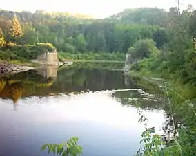
Kap-Kig-Iwan Provincial Park is a protected area in the incorporated townships of Charlton and Dack[2] and Evanturel[3] in Timiskaming District in Northeastern Ontario, Canada.[1] Established in 1957, the 325-hectare (803-acre) park[4] is located along the Englehart River, off Ontario Highway 11 about 2 kilometres (1.2 mi) south of the town of Englehart. It is classified as a Natural Environment park.[5] Kap-Kig-Iwan is a provincial park of Ontario.
| Kap-Kig-Iwan Provincial Park | |
|---|---|
IUCN category IV (habitat/species management area) | |
 | |
 Location in Ontario | |
| Location | Timiskaming District, Ontario, Canada |
| Nearest city | Englehart |
| Coordinates | 47°47′46″N 79°53′13″W[1] |
| Area | 325 hectares (803 acres) |
| Established | 1957 |
| Governing body | Ontario Parks |
| www | |
Kap-Kig-Iwan has both electric and non-electric campsites. The park is used by cross-country skiers during the winter months. Many of the trails double as ski trails.[6]
References
- "Kap-Kig-Iwan Provincial Park". Geographical Names Data Base. Natural Resources Canada. Retrieved 2014-05-15.
- "Dack" (PDF). Geology Ontario - Historic Claim Maps. Ontario Ministry of Northern Development, Mines and Forestry. Archived from the original (PDF) on 2014-05-17. Retrieved 2014-05-15.
- "Evanturel" (PDF). Geology Ontario - Historic Claim Maps. Ontario Ministry of Northern Development, Mines and Forestry. Archived from the original (PDF) on 2014-05-17. Retrieved 2014-05-15.
- "Kap-Kig-Iwan Park". Town of Englehart. 2013. Retrieved 2014-05-15.
- "Kap-Kig-Iwan Provincial Park Management Plan" (PDF). Ontario Ministry of Natural Resources. 1984. Retrieved 2014-05-15.
- "Kap-Kig-Iwan Provincial Park". Ontario Parks. 2020-10-06. Retrieved 2020-10-06.
Other map sources:
- Map 15 (PDF) (Map). Official road map of Ontario. Ministry of Transportation of Ontario.
- Restructured municipalities - Ontario map #3 (Map). Restructuring Maps of Ontario. Ontario Ministry of Municipal Affairs and Housing. 2006. Retrieved 2014-05-15.
External links
This article is issued from Wikipedia. The text is licensed under Creative Commons - Attribution - Sharealike. Additional terms may apply for the media files.