Kara (river)
The Kara (Russian: Ка́ра) is a river draining to the Arctic Kara Sea in Northern Siberia.[1] It flows through the Pay-Khoy Mountains in the Polar Ural region, and forms parts of the borders between the Yamalo-Nenets Autonomous Okrug, the Nenets Autonomous Okrug and the Komi Republic.
| Kara | |
|---|---|
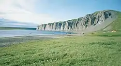 From the lower reaches of Kara | |
| Native name | Russian: Ка́ра |
| Location | |
| Country | Russia |
| Physical characteristics | |
| Source | Confluence of the rivers Malaya and Bolshaya Kara |
| Mouth | Baydaratskaya Bay (Kara Sea) |
• coordinates | 69°09′59″N 64°47′11″E |
| Length | 257 km (160 mi) |
| Basin size | 13,400 km2 (5,200 sq mi) |
The length of the river, from the confluence of the Malaya and Bolshaya Kara to the mouth in the Baydaratskaya Bay is 257 kilometres (160 mi). Its drainage basin area is 13,400 square kilometres (5,200 sq mi).[2] The settlement of Ust-Kara is near the river mouth. The name of the river is derived from Nenets word meaning "hummocked ice".[3]
References
- Кара (река), Great Soviet Encyclopedia
- Река Кара in the State Water Register of Russia (Russian)
- V.Yu. Vize, Karskoye more // Morya Sovetskoy Arktiki: Ocherki po istorii issledovaniya (Leningrad, 1939) — pp. 180—217
This article is issued from Wikipedia. The text is licensed under Creative Commons - Attribution - Sharealike. Additional terms may apply for the media files.
