Karitane
The small town of Karitane is located within the limits of the city of Dunedin in New Zealand, 35 kilometres to the north of the city centre.
Karitane | |
|---|---|
Town | |
 Karitane Location of Karitane within New Zealand | |
| Coordinates: 45°38′20″S 170°39′20″E | |
| Country | New Zealand |
| Region | Otago |
| Territorial authority | Dunedin City Council |
| Population (2013 census)[1] | |
| • Urban Area | 360 |
| Time zone | UTC+12 (NZST) |
| • Summer (DST) | UTC+13 (NZDT) |
| Postcode | 9471 |
| Local iwi | Ngāi Tahu |
Set in rolling country near the mouth of the Waikouaiti River, the town is a popular holiday retreat for Dunedinites.
History
Early history
The site of the present settlement of Karitane includes that of the pre-European Māori kaik, or undefended village. Giant moas were likely to be hunted in the area.[2]
It encompasses Huriawa on the adjacent peninsula, a pā or fortified village, recalled in oral tradition for sieges in the late 17th or early 18th centuries. It was also the site of the whaling station set up by Long, Wright and Richards in 1837. That was known as Waikouaiti, but the name later became transferred to the present township of that name established by Johnny Jones as a farming settlement in 1840, on the north side of the estuary.
Modern history
In 1838 Jones acquired the Karitane whaling station, primarily targeting southern rights and humpbacks, resulting in severe depletion of local populations for these species. After sending pioneers to start his farming settlement he sent a Wesleyan missionary to join them in May 1840. Rev. James Watkin established the first mission station in the South Island.[3] The first Christian service in the South Island took place in Karitane on 17 May, 1840. Watkin set up his mission station at Karitane. He was living there with his wife and children in a purpose-built house by late 1842. In 1867 George O'Brien painted a memorable view looking north from the Karitane waterfront, now in the Otago Settlers Museum, Dunedin.
Karitane Nurses are also mentioned in the Australian Television Miniseries Paper Giants: The Birth of Cleo, suggesting their influence had spread to Australia by the 1970s.
In early February 2021, high levels of lead (40 times the acceptable level of 0.01mg/L) were detected in Karitane and nearby Waikouaiti's drinking water. The high levels of lead were first detected on 18 December 2020 but the alert was emailed to a Dunedin City Council staff member who was on holiday.[4][5] In response, Director-General of Health Ashley Bloomfield offered free blood tests to Karitane and Waikouaiti residents. The Dunedin City Council also dispatched water tanks and staff to assist and reassure local residents.[5] Prime Minister Jacinda Ardern described the lead levels in Karitane and Waikouaiti as "unacceptable."[6] On 9 February, the City Council distributed free fruits and vegetables to residents of Karitane, Waikouaiti, and Hawksbury due to concerns about eating crops irrigated with the contaminated water.[7]
Association with Truby King
The name Karitane is often associated with pioneering paediatrician and psychiatrist Sir Truby King, founder of the Plunket Society. The name is echoed in many New Zealand child-related services and products:
- Plunket set up a string of neonatal care institutions known throughout the country as Karitane Hospitals, starting here in Truby King's house, Kingscliff[8][9]
- A type of infant formula, Karicare, now made by Nutricia, as well as earlier brands Karilac and Kariol made by the Karitane Products Society are named after the town[9][10]
- Karitane Nurse (historically) a type of nurse in New Zealand specialising in infant care[9]
- Community Karitane, a type of community worker in New Zealand advising on parenting issues such as breastfeeding, nutrition, sleep and behaviour.[11]
- Karitane yellow, an informal name for a (baby-excrement-coloured) unpleasant shade of yellow[12]
Truby King also worked at nearby Seacliff Lunatic Asylum.
Culture

Huirapa Marae, also known as Puketeraki Marae, is located in Karitāne. It is a marae (meeting ground) of Ngāi Tahu, including the Kāti Huirapa Rūnanga Ki Puketeraki branch, and includes the Karitāne wharenui (meeting house).[13][14]
Close to the settlement is the site of Huriawa Pā, which was a major pā (fortification) in pre-European New Zealand. It was set in a strong position on a rocky promontory above the coast.
Gallery
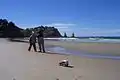 Karitane Beach
 Kayakers and a Hooker's sea lion resting in Karitane Harbor
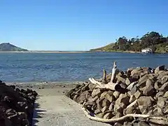
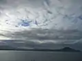 View of the Karitane harbour and seaside on a dark and cloudy day
References
| Wikimedia Commons has media related to Karitane. |
- 2013 Census QuickStats about a place : Karitane
- Teviotdale D. (1932). "The material culture of the Moa-hunters in Murihiku. – 2. EVIDENCE OF ZOOLOGY". The Journal of the Polynesian Society. pp. 81–120. Retrieved 3 February 2015.
- "Watkin, James". An Encyclopaedia of New Zealand. 1966.
- "Water in two tiny NZ towns has toxic levels of lead. Locals weren't warned for a month because staffer was on holiday". The New Zealand Herald. 5 February 2021. Archived from the original on 5 February 2021. Retrieved 5 February 2021.
- Elder, Vaughan (4 February 2021). "Lead in water found at 40 times acceptable level". Otago Daily Times. Archived from the original on 5 February 2021. Retrieved 5 February 2021.
- Miller, Grant (5 February 2021). "'Unacceptable' – PM on lead levels in East Otago". Otago Daily Times. Archived from the original on 5 February 2021. Retrieved 5 February 2021.
- "Dunedin City Council providing free fruit and veg as lead water scare continues". Radio New Zealand. 9 February 2021. Archived from the original on 9 February 2021. Retrieved 9 February 2021.
- Nigel Benson, "Seacliff asylum's painful and haunting history" Otago Daily Times, Dunedin 27 January 2007
- Jim Sullivan I was a Plunket baby 2007 Random House New Zealand
- "Nutricia Karicare". nutriciababy.co.nz. Nutricia. Archived from the original on 26 June 2007. Retrieved 17 July 2007.
- "Careers Karitene". careers.govt.nz. Career Services, New Zealand Government.
- A Dictionary of Maori words in New Zealand English, Oxford University Press, Melbourne 2005
- "Te Kāhui Māngai directory". tkm.govt.nz. Te Puni Kōkiri.
- "Māori Maps". maorimaps.com. Te Potiki National Trust.