Karstula
Karstula is a municipality of Finland founded in 1867. It is located in the Central Finland region. The municipality has a population of 3,905 (31 July 2020)[2] and covers an area of 963.19 square kilometres (371.89 sq mi) of which 76.22 km2 (29.43 sq mi) is water.[1] The population density is 4.4 inhabitants per square kilometre (11/sq mi).
Karstula | |
|---|---|
Municipality | |
| Karstulan kunta Karstula kommun | |
 Karstula Church | |
 Coat of arms | |
 Location of Karstula in Finland | |
| Coordinates: 62°52.5′N 024°48′E | |
| Country | |
| Region | Central Finland |
| Sub-region | Saarijärvi–Viitasaari sub-region |
| Charter | 1867 |
| Government | |
| • Municipal manager | Pekka Kanervio |
| Area (2018-01-01)[1] | |
| • Total | 963.19 km2 (371.89 sq mi) |
| • Land | 887.25 km2 (342.57 sq mi) |
| • Water | 76.22 km2 (29.43 sq mi) |
| Area rank | 86th largest in Finland |
| Population (2020-07-31)[2] | |
| • Total | 3,905 |
| • Rank | 197th largest in Finland |
| • Density | 4.4/km2 (11/sq mi) |
| Population by native language | |
| • Finnish | 99.5% (official) |
| • Others | 0.5% |
| Population by age | |
| • 0 to 14 | 15.2% |
| • 15 to 64 | 60.7% |
| • 65 or older | 24.1% |
| Time zone | UTC+02:00 (EET) |
| • Summer (DST) | UTC+03:00 (EEST) |
| Municipal tax rate[5] | 18.5% |
| Website | www.karstula.fi |
Neighbouring municipalities are Kannonkoski, Kivijärvi, Kyyjärvi, Saarijärvi and Soini.
There are all together 159 lakes in Karstula. Biggest lakes are Pääjärvi, Enonjärvi and Vahanka.[6]
Architecture
- A number of historical buildings (from the beginning of the 20th century) has been preserved in the village centre, representing the original countryside buildings of the region.
- There's also a cottage designed by Alvar Aalto, though it is not listed in most Aalto's biographies.
Transport
Highway 13 between Kokkola and Lappeenranta, main road 58 between Kangasala and Kärsämäki and main road 77 between Kyyjärvi and Siilinjärvi pass through the Karstula municipality.
People
- Artturi Koskinen (1904–1981), Member of Parliament
- Jarmo Mäkinen (born 1958), actor
- Nätti-Jussi (1890–1964), legendary lumberjack
- Harri Koskinen (born 1970), designer
Culture
- The International Shooting Week
Gallery
 Pääjärvi is the largest lake in Karstula.
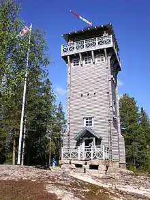 Kirkkovuori observation tower.
References
- "Area of Finnish Municipalities 1.1.2018" (PDF). National Land Survey of Finland. Retrieved 30 January 2018.
- "Suomen virallinen tilasto (SVT): Väestön ennakkotilasto [verkkojulkaisu]. Heinäkuu 2020" (in Finnish). Statistics Finland. Retrieved 13 September 2020.
- "Population according to language and the number of foreigners and land area km2 by area as of 31 December 2008". Statistics Finland's PX-Web databases. Statistics Finland. Retrieved 29 March 2009.
- "Population according to age and gender by area as of 31 December 2008". Statistics Finland's PX-Web databases. Statistics Finland. Retrieved 28 April 2009.
- "List of municipal and parish tax rates in 2011". Tax Administration of Finland. 29 November 2010. Retrieved 13 March 2011.
- "Karstula". Järviwiki. Finland's Environmental Administration. 2012. Retrieved 27 February 2012.
- "Kolme vuosikymmentä pohjoismaisia ystäväkuntasuhteita Karstulassa" (PDF) (in Finnish). Karstulan Pohjola-Norden ry. Retrieved 7 May 2012.
- "Kolme vuosikymmentä pohjoismaisia ystäväkuntasuhteita Karstulassa" (PDF) (in Finnish). Karstulan Pohjola-Norden ry. Retrieved 7 May 2012.
- "Kolme vuosikymmentä pohjoismaisia ystäväkuntasuhteita Karstulassa" (PDF) (in Finnish). Karstulan Pohjola-Norden ry. Retrieved 7 May 2012.
External links
![]() Media related to Karstula at Wikimedia Commons
Media related to Karstula at Wikimedia Commons
- Municipality of Karstula – Official website (in Finnish)
- Karstula official tourism site
- The International Shooting Week
| Municipalities | ||
|---|---|---|
| Former municipalities |
| |
| Authority control |
|---|
