Kastelberg
The Kastelberg is the fourth highest summit of the Vosges Mountains. It is located on the former border between the French regions of Alsace and Lorraine.
| Kastelberg | |
|---|---|
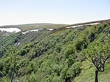
 The Kastelberg seen from the Rainkopf | |
| Highest point | |
| Elevation | 1,350 m (4,430 ft) [1] |
| Prominence | 70 m (230 ft) [2] |
| Coordinates | 48°01′16″N 7°00′05″E |
| Geography | |
 Kastelberg France | |
| Location | Alsace / Lorraine, France |
| Parent range | Vosges Mountains |
Etymology
In German Kastelberg means mountain of the castle.
Geography
The mountain is divided between the French municipalities of La Bresse (dep. of Vosges, Lorraine) and Metzeral (dep. of Haut-Rhin, Alsace).[1] Nearby the mountain, on its Lorraine side, there is the ski resort of La Bresse, which offers an area served by skilifts ranging from 650 metres to 1350 metres as well as 50 km of cross country ski trails.[3]
A locality of the Kastelberg named Wormsawald-Ammelthal (literally swallow's nest) harbours the most sturdy snowfield of the Vosges, which usually lasts up to July or, remarkably, to August.[4])
See also
References
- IGN maps available on Géoportail
- Kastelberg, web-page on www.peakbagger.com
- La Bresse Hohneck , info on the ski resort on (access date: June 3rd 2013)
- Vosges, Alsace, pag.385; Mutuelle assurance automobile des instituteurs de France, 1959
![]() Media related to Kastelberg at Wikimedia Commons
Media related to Kastelberg at Wikimedia Commons