Kedungkandang
Kedungkandang is the easternmost district (kecamatan) in Malang City, East Java, Indonesia. Almost half of this area is dominated by paddy fields and other agricultural lands.[2] Malang old town (kotalama) also located in Kedungkandang.[3][4]
Kedungkandang | |
|---|---|
| Kecamatan Kedungkandang | |
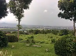
 View of Kedungkandang, Malang from Buring hills | |
| Coordinates: 8.011917°S 112.644189°E | |
| Country | |
| Province | |
| City | |
| Area | |
| • Total | 39.89 km2 (15.40 sq mi) |
| Elevation | 464 m (1,522 ft) |
| Population (2018[1]) | |
| • Total | 192,445 |
| • Density | 4,800/km2 (12,000/sq mi) |
| Website | keckedungkandang |
Subdistricts
There are 12 subdistricts (kelurahan) in Kedungkandang:[5]
- Mergosono, postal code 65134
- Bumiayu, postal code 65135
- Wonokoyo, postal code 65135
- Buring, postal code 65136
- Lesanpuro, postal code 65138
- Madyopuro, postal code 65138
- Sawojajar, postal code 65139
- Arjowinangun, postal code 65132
- Cemorokandang, postal code 65138
- Kedungkandang, postal code 65137
- Tlogowaru, postal code 65133
- Kotalama, postal code 65136 (Kotalama in English means old town, because the history of early Malang settlements located in this subdistrict).[6]
Geography
Northern side of Kedungkandang bordering with Blimbing district, eastern and southern side bordering with Malang Regency, and western side of Kedungkandang bordering with the Sukun and Lowokwaru districts.[4]
Climate
The climate in Kedungkandang features tropical monsoon climate (Am) according to Köppen–Geiger climate classification system, as the climate precipitation throughout the year is greatly influenced by the monsoon, bordering with subtropical highland climate (Cwb). Most months of the year are marked by significant rainfall. The short dry season has little impact. The average temperature in Kedungkandang is 23.7 °C. In a year, the average rainfall is 2153 mm.
| Climate data for Kedungkandang, Malang (elevation 464 m or 1,522 ft) | |||||||||||||
|---|---|---|---|---|---|---|---|---|---|---|---|---|---|
| Month | Jan | Feb | Mar | Apr | May | Jun | Jul | Aug | Sep | Oct | Nov | Dec | Year |
| Average high °C (°F) | 28.5 (83.3) |
28.5 (83.3) |
28.5 (83.3) |
28.7 (83.7) |
29 (84) |
28.8 (83.8) |
28.3 (82.9) |
29.2 (84.6) |
29.8 (85.6) |
30.3 (86.5) |
29.5 (85.1) |
28.4 (83.1) |
29.0 (84.1) |
| Daily mean °C (°F) | 24.1 (75.4) |
24.1 (75.4) |
23.9 (75.0) |
24 (75) |
23.9 (75.0) |
23.2 (73.8) |
22.3 (72.1) |
23 (73) |
23.6 (74.5) |
24.4 (75.9) |
24.3 (75.7) |
23.7 (74.7) |
23.7 (74.6) |
| Average low °C (°F) | 19.7 (67.5) |
19.7 (67.5) |
19.4 (66.9) |
19.3 (66.7) |
18.9 (66.0) |
17.7 (63.9) |
16.4 (61.5) |
16.9 (62.4) |
17.4 (63.3) |
18.5 (65.3) |
19.1 (66.4) |
19 (66) |
18.5 (65.3) |
| Average precipitation mm (inches) | 340 (13.4) |
307 (12.1) |
301 (11.9) |
179 (7.0) |
141 (5.6) |
81 (3.2) |
52 (2.0) |
26 (1.0) |
48 (1.9) |
110 (4.3) |
234 (9.2) |
334 (13.1) |
2,153 (84.7) |
| Average relative humidity (%) | 81.7 | 82.3 | 82.2 | 79.2 | 79.8 | 77.3 | 75.1 | 72.9 | 70.9 | 70.9 | 74.4 | 79.1 | 77.1 |
| Source 1: Climate-Data.org (temp & precip)[7] | |||||||||||||
| Source 2: Weatherbase (humidity)[8] | |||||||||||||
See also
- Districts of East Java
- List of districts of Indonesia
References
- "Data Penduduk – Kecamatan Kedungkandang Kota Malang" (in Indonesian). Retrieved 2019-04-21.
- "Sawah Aktif di Kota Malang Tersisa 821 Hektare | Jatim TIMES - Lingkungan". Jatim TIMES (in Indonesian). Retrieved 2019-04-21.
- Akaibara (2016-03-30). "Profil Kelurahan Kotalama, Kecamatan Kedungkandang, Kota Malang". Ngalam.co (in Indonesian). Retrieved 2019-04-21.
- "Gambaran Umum – Kecamatan Kedungkandang Kota Malang" (in Indonesian). Retrieved 2019-04-21.
- "Kelurahan – Kecamatan Kedungkandang Kota Malang" (in Indonesian). Retrieved 2019-04-21.
- "Wisata Sejarah di Kota Malang Jawa Timur". gpswisataindonesia.info (in Indonesian). Retrieved 2019-04-21.
- "Climate: Kedungkandang, Malang". Climate-Data.org. Retrieved 20 April 2019.
- "Malang, Indonesia". Weatherbase. Retrieved 20 April 2019.