Keilah
Keilah (Hebrew: קעילה), meaning Citadel, was a city in the lowlands of Judah (Joshua 15:44). It is now a ruin, known as Kh. Qeila, near the modern village of Qila, 7 miles (11 km) east of Beit Gubrin, and about 3 kilometres (1.9 mi) west of Kharas.[1]
Keilah
قيلة Arabic קעילה Hebrew | |
|---|---|
Village | |
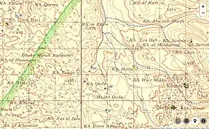 Old map showing ruin of Keilah (Kh. Qeila) in relation to Green Line | |
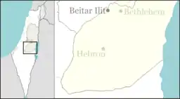 Keilah Location of Keilah | |
| Coordinates: 31°36′58″N 35°00′11″E | |
| Region | West Bank |
| District | Judea and Samaria Area |
| Government | |
| • Council | Har Hevron (Mount Hebron) Regional Council |
| Population (2006) | |
| • Total | 918 |
| Time zone | UTC+2 (IST) |
| • Summer (DST) | UTC+3 (IDT) |
History
According to the biblical narrative in the first Book of Samuel, the Philistines had made an inroad eastward as far as Keilah, and had begun to appropriate the country for themselves by plundering its granaries, until David prevented them (1 Samuel 23:1). Later, upon inquiry, he learnt that the inhabitants of the town, his native countrymen, would prove unfaithful to him, in that they would deliver him up to King Saul (1 Samuel 23:10–12), at which time he and his 600 men "departed from Keilah, and went whithersoever they could go”. They fled to the woods in the wilderness of Ziph. "And David was in the wilderness of Ziph, in a wood" (1 Samuel 23:15). Here his friend Jonathan sought him out, "and strengthened his hand in God": this was the last meeting between David and Jonathan (1 Samuel 23:16–18).
Keilah is mentioned in the Book of Joshua (15:44) as one of the cities of the Shephelah ("lowlands"). Benjamin of Tudela identified Kâkôn (Qaqun) as ancient Keilah in 1160.[2] Conder and Kitchener, however, identified the biblical site with the ruin Kila, "seven English-miles from Beit Jibrin,"[3] and 11 km (7 mi) northwest of Hebron.[4] The site was earlier described by Eusebius in his Onomasticon as being "[nearly] eight milestones east of Eleutheropolis, on the road to Hebron."[5] Victor Guérin, who visited Palestine between the years 1852–1888, also identified Keilah with the same ruin, Khirbet Kila (Arabic: خربة كيلا), near the modern village by that name,[6] a place situated a few kilometers south of Adullam (Khurbet esh Sheikh Madhkur) and west of Kharas. This view has been adopted by the Israel Antiquities Authority. The ruin, Khirbet Kila, lies on the north side of the village Kila. Guérin found here a subterranean and circular vault, apparently ancient; the vestiges of a wall surrounding the plateau, and on the side of a neighboring hill, tombs cut in the rock face.[7] The town is mentioned in the Amarna tablets under the corruption Ḳilta.
During the Second Temple period, pressed figs shaped into hard round or square-shaped cakes (called develah) were produced in Keilah and because of their exceptionally good and succulent quality, as well as sweetness, were permitted to be offered as such in the Temple as First-fruits, a thing normally reserved only for fresh fruits (when brought from places near Jerusalem), and for raisins and dried figs when brought from distant places.[8][1]
The town's present residents are Bedouins who were expelled during 1948 Arab–Israeli War from areas around Beer Sheba.
Description of ruin
Khirbet Qeila (Ruin of Keilah) is situated on a dome-shaped hill at the end of a spur that descends to the east, adjacent to a small Arab village which bears the same name.[1] On the other side it is surrounded by channels, which descend into the watercourse of Wadi es-Sur (an extension of the Elah Valley) and fortify it with a natural fortification.[1] Its area is about 50 dunams (12.3 acres).[1] Remains of walls can be seen on its slopes, and in the north is seen the ascent to the city gate, which is made like unto a ramp with a retaining wall.[1] At the foot of the tell, on the side of the road, burial caves were hewn.[1] The pottery finds at the tell indicate that it had an almost continuous settlement from the Bronze Age to the Crusader and Mamluk periods.[1]
The remnants of an old road leading from Keilah to the Elah Valley via Adullam can still be seen, and from Keilah to Tarqumiyah. Another ancient road breaks off from Keilah in the direction of Kefar Bish, now a ruin 4.5 kilometres (2.8 mi) to the west of Keilah, but once a Jewish village settled during the Roman occupation of Palestine.[1]
References
- Amit (n.d.), p. 308
- Conder, 2002, p. 213.
- Conder and Kitchener, 1883, SWP III, p. 314
- David Toshio Tsumura, The First Book of Samuel (NICOT; Grand Rapids: Eerdmans, 2007), 550.
- Chapmann III, et al. (2003), p. 65
- Guérin, 1869, pp. 341–343; Guérin, 1869, pp. 350-351.
- Conder and Kitchener, 1883, SWP III, p. 118.
- Jerusalem Talmud (Bikkurim 3:3), Solomon Sirilio's commentary there.
Bibliography
- Amit, David (n.d.). "Keilah (Qila)". In Ben-Yosef, Sefi (ed.). Israel Guide - Judaea (A useful encyclopedia for the knowledge of the country) (in Hebrew). 9. Jerusalem: Keter Publishing House, in affiliation with the Israel Ministry of Defence. OCLC 745203905.
- Chapmann III, R.L.; Taylor, J.E., eds. (2003). Palestine in the Fourth Century A.D.: The Onomasticon by Eusebius of Caesarea. Translated by G.S.P. Freeman-Grenville. Jerusalem: Carta. ISBN 965-220-500-1. OCLC 937002750.
- Conder, C.R. (2002). Tent Work in Palestine: A Record of Discovery and Adventure. Adamant Media Corporation. ISBN 978-1-4021-8987-6.
- Conder, C.R.; Kitchener, H.H. (1883). The Survey of Western Palestine: Memoirs of the Topography, Orography, Hydrography, and Archaeology. 3. London: Committee of the Palestine Exploration Fund.
- Guérin, Victor (1869). Description Géographique Historique et Archéologique de la Palestine (in French). 1: Judee, pt. 3. Paris: L'Imprimerie Nationale.
![]() This article incorporates text from a publication now in the public domain: Easton, Matthew George (1897). Easton's Bible Dictionary (New and revised ed.). T. Nelson and Sons. Missing or empty
This article incorporates text from a publication now in the public domain: Easton, Matthew George (1897). Easton's Bible Dictionary (New and revised ed.). T. Nelson and Sons. Missing or empty |title= (help)
External links
- Survey of Western Palestine, Map 21: IAA, Wikimedia commons
